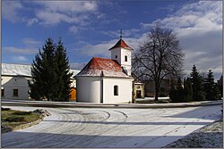
Slatinky
| Slatinky | ||
|---|---|---|
| Municipality | ||
 | ||
| ||
 Slatinky | ||
| Coordinates: 49°32′53″N 17°5′13″E / 49.54806°N 17.08694°E / 49.54806; 17.08694Coordinates: 49°32′53″N 17°5′13″E / 49.54806°N 17.08694°E / 49.54806; 17.08694 | ||
| Country | ||
| Region | Olomouc | |
| District | Prostějov | |
| Area | ||
| • Total | 8.02 km2 (3.10 sq mi) | |
| Elevation | 272 m (892 ft) | |
| Population (2006) | ||
| • Total | 492 | |
| • Density | 61/km2 (160/sq mi) | |
| Postal code | 783 42 | |
| Website | http://slatinky.cz | |
Slatinky is a village and municipality (obec) in Prostějov District in the Olomouc Region of the Czech Republic.
The municipality covers an area of 8.02 square kilometres (3.10 sq mi), and has a population of 492 (as at 28 August 2006).
Slatinky lies approximately 9 kilometres (6 mi) north of Prostějov, 13 km (8 mi) south-west of Olomouc, and 201 km (125 mi) east of Prague.
There is a natural monument Vápenice in the southern part of the territory of the municipality.[1]
Notes
^ "PP Vápenice". Ústřední seznam ochrany přírody. Nature Conservation Agency of the Czech Republic (AOPK ČR). Retrieved 2014-05-02..mw-parser-output cite.citation{font-style:inherit}.mw-parser-output q{quotes:"""""""'""'"}.mw-parser-output code.cs1-code{color:inherit;background:inherit;border:inherit;padding:inherit}.mw-parser-output .cs1-lock-free a{background:url("//upload.wikimedia.org/wikipedia/commons/thumb/6/65/Lock-green.svg/9px-Lock-green.svg.png")no-repeat;background-position:right .1em center}.mw-parser-output .cs1-lock-limited a,.mw-parser-output .cs1-lock-registration a{background:url("//upload.wikimedia.org/wikipedia/commons/thumb/d/d6/Lock-gray-alt-2.svg/9px-Lock-gray-alt-2.svg.png")no-repeat;background-position:right .1em center}.mw-parser-output .cs1-lock-subscription a{background:url("//upload.wikimedia.org/wikipedia/commons/thumb/a/aa/Lock-red-alt-2.svg/9px-Lock-red-alt-2.svg.png")no-repeat;background-position:right .1em center}.mw-parser-output .cs1-subscription,.mw-parser-output .cs1-registration{color:#555}.mw-parser-output .cs1-subscription span,.mw-parser-output .cs1-registration span{border-bottom:1px dotted;cursor:help}.mw-parser-output .cs1-hidden-error{display:none;font-size:100%}.mw-parser-output .cs1-visible-error{font-size:100%}.mw-parser-output .cs1-subscription,.mw-parser-output .cs1-registration,.mw-parser-output .cs1-format{font-size:95%}.mw-parser-output .cs1-kern-left,.mw-parser-output .cs1-kern-wl-left{padding-left:0.2em}.mw-parser-output .cs1-kern-right,.mw-parser-output .cs1-kern-wl-right{padding-right:0.2em}
References
| Wikimedia Commons has media related to Slatinky. |
- Olomouc Regional Statistical Office: Municipalities of Prostějov District
This Olomouc Region location article is a stub. You can help Wikipedia by expanding it. |


