Piyanets Ridge
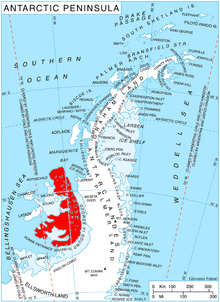
Location of Alexander Island in the Antarctic Peninsula region
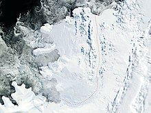
Satellite image of Alexander Island
Piyanets Ridge (Bulgarian: рид Пиянец, ‘Rid Piyanets’ 'rid pi-ya-'nets) is the upturned V-shaped, mostly ice-free ridge extending 5.6 km in north-south direction, 2.4 km wide and rising to 1000 m in Havre Mountains, northern Alexander Island in Antarctica. It surmounts Kolokita Cove to the southwest. The feature is named after the region of Piyanets in Western Bulgaria.
Location
Piyanets Ridge is located at 69°20′24″S 71°46′20″W / 69.34000°S 71.77222°W / -69.34000; -71.77222Coordinates: 69°20′24″S 71°46′20″W / 69.34000°S 71.77222°W / -69.34000; -71.77222, which is 4.55 km northeast of the coastal point formed by Hopkins Ridge, 3.77 km southeast of Gazey Nunatak and 9.2 km northwest of Mount Holt.
Maps
- British Antarctic Territory. Scale 1:200000 topographic map. DOS 610 – W 69 70. Tolworth, UK, 1971
Antarctic Digital Database (ADD). Scale 1:250000 topographic map of Antarctica. Scientific Committee on Antarctic Research (SCAR). Since 1993, regularly upgraded and updated
References
Bulgarian Antarctic Gazetteer. Antarctic Place-names Commission. (details in Bulgarian, basic data in English)
Piyanets Ridge. SCAR Composite Gazetteer of Antarctica
This article includes information from the Antarctic Place-names Commission of Bulgaria which is used with permission.
This Alexander Island location article is a stub. You can help Wikipedia by expanding it. |


