Lower Silesian Voivodeship
Lower Silesian Voivodeship Województwo dolnośląskie | |||
|---|---|---|---|
| Voivodeship | |||
| |||
 Location within Poland | |||
 Division into counties | |||
| Coordinates (Wrocław): 51°07′N 17°02′E / 51.117°N 17.033°E / 51.117; 17.033 | |||
| Country | |||
| Capital | Wrocław | ||
Counties* | List
| ||
| Area | |||
| • Total | 19,946.74 km2 (7,701.48 sq mi) | ||
| Population (30-06-2014) | |||
| • Total | 2,908,457 | ||
| • Density | 150/km2 (380/sq mi) | ||
| • Urban | 2,047,151 | ||
| • Rural | 837,097 | ||
| Car plates | D | ||
| Website | http://www.umwd.pl/ | ||
| |||


Lower Silesian Voivodeship, or Lower Silesia Province[1] (Polish: województwo dolnośląskie [vɔjɛˈvut͡stfɔ dɔlnɔˈɕlɔ̃skʲɛ]), in southwestern Poland, is one of the 16 voivodeships (provinces) into which Poland is divided.
Lower Silesia was part of Medieval Poland during the Piast dynasty. After the testament of Bolesław III Wrymouth in 1138, Poland entered a period of fragmentation. Silesia became a province of Poland as a duchy, which later on became divided into many small duchies reigned by dukes and princes of the Piast dynasty. During this time, cultural and ethnic Germanic influence prospered due to immigrants from the German-speaking areas of the Holy Roman Empire. This also impacted on the local architecture as well as traditions and cuisine. At the same time, Lower Silesia was a leading Polish cultural center. The Book of Henryków, which contains the earliest known sentence written in the Polish language, as well as Statuta synodalia Episcoporum Wratislaviensis, which contains the oldest printed text in Polish, were both created here. Both texts can be seen in Wrocław. Złotoryja, Poland's first town, was granted municipal privileges by Henry the Bearded. Over the centuries, Lower Silesia has experienced epochal events such as the Protestant Reformation, the Silesian Wars, industrialisation, and the two World Wars.
Lower Silesia is one of the richest provinces in Poland as it has valuable natural resources such as copper, brown coal and rock materials, which are exploited by the biggest enterprises. Its well developed and varied industries attract both domestic and foreign investors.[2]
Its capital and largest city is Wrocław, situated on the Odra River. It is one of Poland's largest and most dynamic cities with a rapidly growing international profile, and is regarded as one of the most important commercial, educational and tourist sites in the whole country. Burial sites of Polish monarchs and consorts are located in Wrocław and Trzebnica. Furthermore, the voivodeship is famous for its many castles and palaces and is one of Poland's most visited regions by tourists.
Contents
1 History and geography
2 Transport
3 Tourism
4 Protected areas
5 Economy
6 Cities and towns
7 Administrative division
8 Governors
9 See also
10 References
11 External links
History and geography
The voivodeship was created on 1 January 1999 out of the former Wrocław, Legnica, Wałbrzych and Jelenia Góra Voivodeships, following the Polish local government reforms adopted in 1998. It covers an area of 19,946 square kilometres (7,701 sq mi), and as of 2013[update] has a total population of 2 914 362.
Although much of the region is relatively low-lying it also includes Sudeten Foreland and part of the Sudetes mountain range running along the Polish/Czech border. Popular ski resorts in Lower Silesian Voivodeship include Karpacz and Szklarska Poręba in the Karkonosze mountains. Other important tourist destinations in the voivodeship include the chief city, Wrocław, as well as the towns of Jelenia Góra and Legnica. The town of Boleslawiec is famed for its pottery.
The voivodeship has the largest number of spa towns in Poland: Cieplice Śląskie-Zdrój, Długopole-Zdrój, Duszniki-Zdrój, Jedlina-Zdrój, Kudowa-Zdrój, Lądek-Zdrój, Polanica-Zdrój, Przerzeczyn-Zdrój, Szczawno-Zdrój, Świeradów-Zdrój.
Lower Silesian Voivodeship is bordered by Lubusz Voivodeship to the north-west, Greater Poland Voivodeship to the north-east, Opole Voivodeship to the south-east, the Czech Republic to the south, and Germany (the State of Saxony) to the west.
Transport
The Wrocław–Copernicus Airport serves as an international and domestic airport.
The main railway station is Wrocław Główny.
The A4 motorway, A8 motorway and A18 motorway run through the Voivodeship.

Wrocław Główny railway station is a major railway hub in the region

Jelenia Góra railway station
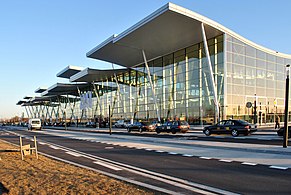
Copernicus Airport Wrocław

A4 motorway in Jędrzychowice

Overpass in Lewin Kłodzki


Tourism

Wrocław Town Hall
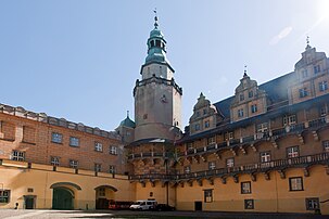
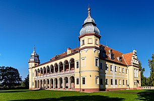
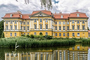
Lower Silesian Voivodeship is one of the most visited voivodeships in Poland. It is famous for a large number of castles (99) and palaces (hundreds), inter alia: Książ Castle, Czocha Castle, Chojnik Castle, Grodziec castle, Gorzanów Castle, Kliczków Castle. There is also a lot in the Jelenia Góra valley.
The voivodship's most widely visited city is Wrocław with many sights and attractions, inter alia open all year round Aquapark, Wrocław SPA Center and famous Wrocław's dwarfs.
The annual international Chopin Festival is held in the Fryderyk Chopin Theatre in Duszniki-Zdrój, established at the site of the first concert played by the Polish virtuoso pianist outside of the Russian Partition of Poland. Other major attraction of the town is the Museum of Papermaking, established in a 17th-century paper mill.
The Festival of Good Beer is held every year, on the second weekend of June.
Śnieżka is one of the first European peaks visited by tourists, it is also the highest peak of the Lower Silesian Voivodeship and the whole of the Sudetes.
Other highlights include:
Kłodzko Fortress, Fort Srebrna Góra, Wambierzyce, Legnickie Pole, Henryków, Lubiąż Abbey, Krzeszów Abbey, Oleśnica Mała, Vang stave church, Churches of Peace, Sokołowsko, Cave Bear, Museum of Gold Mining and Metallurgy in Złoty Stok, Coal Mine in Nowa Ruda, Museum of Industry and Railway in Jaworzyna Śląska, Skull Chapel in Czermna, Mount Ślęża, Table Mountains, Owl Mountains, Karkonosze, The Main Trail Sudetes, Barycz Valley Landscape Park and connected with the history of World War II - complex tunnels Project Riese, a German Gross-Rosen concentration camp, German War Cemetery and Park Peace in the Nadolice Wielkie.
- Castles and palaces (examples)

Książ Castle in Wałbrzych

Piast Castle in Legnica

Czocha Castle
Oleśnica Castle
Krobielowice Palace
Radomierzyce Palace

Jedlinka Palace in Jedlina-Zdrój

Wojanów Palace

Kamieniec Ząbkowicki Palace


- Burial sites of Polish monarchs and consorts
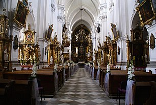
Sanctuary of St. Jadwiga, Trzebnica

Cathedral of St. Vincent and St. James, Wrocław

Holy Cross Church, Wrocław
Church of St. Clare and Hedwig church, Wrocław


Protected areas

Mount Ślęża

Table Mountains National Park
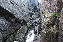
"Hell" on Szczeliniec Wielki (Table Mountains National Park)

Project Riese, Owl Mountains

Snowy Pits
Protected areas in Lower Silesian Voivodeship:
- 2 National Parks
Karkonosze National Park (part of a UNESCO trans-border biosphere reserve)- Table Mountains National Park
- 12 Landscape Parks
Barycz Valley Landscape Park (partly in Greater Poland Voivodeship)
- Bóbr Valley Landscape Park
- Bystrzyca Valley Landscape Park
- Chełmy Landscape Park
- Jezierzyca Valley Landscape Park
- Książ Landscape Park
- Owl Mountains Landscape Park
- Przemków Landscape Park
- Rudawy Landscape Park
- Ślęża Landscape Park
- Śnieżnik Landscape Park
- Sudety Wałbrzyskie Landscape Park
- 67 Nature reserves
- 20 protected landscape areas
- 3100 Natural monuments
- 114 Ecological usages
- 15 Teams nature and landscape
and many areas of Natura 2000 network.
Economy
Lower Silesia is one of the richest regions in Poland. GDP per capita in 2007 accounted for 108.7% of the average for the country.
Since 2005, the voivodeship recorded the highest in the country economic growth rate (around 10% per annum).
GDP per capita in Lower Silesia Voivodeship: GDP in Poland:
| Lower Silesian Voivodeship | GDP per capita | Poland | GDP per capita |
|---|---|---|---|
| 2000 | $10 440 (+2.8%) | 2000 | $10 140 (+4.0%) |
| 2005 | $13 060 (+4.9%) | 2005 | $12 600 (+3.5%) |
| 2006 | $13 700 (+7.3%) | 2006 | $13 020 (+6.2%) |
| 2007 | $14 980 (+9.5%) | 2007 | $13 760 (+6.5%) |
| 2008 | $16 030 (+7.2%) | 2008 | $14 450 (+5.0%) |
| 2009 | $16 350 (+2.0%) | 2009 | $14 720 (+1.9%) |
The southwest part of the Voivodeship is considered part of the so-called Black Triangle, an area of heavily industrialization and environmental damage on the three-way border of Poland, Germany, and the Czech Republic.[3]
Cities and towns

Legnica

Jelenia Góra

Głogów

Bolesławiec, known for its pottery

Kłodzko
The voivodeship contains 91 cities and towns. These are listed below in descending order of population (according to official figures for 2006[4]):
Wrocław city county (631,188)
Wałbrzych city county (119,955)
Legnica city county (102,708)
Jelenia Góra city county (83,097)
Lubin (74,886)
Głogów (69,608)
Świdnica (60,213)
Bolesławiec (40,837)
Oleśnica (36,951)
Dzierżoniów (34,678)
Zgorzelec (32,925)
Bielawa (31,219)
Oława (30,908)
Kłodzko (28,249)
Jawor (24,347)
Nowa Ruda (24,261)
Świebodzice (23,126)
Polkowice (22,279)
Lubań (22,137)
Kamienna Góra (21,440)
Bogatynia (19,068)
Strzegom (16,782)
Boguszów-Gorce (16,687)
Złotoryja (16,503)
Ząbkowice Śląskie (16,242)
Jelcz-Laskowice (15,196)
Chojnów (14,389)
Brzeg Dolny (12,786)
Góra (12,574)
Wołów (12,286)
Strzelin (12,192)
Trzebnica (12,180)
Milicz (12,004)
Kowary (11,824)
Syców (10,712)
Bystrzyca Kłodzka (10,638)
Kudowa-Zdrój (10,204)
Lwówek Śląski (9,687)
Pieszyce (9,490)
Ziębice (9,234)
Środa Śląska (8,800)
Oborniki Śląskie (8,426)
Chocianów (8,215)
Gryfów Śląski (7,128)
Szklarska Poręba (7,094)
Głuszyca (6,999)
Żarów (6,902)
Polanica-Zdrój (6,900)
Twardogóra (6,866)
Sobótka (6,780)
Piława Górna (6,779)
Żmigród (6,573)
Przemków (6,551)
Lubawka (6,529)
Piechowice (6,494)
Stronie Śląskie (6,246)
Lądek-Zdrój (6,181)
Ścinawa (5,934)
Pieńsk (5,799)
Szczawno-Zdrój (5,506)
Kąty Wrocławskie (5,418)
Bolków (5,380)
Jaworzyna Śląska (5,240)
Szczytna (5,234)
Jedlina-Zdrój (5,116)
Duszniki-Zdrój (5,113)
Bierutów (5,066)
Karpacz (5,063)
Olszyna (4,786)
Leśna (4,752)
Świeradów-Zdrój (4,554)
Mieroszów (4,515)
Zawidów (4,412)
Mirsk (4,136)
Nowogrodziec (4,055)
Wojcieszów (3,940)
Siechnice (3,851)
Prochowice (3,702)
Niemcza (3,121)
Węgliniec (3,072)
Złoty Stok (2,930)
Bardo (2,860)
Wąsosz (2,828)
Międzylesie (2,776)
Radków (2,460)
Świerzawa (2,439)
Międzybórz (2,356)
Wiązów (2,230)
Prusice (2,203)
Wleń (1,884)
Lubomierz (1,818)
Administrative division

Map of the powiats (counties)

The Skull Chapel in Kudowa

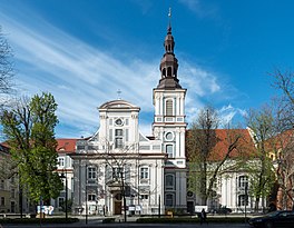
The Church of Peace in Świdnica is a UNESCO World Heritage Site
Lower Silesian Voivodeship is divided into 30 counties (powiats), four of which are city counties. These are further divided into 169 gminas.

Cistercian Lubiąż Abbey
Lower Silesia is divided into three districts administracyji province government, the capital of Wrocław (administrative region):[5]

800-year old Vang stave church in Karpacz

Abbey of the Order of Saint Benedict in Krzeszów

Henryków Abbey
]]
1 one district Wałbrzyski
- Powiats in the district
Świdnica, Kłodzko, Ząbkowice Śląskie, Dzierżoniów
2 second district Legnicki
- Powiats in the district
Glogów, Jawor, Lubin, Polkowice, Złotoryja
3 third district Jeleniogórski
- Powiats in the district
Boleslawiec, Kamienna Góra, Luban, Lwówek Slaski, Zgorzelec.
The counties are listed in the following table (ordering within categories is by decreasing population).
English and Polish names | Area (km²) | Population (2014) | Seat | Other towns | Total gminas |
City counties | |||||
Wrocław | 293 | 633 105 | 1 | ||
Wałbrzych | 84.70 | 117 264 | 1 | ||
Legnica | 56.29 | 101 768 | 1 | ||
Jelenia Góra | 109.22 | 81 640 | 1 | ||
Land counties | |||||
Wałbrzych County powiat wałbrzyski | 430.22 | 57 620 | Wałbrzych * | Boguszów-Gorce, Głuszyca, Szczawno-Zdrój, Jedlina-Zdrój, Mieroszów | 9 |
Kłodzko County powiat kłodzki | 1643.37 | 164 155 | Kłodzko | Nowa Ruda, Bystrzyca Kłodzka, Kudowa-Zdrój, Polanica-Zdrój, Stronie Śląskie, Lądek-Zdrój, Szczytna, Duszniki-Zdrój, Międzylesie, Radków | 14 |
Świdnica County powiat świdnicki | 742.89 | 160 658 | Świdnica | Świebodzice, Strzegom, Żarów, Jaworzyna Śląska | 8 |
Lubin County powiat lubiński | 711.99 | 106 437 | Lubin | Ścinawa | 4 |
Dzierżoniów County powiat dzierżoniowski | 478.34 | 104 285 | Dzierżoniów | Bielawa, Gola Dzierżoniowska, Niemcza, Pieszyce, Piława Górna | 7 |
Oleśnica County powiat oleśnicki | 1049.74 | 106 167 | Oleśnica | Syców, Twardogóra, Bierutów, Międzybórz | 8 |
Wrocław County powiat wrocławski | 1116.15 | 129 576 | Wrocław * | Sobótka, Kąty Wrocławskie, Siechnice | 9 |
Zgorzelec County powiat zgorzelecki | 838.11 | 92 799 | Zgorzelec | Bogatynia, Pieńsk, Zawidów, Węgliniec | 7 |
Bolesławiec County powiat bolesławiecki | 1303.26 | 90 295 | Bolesławiec | Nowogrodziec | 6 |
Głogów County powiat głogowski | 443.06 | 90 194 | Głogów | 6 | |
Trzebnica County powiat trzebnicki | 1025.55 | 83 176 | Trzebnica | Oborniki Śląskie, Żmigród, Prusice | 6 |
Oława County powiat oławski | 523.73 | 75 869 | Oława | Jelcz-Laskowice | 4 |
Ząbkowice Śląskie County powiat ząbkowicki | 801.75 | 67 614 | Ząbkowice Śląskie | Ziębice, Złoty Stok, Bardo | 7 |
Jelenia Góra County powiat jeleniogórski | 628.21 | 65 069 | Jelenia Góra * | Kowary, Szklarska Poręba, Piechowice, Karpacz | 9 |
Polkowice County powiat polkowicki | 779.93 | 63 185 | Polkowice | Chocianów, Przemków | 6 |
Lubań County powiat lubański | 428.30 | 55 919 | Lubań | Olszyna, Leśna, Świeradów-Zdrój | 7 |
Legnica County powiat legnicki | 744.60 | 54 929 | Legnica * | Chojnów, Prochowice | 8 |
Jawor County powiat jaworski | 581.25 | 51 949 | Jawor | Bolków | 6 |
Środa Śląska County powiat średzki | 703.68 | 52 543 | Środa Śląska | 5 | |
Lwówek Śląski County powiat lwówecki | 709.94 | 47 120 | Lwówek Śląski | Gryfów Śląski, Mirsk, Wleń, Lubomierz | 5 |
Wołów County powiat wołowski | 675.00 | 47 475 | Wołów | Brzeg Dolny | 3 |
Kamienna Góra County powiat kamiennogórski | 396.13 | 44 824 | Kamienna Góra | Lubawka | 4 |
Złotoryja County powiat złotoryjski | 575.45 | 44 893 | Złotoryja | Wojcieszów, Świerzawa | 6 |
Strzelin County powiat strzeliński | 622.27 | 44 322 | Strzelin | Wiązów | 5 |
Milicz County powiat milicki | 715.01 | 37 286 | Milicz | 3 | |
Góra County powiat górowski | 738.11 | 36 321 | Góra | Wąsosz | 4 |
| * seat not part of the county | |||||
Governors
| Name | Period |
|---|---|
Witold Krochmal | 4 January 1999 - 22 October 2001 |
| Ryszard Nawrat | 22 October 2001 - 21 March 2003 |
Stanisław Łopatowski | 31 March 2003 - 21 December 2005 |
Krzysztof Grzelczyk | 21 December 2005 - 29 November 2007 |
Rafał Jurkowlaniec | 29 November 2007 - 1 December 2010 |
Aleksander Skorupa | 28 December 2010 - |
See also
- Princess Marianne of the Netherlands
- Tourism in Poland
References
^ Arkadiusz Belczyk,Tłumaczenie polskich nazw geograficznych na język angielski [Translation of Polish Geographical Names into English], 2002-2006.
^ "Past and Present Regions of Poland - Lower Silesia". Retrieved 10 March 2017..mw-parser-output cite.citation{font-style:inherit}.mw-parser-output q{quotes:"""""""'""'"}.mw-parser-output code.cs1-code{color:inherit;background:inherit;border:inherit;padding:inherit}.mw-parser-output .cs1-lock-free a{background:url("//upload.wikimedia.org/wikipedia/commons/thumb/6/65/Lock-green.svg/9px-Lock-green.svg.png")no-repeat;background-position:right .1em center}.mw-parser-output .cs1-lock-limited a,.mw-parser-output .cs1-lock-registration a{background:url("//upload.wikimedia.org/wikipedia/commons/thumb/d/d6/Lock-gray-alt-2.svg/9px-Lock-gray-alt-2.svg.png")no-repeat;background-position:right .1em center}.mw-parser-output .cs1-lock-subscription a{background:url("//upload.wikimedia.org/wikipedia/commons/thumb/a/aa/Lock-red-alt-2.svg/9px-Lock-red-alt-2.svg.png")no-repeat;background-position:right .1em center}.mw-parser-output .cs1-subscription,.mw-parser-output .cs1-registration{color:#555}.mw-parser-output .cs1-subscription span,.mw-parser-output .cs1-registration span{border-bottom:1px dotted;cursor:help}.mw-parser-output .cs1-hidden-error{display:none;font-size:100%}.mw-parser-output .cs1-visible-error{font-size:100%}.mw-parser-output .cs1-subscription,.mw-parser-output .cs1-registration,.mw-parser-output .cs1-format{font-size:95%}.mw-parser-output .cs1-kern-left,.mw-parser-output .cs1-kern-wl-left{padding-left:0.2em}.mw-parser-output .cs1-kern-right,.mw-parser-output .cs1-kern-wl-right{padding-right:0.2em}
^ "Archived copy" (PDF). Archived from the original (PDF) on 2014-04-13. Retrieved 2014-04-16.CS1 maint: Archived copy as title (link) page 9
^ "Archived copy". Archived from the original on 2008-05-05. Retrieved 2008-05-05.CS1 maint: Archived copy as title (link)
^ Internet, JSK. "Delegatury Urzędu - Dolnośląski Urząd Wojewódzki". Retrieved 10 March 2017.
External links
| Wikivoyage has a travel guide for Dolnośląskie. |
Województwo Dolnośląskie Official website- Website of the government of Lower Silesia
Places adjacent to Lower Silesian Voivodeship | ||||||||||
|---|---|---|---|---|---|---|---|---|---|---|
Counties of Lower Silesian Voivodeship | ||
|---|---|---|
| City counties |
|  |
| Land counties |
| |
Voivodeships of Poland | ||
|---|---|---|
| ||
Silesia topics | |||||||||||||||||||||||||||||
|---|---|---|---|---|---|---|---|---|---|---|---|---|---|---|---|---|---|---|---|---|---|---|---|---|---|---|---|---|---|
| |||||||||||||||||||||||||||||
| |||||||||||||||||||||||||||||
| |||||||||||||||||||||||||||||
| |||||||||||||||||||||||||||||
| |||||||||||||||||||||||||||||
| |||||||||||||||||||||||||||||
Coordinates: 51°05′N 16°24′E / 51.083°N 16.400°E / 51.083; 16.400
Authority control |
|
|---|


