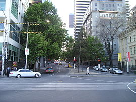
William Street, Melbourne
William Street Victoria | |
|---|---|
 | |
William Street facing north from Flinders Street | |
| General information | |
| Type | Street |
| Length | 2.1 km (1.3 mi) |
| Major junctions | |
| North end | |
| |
| South end | Queensbridge Street |
| Location(s) | |
| Suburb(s) | Melbourne CBD, West Melbourne |
William Street is a major street in the central business district of Melbourne, Victoria, Australia. It runs roughly north-south from Flinders Street to Victoria Street, and was laid out in 1837 as part of the original Hoddle Grid. The street is located in-between King Street and Queen Street.
Notable landmarks on William Street include the Queen Victoria Market, the Flagstaff Gardens, Immigration Museum, Supreme Court of Victoria, AMP Square and 140 William Street (formerly BHP House).
Contents
1 History
1.1 2007 shooting incident
1.2 2017 car attack
2 Notable buildings
3 Law Courts precinct
4 Transport
5 See also
6 References
History
2007 shooting incident
On 18 June 2007, a shooting incident occurred on the corner of Flinders Lane and William Street when an unknown man shot and killed a pedestrian and wounded two others.[1] Christopher Hudson later pleaded guilty to the shootings.[2]
2017 car attack
On 20 January 2017, a car was driven into pedestrians in the CBD of Melbourne, killing 5 and injuring over 20.[3] The driver was stopped when police shot him in the arm and subsequently pulled him from his vehicle on William Street (at the corner of Bourke Street).[4]
Notable buildings
Several buildings and structures on William Street are listed on the Victorian Heritage Register and/or classified by the National Trust of Australia. These include:
140 William Street (former BHP House)- Australian Club Building
- Court of Appeal
- Goldsborough Mort Building
- Hume House
Prometheus Mural in Monash House
- Queensland Building
Royal Melbourne Mint (former)- Royal Standard Hotel
- Scottish House
Shell Corner (former)- Supreme Court of Victoria
- Western House
Law Courts precinct

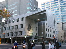
County Court of Victoria, corner of Lonsdale Street
William Street's junction with Lonsdale Street forms the legal precinct of Melbourne.[5] This junction is the location of the Supreme Court of Victoria, Melbourne Magistrates' Court and County Court. The Federal Court building, housing the High Court and other Federal courts, is located one block further north on the corner of William Street and La Trobe Street.
Transport
Flagstaff railway station is situated on William Street. Besides that, William Street is also served by a tram route. Tram route 58 runs along William Street between Peel Street and Flinders Lane.
See also
![]() Australian roads portal
Australian roads portal
References
^ One dead as police hunt Melbourne gunman. 18 June 2007. ABC News Online
^ Hudson pleads guilty over Melbourne shootings - ABC News (Australian Broadcasting Corporation)
^ Lillebuen, Steve (2017-01-22). "Bourke Street: Melbourne mourns as baby boy dies, taking death toll to five". The Age. Retrieved 2017-01-25..mw-parser-output cite.citation{font-style:inherit}.mw-parser-output q{quotes:"""""""'""'"}.mw-parser-output code.cs1-code{color:inherit;background:inherit;border:inherit;padding:inherit}.mw-parser-output .cs1-lock-free a{background:url("//upload.wikimedia.org/wikipedia/commons/thumb/6/65/Lock-green.svg/9px-Lock-green.svg.png")no-repeat;background-position:right .1em center}.mw-parser-output .cs1-lock-limited a,.mw-parser-output .cs1-lock-registration a{background:url("//upload.wikimedia.org/wikipedia/commons/thumb/d/d6/Lock-gray-alt-2.svg/9px-Lock-gray-alt-2.svg.png")no-repeat;background-position:right .1em center}.mw-parser-output .cs1-lock-subscription a{background:url("//upload.wikimedia.org/wikipedia/commons/thumb/a/aa/Lock-red-alt-2.svg/9px-Lock-red-alt-2.svg.png")no-repeat;background-position:right .1em center}.mw-parser-output .cs1-subscription,.mw-parser-output .cs1-registration{color:#555}.mw-parser-output .cs1-subscription span,.mw-parser-output .cs1-registration span{border-bottom:1px dotted;cursor:help}.mw-parser-output .cs1-hidden-error{display:none;font-size:100%}.mw-parser-output .cs1-visible-error{font-size:100%}.mw-parser-output .cs1-subscription,.mw-parser-output .cs1-registration,.mw-parser-output .cs1-format{font-size:95%}.mw-parser-output .cs1-kern-left,.mw-parser-output .cs1-kern-wl-left{padding-left:0.2em}.mw-parser-output .cs1-kern-right,.mw-parser-output .cs1-kern-wl-right{padding-right:0.2em}
^ "What we know about Bourke St fatalities". Retrieved 2017-01-25.
^ for LegalPrecinct.pdf Modern Future for Victoria's Historic Legal Precinct - Victorian Bar
Coordinates: 37°48′47″S 144°57′25″E / 37.813°S 144.957°E / -37.813; 144.957