Tannu-Ola mountains
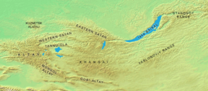
The Tannu-Ola mountains Tuvan: Таңды-Уула, Tañdı-Uula, Uniform Turkic Alphabet: Taᶇdь-Uula, IPA: [tʰaŋˈtɯ ˈuːla] – Tangdy-Uula mountains; Mongolian: Тагнын нуруу, Tağnîn nurú, Mongolian pronunciation: [tʰaɢˈniŋ nʊˈrʊː]) is a mountain range in southern Siberia, in the Tuva Republic of Russia. It extends in an east-west direction and curves along the Mongolian border. Its highest peak reaches 2,930 m (9,610 ft).
Geography
The northern slopes are part of the watershed of the Yenisei River, facing the western Sayan Mountains. The eastern end touches the large watershed of the Selenge River in Mongolia.
The foothills of the southern slopes cross into Mongolian territory. They form the northern limits of a large basin of steppes that extends south to the Mongolian Altay Mountains and includes the salt lake Uvs Nuur. The western end is located near the northern Altay Mountains in the Russian Altai Republic.
See also
- Tuva Depression
- Uvs Nuur Basin
- Ubsunur Hollow Biosphere Reserve
Coordinates: 51°04′12″N 92°23′25″E / 51.07000°N 92.39028°E / 51.07000; 92.39028
This Mongolia location article is a stub. You can help Wikipedia by expanding it. |
This Tuva location article is a stub. You can help Wikipedia by expanding it. |


