Bargal
Bargal Baargaal بارجال | |
|---|---|
| Town | |
Overview of Bargal. | |
 Bargal Location in Somalia. | |
| Coordinates: 11°17′00″N 51°05′00″E / 11.28333°N 51.08333°E / 11.28333; 51.08333Coordinates: 11°17′00″N 51°05′00″E / 11.28333°N 51.08333°E / 11.28333; 51.08333 | |
| Country |
|
| Region | Bari |
| District | Bargal |
| Population | |
| • Total | 8,200 |
| Time zone | UTC+3 (EAT) |
Bargal (Somali: Baargaal, Arabic: بارجال) is a town in the northeastern Bari region of Somalia.
Contents
1 Location
2 Overview
3 Demographics
4 Education
5 Notes
6 References
Location
Bargal is situated in the mountainous Bari province of the autonomous Puntland state. It serves as the center of the Bargal District.
A coastal town, Bargal faces the Guardafui Channel in the Indian Ocean. It lies 26 nautical miles (30 miles) north of Gumbah, 11 nautical miles (13 miles) north of Ras Binnah, 30 nautical miles (35 miles) south of Tohen, and 35 nautical miles (40 miles) south of Cape Guardafui and the entrance to the Gulf of Aden.
Overview
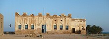
Ruins of the Majeerteen Sultanate King Osman Mahamuud's castle in Bargal, built in 1878.
Bargal was a seasonal capital of the Majeerteen Sultanate (Migiurtinia) in the pre-independence period. In June 2007, it was the location of the Battle of Bargal.
In 2012, the Puntland Highway Authority (PHA) announced a project to connect Bargal and other littoral towns in Puntland to the main regional highway.[1] The 750 km thoroughfare links major cities in the northern part of Somalia, such as Bosaso, Galkayo and Garowe, with towns in the south.[2]
Demographics
As of 2000, Bargaal had a population of around 8,200 inhabitants.[3]
Education
Bargal has a number of academic institutions. According to the Puntland Ministry of Education, there are 3 primary schools, one secondary school and also Institute in the Bargal District. These include Wadikhayr, Taageer and Bargaal Primary.[4]
Notes
^ "Puntland to upgrade Bosaso-Garowe highway". Sabahi. 28 June 2012. Retrieved 6 November 2012..mw-parser-output cite.citation{font-style:inherit}.mw-parser-output q{quotes:"""""""'""'"}.mw-parser-output code.cs1-code{color:inherit;background:inherit;border:inherit;padding:inherit}.mw-parser-output .cs1-lock-free a{background:url("//upload.wikimedia.org/wikipedia/commons/thumb/6/65/Lock-green.svg/9px-Lock-green.svg.png")no-repeat;background-position:right .1em center}.mw-parser-output .cs1-lock-limited a,.mw-parser-output .cs1-lock-registration a{background:url("//upload.wikimedia.org/wikipedia/commons/thumb/d/d6/Lock-gray-alt-2.svg/9px-Lock-gray-alt-2.svg.png")no-repeat;background-position:right .1em center}.mw-parser-output .cs1-lock-subscription a{background:url("//upload.wikimedia.org/wikipedia/commons/thumb/a/aa/Lock-red-alt-2.svg/9px-Lock-red-alt-2.svg.png")no-repeat;background-position:right .1em center}.mw-parser-output .cs1-subscription,.mw-parser-output .cs1-registration{color:#555}.mw-parser-output .cs1-subscription span,.mw-parser-output .cs1-registration span{border-bottom:1px dotted;cursor:help}.mw-parser-output .cs1-hidden-error{display:none;font-size:100%}.mw-parser-output .cs1-visible-error{font-size:100%}.mw-parser-output .cs1-subscription,.mw-parser-output .cs1-registration,.mw-parser-output .cs1-format{font-size:95%}.mw-parser-output .cs1-kern-left,.mw-parser-output .cs1-kern-wl-left{padding-left:0.2em}.mw-parser-output .cs1-kern-right,.mw-parser-output .cs1-kern-wl-right{padding-right:0.2em}
^ The First 100 Days in Office Archived February 23, 2013, at the Wayback Machine.
^ "Somalia City & Town Population". Tageo. Retrieved 4 October 2013.
^ "Puntland - Primary schools". Ministry of Education of Puntland. Retrieved 26 May 2013.
References
- Bargaal, Somalia


