Millard County, Utah
Millard County, Utah | |
|---|---|
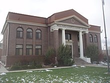 Old Millard County courthouse | |
 Location in the U.S. state of Utah | |
 Utah's location in the U.S. | |
| Founded | 1851 |
| Named for | Millard Fillmore |
| Seat | Fillmore |
| Largest city | Delta |
| Area | |
| • Total | 6,828 sq mi (17,684 km2) |
| • Land | 6,572 sq mi (17,021 km2) |
| • Water | 255 sq mi (660 km2), 3.7% |
| Population (est.) | |
| • (2017) | 12,863 |
| • Density | 2/sq mi (0.8/km2) |
| Congressional district | 2nd |
| Time zone | Mountain: UTC−7/−6 |
| Website | [<span%20class="url">.millardcounty.org www.millardcounty.org%20www<wbr/>.millardcounty<wbr/>.org]</span>] |
Millard County (/ˈmɪlərd/ MIL-ərd) is a county located in the U.S. state of Utah. As of the 2010 census, the population was 12,503.[1] Its county seat is Fillmore,[2] and the largest city is Delta. The county was created in 1851.[3] The county and its seat were named for Millard Fillmore, thirteenth President of the United States.[4]
Contents
1 Geography
1.1 Adjacent counties
1.2 National protected area
1.3 Great Stone Face
1.4 Notch Peak
1.5 Little Sahara Sand Dunes
2 Demographics
3 Economy
4 Japanese internment camp
5 Politics
6 Communities
6.1 Cities
6.2 Towns
6.3 Census-designated places
6.4 Other unincorporated places
7 Gallery
8 See also
9 References
10 External links
Geography
According to the U.S. Census Bureau, the county has a total area of 6,828 square miles (17,680 km2), of which 6,572 square miles (17,020 km2) is land and 255 square miles (660 km2) (3.7%) is water.[5] It is the third-largest county in Utah by area.
The Sevier Desert covers much of Millard County, being the seafloor of ancient Lake Bonneville. Near the center of the county lies Sevier Lake, a mostly dry remnant of Lake Bonneville. Mountains rim the area, some of which harbor beautiful forests, contrasting with the deserts below, especially the Pahvant Mountains, which form the county's eastern boundary. Fillmore and other farming communities lie at the base of the Pahvant Mountains. Delta sits several miles from the banks of the Sevier River in the middle of the basin.
Adjacent counties
Juab County (north)
Sanpete County (east)
Sevier County (east)
Beaver County (south)
Lincoln County, Nevada (southwest)
White Pine County, Nevada (west)
National protected area
Fishlake National Forest (part)
Great Stone Face

The Great Stone Face and a portrait of Joseph Smith, Jr.
The Pahvant valley in Millard County has several ancient lava flows and extinct volcanoes, including the "Black Rock" lava flow. About 17 miles southwest of Delta, near Black Rock's northwest perimeter is a feature named the "Great Stone Face", which protrudes about four stories above the general elevation.[6] For many years locals have claimed that this rock formation, when viewed at the correct angle, appears similar to a profile of Joseph Smith's face.[7][8] At ground level, within view of the "Great Stone Face", is a large, smooth-faced rock covered in Native American petroglyphs.
Notch Peak
Notch Peak is located about 50 miles to the west of Delta. The skyline appears to have a notch taken out of it when viewed from Delta.
Little Sahara Sand Dunes
Little Sahara Recreation Area is about 25 miles north of Delta. It is a very popular area for ATV riders.[9]
Demographics
| Historical population | |||
|---|---|---|---|
| Census | Pop. | %± | |
| 1860 | 715 | — | |
| 1870 | 2,753 | 285.0% | |
| 1880 | 3,727 | 35.4% | |
| 1890 | 4,033 | 8.2% | |
| 1900 | 5,678 | 40.8% | |
| 1910 | 6,118 | 7.7% | |
| 1920 | 9,659 | 57.9% | |
| 1930 | 9,945 | 3.0% | |
| 1940 | 9,613 | −3.3% | |
| 1950 | 9,387 | −2.4% | |
| 1960 | 7,866 | −16.2% | |
| 1970 | 6,988 | −11.2% | |
| 1980 | 8,970 | 28.4% | |
| 1990 | 11,333 | 26.3% | |
| 2000 | 12,405 | 9.5% | |
| 2010 | 12,503 | 0.8% | |
| Est. 2017 | 12,863 | [10] | 2.9% |
| U.S. Decennial Census[11] 1790–1960[12] 1900–1990[13] 1990–2000[14] 2010–2014[1] | |||
As of the census[15] of 2000, there were 12,405 people, 3,840 households, and 3,091 families residing in the county. The population density was 2 people per square mile (1/km²). There were 4,522 housing units at an average density of 1 per square mile (0/km²). The racial makeup of the county was 93.94% White, 0.10% Black or African American, 1.31% Native American, 0.48% Asian, 0.20% Pacific Islander, 2.76% from other races, and 1.21% from two or more races. 7.18% of the population were Hispanic or Latino of any race.
By 2005 86.7% of Millard County's population was non-Hispanic whites. The proportion of African Americans had doubled to 0.2%. Native Americans were now 1.5% of the county's population. Asians had fallen to only 0.4% of the population. 11.0% of the population was Latino, just above the 10.9% for Utah as a whole.[16]
In 2000 there were 3,840 households out of which 46.10% had children under the age of 18 living with them, 70.60% were married couples living together, 7.10% had a female householder with no husband present, and 19.50% were non-families. 18.30% of all households were made up of individuals and 10.10% had someone living alone who was 65 years of age or older. The average household size was 3.19 and the average family size was 3.66.
In the county, the population was spread out with 37.30% under the age of 18, 8.00% from 18 to 24, 22.90% from 25 to 44, 19.40% from 45 to 64, and 12.30% who were 65 years of age or older. The median age was 30 years. For every 100 females there were 104.90 males. For every 100 females age 18 and over, there were 101.90 males.
The median income for a household in the county was $36,178, and the median income for a family was $41,797. Males had a median income of $36,989 versus $20,168 for females. The per capita income for the county was $13,408. About 9.40% of families and 13.10% of the population were below the poverty line, including 17.20% of those under age 18 and 7.20% of those age 65 or over.
As of 2010 Millard County had a population of 12,310. The ethnic and racial makeup of the population was 84.7% non-Hispanic white, 0.1% black, 1.0% Native American, 0.6% Asian, 0.1% Pacific Islander, 1.5% reporting two or more races and 12.8% Hispanic or Latino.[17]
Economy
One element of Millard County's economy is the digging of fossils. Trilobite fossils are relatively common in the region west of Delta (part of the Wheeler Shale of Middle Cambrian age).
15% of Millard county's economy is from farming.
Millard County is working hard to make it easier to build Earthships, straw bale homes, and other ecological and sustainable housing.[citation needed]
Millard County is the home of the Telescope Array Project ultra-high-energy cosmic ray observatory.
Japanese internment camp
The Topaz War Relocation Center was a World War II Japanese internment camp located in Millard County 15 miles (24 km) west of Delta. The location is open to the public with a memorial at the northwest corner.
Politics
| Year | Republican | Democratic | Third parties |
|---|---|---|---|
2016 | 73.3% 3,860 | 8.2% 431 | 18.6% 978 |
2012 | 88.6% 4,478 | 8.5% 431 | 2.9% 146 |
2008 | 77.1% 3,653 | 16.0% 758 | 6.9% 328 |
2004 | 83.7% 4,084 | 12.8% 626 | 3.4% 167 |
2000 | 80.6% 3,850 | 14.6% 696 | 4.8% 229 |
1996 | 63.3% 2,681 | 22.3% 945 | 14.4% 610 |
1992 | 52.3% 2,496 | 15.6% 742 | 32.1% 1,532 |
1988 | 74.6% 3,515 | 23.9% 1,124 | 1.5% 71 |
1984 | 78.1% 4,345 | 21.4% 1,192 | 0.5% 26 |
1980 | 79.8% 3,620 | 17.5% 795 | 2.7% 122 |
1976 | 62.7% 2,484 | 30.9% 1,224 | 6.4% 255 |
1972 | 70.5% 2,689 | 20.4% 777 | 9.2% 349 |
1968 | 66.1% 2,318 | 27.7% 971 | 6.3% 220 |
1964 | 57.4% 1,973 | 42.6% 1,462 | |
1960 | 61.2% 2,248 | 38.8% 1,425 | 0.1% 3 |
1956 | 69.1% 2,667 | 30.9% 1,193 | |
1952 | 69.7% 2,994 | 30.3% 1,299 | |
1948 | 54.2% 2,184 | 45.1% 1,817 | 0.7% 28 |
1944 | 49.7% 1,889 | 50.2% 1,909 | 0.1% 5 |
1940 | 45.7% 1,943 | 54.1% 2,302 | 0.2% 10 |
1936 | 38.3% 1,466 | 60.3% 2,313 | 1.4% 54 |
1932 | 49.7% 1,916 | 48.8% 1,881 | 1.5% 58 |
1928 | 60.8% 2,263 | 38.7% 1,440 | 0.5% 17 |
1924 | 55.7% 1,917 | 29.8% 1,025 | 14.5% 497 |
1920 | 62.6% 2,199 | 33.2% 1,167 | 4.2% 149 |
1916 | 40.3% 1,293 | 56.2% 1,804 | 3.5% 111 |
1912 | 41.1% 970 | 36.7% 865 | 22.2% 525 |
1908 | 55.7% 1,011 | 42.2% 765 | 2.1% 38 |
1904 | 59.2% 1,001 | 40.4% 683 | 0.4% 6 |
1900 | 52.6% 938 | 47.3% 844 | 0.2% 3 |
1896 | 10.7% 166 | 89.3% 1,384 |
Communities

Map of Millard County communities
Cities
- Delta
Fillmore (county seat)
Towns
- Hinckley
- Holden
- Kanosh
- Leamington
- Lynndyl
- Meadow
- Oak City
- Scipio
Census-designated places
Deseret [19]
- Oasis
- Sutherland
Other unincorporated places
- Border
- Eskdale
- Gandy
- Garrison
Gallery
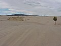
Little Sahara Sand Dunes
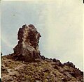
The Great Stone Face
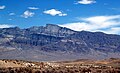
Notch Peak as seen from the south on the valley floor

Topaz Internment Camp


See also
- Cove Fort, Utah
- National Register of Historic Places listings in Millard County, Utah
- USS Millard County (LST-987)
- Willden Fort
References
^ ab "State & County QuickFacts". United States Census Bureau. Archived from the original on July 14, 2011. Retrieved December 29, 2013..mw-parser-output cite.citation{font-style:inherit}.mw-parser-output q{quotes:"""""""'""'"}.mw-parser-output code.cs1-code{color:inherit;background:inherit;border:inherit;padding:inherit}.mw-parser-output .cs1-lock-free a{background:url("//upload.wikimedia.org/wikipedia/commons/thumb/6/65/Lock-green.svg/9px-Lock-green.svg.png")no-repeat;background-position:right .1em center}.mw-parser-output .cs1-lock-limited a,.mw-parser-output .cs1-lock-registration a{background:url("//upload.wikimedia.org/wikipedia/commons/thumb/d/d6/Lock-gray-alt-2.svg/9px-Lock-gray-alt-2.svg.png")no-repeat;background-position:right .1em center}.mw-parser-output .cs1-lock-subscription a{background:url("//upload.wikimedia.org/wikipedia/commons/thumb/a/aa/Lock-red-alt-2.svg/9px-Lock-red-alt-2.svg.png")no-repeat;background-position:right .1em center}.mw-parser-output .cs1-subscription,.mw-parser-output .cs1-registration{color:#555}.mw-parser-output .cs1-subscription span,.mw-parser-output .cs1-registration span{border-bottom:1px dotted;cursor:help}.mw-parser-output .cs1-hidden-error{display:none;font-size:100%}.mw-parser-output .cs1-visible-error{font-size:100%}.mw-parser-output .cs1-subscription,.mw-parser-output .cs1-registration,.mw-parser-output .cs1-format{font-size:95%}.mw-parser-output .cs1-kern-left,.mw-parser-output .cs1-kern-wl-left{padding-left:0.2em}.mw-parser-output .cs1-kern-right,.mw-parser-output .cs1-kern-wl-right{padding-right:0.2em}
^ "Find a County". National Association of Counties. Retrieved 2011-06-07.
^ "Utah: Individual County Chronologies". Utah Atlas of Historical County Boundaries. The Newberry Library. 2008. Retrieved June 26, 2015.
^ Van Atta, Dale (Jan 22, 1977). "You name it - there's a town for it". The Deseret News. p. 15. Retrieved 18 October 2015.
^ "2010 Census Gazetteer Files". United States Census Bureau. August 22, 2012. Retrieved June 25, 2015.
^ "The Great Stone Face, Millard Co", Utah Counties: General Scenery, Utah State Historical Society; J. Willard Marriott Library, University of Utah, retrieved 2014-09-15
^ "Places to see: Utah Historical Sites", UtahOutdoorActivities.com, Utah Outdoor Activities, retrieved 2014-09-15|contribution=ignored (help)
^ Arave, Lynn (May 9, 2010), "Does the Great Stone Face really resemble the Prophet Joseph?", Deseret News
^ Little Sahara Recreation Area.
^ "Annual Estimates of the Resident Population: April 1, 2010 to July 1, 2017". United States Census Bureau. Retrieved May 31, 2018.
^ "U.S. Decennial Census". United States Census Bureau. Retrieved June 25, 2015.
^ "Historical Census Browser". University of Virginia Library. Retrieved June 25, 2015.
^ Forstall, Richard L., ed. (June 25, 1995). "Population of Counties by Decennial Census: 1900 to 1990". United States Census Bureau. Retrieved March 27, 2015.
^ "Census 2000 PHC-T-4. Ranking Tables for Counties: 1990 and 2000" (PDF). United States Census Bureau. April 2, 2001. Retrieved June 25, 2015.
^ "American FactFinder". United States Census Bureau. Retrieved 2011-05-14.
^ Millard County QuickFacts from the US Census Bureau Archived 2011-07-14 at WebCite
^ Census fact finder entry for Millard County
^ Leip, David. "Dave Leip's Atlas of U.S. Presidential Elections". uselectionatlas.org. Retrieved 2018-03-31.
^ Jenson, Andrew (2004). Church Chronology. Kessinger Publishing. p. 54. ISBN 1-4179-6854-0.
External links
| Wikimedia Commons has media related to Millard County, Utah. |
- Official website
Fossils In Millard County, Utah Visits to two world famous fossil localities in Millard County--roughly 505 and 475 million years old, respectively.
Places adjacent to Millard County, Utah | ||||||||||
|---|---|---|---|---|---|---|---|---|---|---|
| ||||||||||
Municipalities and communities of Millard County, Utah, United States | ||
|---|---|---|
County seat: Fillmore | ||
| Cities |
|  |
| Towns |
| |
| CDPs |
| |
| Unincorporated communities |
| |
| Ghost towns |
| |
| Indian reservation |
| |
| Footnotes | ‡This populated place also has portions in an adjacent county or counties | |
Salt Lake City (capital) | |||||||||||||
| Topics |
|  | |||||||||||
| Society |
| ||||||||||||
| Regions |
| ||||||||||||
| Largest cities |
| ||||||||||||
| Counties |
| ||||||||||||
| Attractions |
| ||||||||||||
Coordinates: 39°03′N 113°06′W / 39.05°N 113.10°W / 39.05; -113.10


