Upper Bavaria
Upper Bavaria Oberbayern | |
|---|---|
Regierungsbezirk | |
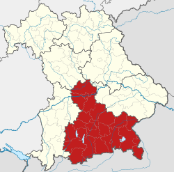 Map of Bavaria highlighting the Regierungsbezirk of Upper Bavaria | |
| Country | Germany |
| State | Bavaria |
| Region seat | Munich |
| Area | |
| • Total | 17,529.41 km2 (6,768.14 sq mi) |
| Population (31 December 2017)[1] | |
| • Total | 4,649,534 |
| • Density | 270/km2 (690/sq mi) |
| Website | regierung.oberbayern.bayern.de |

Coat of arms of Upper Bavaria
Upper Bavaria (German: Oberbayern, Austro-Bavarian: Obabayern) is one of the seven administrative districts of Bavaria, Germany.
Contents
1 Geography
2 Population
3 History
4 Main sights
5 References
6 External links
Geography
Upper Bavaria is located in the southern portion of Bavaria, and is centered on the city of Munich, both state capital and seat of the district government. Because of this, it is by far the most populous administrative division in Bavaria. It is subdivided into four planning regions (Planungsverband): Ingolstadt, Munich, Bayerisches Oberland (Bavarian Highland), and Südostoberbayern (South East Upper Bavaria). It is named 'Upper Bavaria' because the land is higher above sea level than the rest of Bavaria, not because it is farther north.
Landkreise (districts):
- Altötting
- Bad Tölz-Wolfratshausen
- Berchtesgadener Land
- Dachau
- Ebersberg
- Eichstätt
- Erding
- Freising
- Fürstenfeldbruck
- Garmisch-Partenkirchen
- Landsberg
- Miesbach
- Mühldorf
Munich (München)- Neuburg-Schrobenhausen
- Pfaffenhofen
- Rosenheim
- Starnberg
- Traunstein
- Weilheim-Schongau
Kreisfreie Städte (district-free cities):
- Ingolstadt
Munich (München)- Rosenheim
Population
Historical Population of Upper Bavaria:
| Year | Inhabitants |
|---|---|
| 1840 | 711,861 |
| 1871 | 865,178 |
| 1900 | 1,351,086 |
| 1925 | 1,727,483 |
| 1939 | 1,999,048 |
| 1950 | 2,541,896 |
| 1960 | 2,844,910 |
| 1970 | 3,372,700 |
| 1980 | 3,657,776 |
| 1990 | 3,801,448 |
| 2000 | 4,083,077 |
| 2010 | 4,373,588 |
History
The duchy of Upper Bavaria was created for the first time with the First Bavarian partition in 1255 under duke Louis II but there was no exact correlation between this duchy and the current territory. After the reunification in 1340 Bavaria was divided again in 1349, and in 1392 the duchies Bavaria-Munich and Bavaria-Ingolstadt were created in Upper Bavaria. In 1505 Bavaria was permanently reunited. For administrative purposes, Bavaria was split into Rentämter. Upper Bavaria consisted of the Rentamt Munich and Rentamt Burghausen.
After the founding of the Kingdom of Bavaria the state was totally reorganised and, in 1808, divided into 15 administrative districts (Regierungsbezirke (singular Regierungsbezirk)), in Bavaria called (Kreise (singular Kreis)). They were created in the fashion of the French departements, quite even in size and population, and named after their main rivers. In the following years, due to territorial changes (e. g. loss of Tyrol, addition of the Palatinate), the number of districts was reduced to 8. One of these was the Isarkreis (Isar District). In 1837 king Ludwig I of Bavaria renamed the Kreise after historical names and tribes. This also involved border changes or territorial swaps. Thus, the Isarkreis changed to Upper Bavaria.
Instead of a Rentamt-style mere administrational unit, the newly created districts became predecessors of modern regional self-government, building a political and administrational link in-between the Bavarian state as a whole and the local authorities.
Main sights
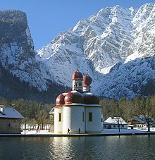
Watzmann East Face, rising behind St. Batholomew's church at lake Königssee
Featured former residence cities are the capital Munich, Ingolstadt and Neuburg an der Donau and the diocesan towns of Freising and Eichstätt. Interesting townscapes are found at Landsberg am Lech, Wasserburg am Inn and Burghausen and further south Bad Reichenhall and Berchtesgaden.
The highest mountain in Upper Bavaria, Zugspitze, offers an incomparable panoramic view of the Alps. Nestled in forested mountain ranges, the lakes Tegernsee, Schliersee, and Spitzingsee, are idyllically situated. The larger lakes, like Starnberger See, Ammersee (south-west of Munich), and Chiemsee further to the east, all situated in the pre-alpine uplands, offer regular Passenger services on steamers.
Sacred art treasures can be found in the monasteries Andechs, Schäftlarn, Fürstenfeld, Benediktbeuern, Polling and Ettal and in the Wieskirche. Among popular excursions in Upper Bavaria are the Koenigssee with the Sanctuary of St Bartholomew's and mount Watzmann, the royal castles of Ludwig II, Linderhof and Herrenchiemsee in Chiemsee, the Burghausen Castle and the castle Hohenaschau. The most important places of pilgrimage are Altoetting and Tuntenhausen.
References
^ "Fortschreibung des Bevölkerungsstandes". Bayerisches Landesamt für Statistik und Datenverarbeitung (in German). September 2018..mw-parser-output cite.citation{font-style:inherit}.mw-parser-output q{quotes:"""""""'""'"}.mw-parser-output code.cs1-code{color:inherit;background:inherit;border:inherit;padding:inherit}.mw-parser-output .cs1-lock-free a{background:url("//upload.wikimedia.org/wikipedia/commons/thumb/6/65/Lock-green.svg/9px-Lock-green.svg.png")no-repeat;background-position:right .1em center}.mw-parser-output .cs1-lock-limited a,.mw-parser-output .cs1-lock-registration a{background:url("//upload.wikimedia.org/wikipedia/commons/thumb/d/d6/Lock-gray-alt-2.svg/9px-Lock-gray-alt-2.svg.png")no-repeat;background-position:right .1em center}.mw-parser-output .cs1-lock-subscription a{background:url("//upload.wikimedia.org/wikipedia/commons/thumb/a/aa/Lock-red-alt-2.svg/9px-Lock-red-alt-2.svg.png")no-repeat;background-position:right .1em center}.mw-parser-output .cs1-subscription,.mw-parser-output .cs1-registration{color:#555}.mw-parser-output .cs1-subscription span,.mw-parser-output .cs1-registration span{border-bottom:1px dotted;cursor:help}.mw-parser-output .cs1-hidden-error{display:none;font-size:100%}.mw-parser-output .cs1-visible-error{font-size:100%}.mw-parser-output .cs1-subscription,.mw-parser-output .cs1-registration,.mw-parser-output .cs1-format{font-size:95%}.mw-parser-output .cs1-kern-left,.mw-parser-output .cs1-kern-wl-left{padding-left:0.2em}.mw-parser-output .cs1-kern-right,.mw-parser-output .cs1-kern-wl-right{padding-right:0.2em}
External links
![]() Media related to Upper Bavaria at Wikimedia Commons
Media related to Upper Bavaria at Wikimedia Commons
Official website Regierung von Oberbayern (in English) (in German)
Official website Bezirk Oberbayern (in German)
Tourism website (in English) (in German)
Administrative regions (Regierungsbezirk) of Bavaria | |||
|---|---|---|---|
| Regions |
| ||
| Former region |
| ||
Coordinates: 48°08′N 11°34′E / 48.133°N 11.567°E / 48.133; 11.567
Authority control |
|
|---|


