Gifhorn (district)
Gifhorn | ||
|---|---|---|
District | ||
| ||
 | ||
| Country | Germany | |
| State | Lower Saxony | |
| Capital | Gifhorn | |
| Area | ||
| • Total | 1,563 km2 (603 sq mi) | |
| Population (31 December 2017)[1] | ||
| • Total | 175,079 | |
| • Density | 110/km2 (290/sq mi) | |
| Time zone | UTC+01:00 (CET) | |
| • Summer (DST) | UTC+02:00 (CEST) | |
| Vehicle registration | GF | |
| Website | www.gifhorn.de | |

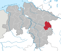
Gifhorn (German pronunciation: [ˈɡɪfhɔʁn]) is a district in Lower Saxony, Germany.
Contents
1 Geography
2 History
3 Coat of arms
4 Towns and municipalities
5 See also
6 References
7 External links
Geography
The district is located at the border of Saxony-Anhalt and extends from the southern edge of the Lüneburg Heath (Lüneburger Heide) in the north to the suburbs of Braunschweig and Wolfsburg in the south. The Aller River enters the district in the southeast, runs through the town of Gifhorn, is joined by the Ise and Oker river and leaves the district in the west. The southern terminus of the Elbe Lateral Canal at the Mittellandkanal is at Edesbüttel in the district.
It is bounded by (from the south and clockwise) the district of Helmstedt, the cities of Wolfsburg and Braunschweig, the districts of Peine, Hanover, Celle and Uelzen, and by the state of Saxony-Anhalt (districts of Altmarkkreis Salzwedel and Börde).
The lowest point of the administrative district Gifhorn lies at the Aller near Müden (46 m above sea level). The highest point lies in the north of the district near Sprakensehl (124 m above sea level).
History
The district was established in 1885 by the Prussian government. In 1932, the former district of Isenhagen became the northern part of the Gifhorn district. The city of Wolfsburg originally was a part of the district, but became a district-free city in 1951. In 1974 the district again lost parts of its territory, when the city of Fallersleben was incorporated into Wolfsburg.
Coat of arms
The lion as well as the hearts are heraldic symbols of Lüneburg - Gifhorn was a part of the duchy of Brunswick-Lüneburg for many centuries and, briefly the Duchy of Gifhorn. The horn symbolises the syllable "horn" in the word Gifhorn.
Towns and municipalities

Map of the Landkreis Gifhorn
(numbers of inhabitants from 30 June 2005)
Communities
Gifhorn, Town, autonomous community (42.658)
Sassenburg (10.946) [Seat: Westerbeck
Wittingen, Town (12.268)
Samtgemeinden with their local communities
* Seat of Samtgemeinde government
|
|
Area without community (uninhabited)
Giebel (10,36 km²)
See also
- Metropolitan region Hannover-Braunschweig-Göttingen-Wolfsburg
References
^ Landesamt für Statistik Niedersachsen, Tabelle 12411: Fortschreibung des Bevölkerungsstandes, Stand 31. Dezember 2017
External links
![]() Media related to Landkreis Gifhorn at Wikimedia Commons
Media related to Landkreis Gifhorn at Wikimedia Commons
Official website (in German)
| Region |
|
|---|---|
| Urban districts |
|
| Rural districts |
|
Coordinates: 52°29′N 10°33′E / 52.483°N 10.550°E / 52.483; 10.550
Authority control |
|
|---|


