Thirunageswaram
Thirunageswaram | |
|---|---|
town panchayat/Sub urban | |
 Rahu Stalam | |
| Country | |
| State | Tamil Nadu |
| District | Thanjavur |
| Government | |
| • Chairman | Kurinja S.Saminathan |
| Population (2001) | |
| • Total | 13,814 |
| Languages | |
| • Official | Tamil |
| Time zone | UTC+5:30 (IST) |
Thirunageswaram is a panchayat town in Thanjavur district in the Indian state of Tamil Nadu. Thirunageswaram is located 6 km east of Kumbakonam. It is the suburban region of business city of Kumbakonam.
Thirunageswaram is one of the many temple towns in the state which is named after the grooves, clusters or forests dominated by a particular variety of a tree or shrub and the same variety of tree or shrub sheltering the presiding deity. The region is believed to have been covered with Chamapaka forest and hence called Chamapakavanam.[1]
Contents
1 Demographics
2 Temples at Thirunageswaram
2.1 Oppliyappan Sannadhi
2.2 Naganatha Swami temple
3 Education
4 Politics
5 References
Demographics
As of 2001[update] India census,[2] Thirunageswaram had a population of 9,814. Males constitute 49% of the population and females 51%. Thirunageswaram has an average literacy rate of 72%, higher than the national average of 59.5%: male literacy is 79%, and female literacy is 65%. In Thirunageswaram, 11% of the population is under 6 years of age.
The town receives a lot of rainfall every year (220 cm) and is known for its extremely fertile land and chief crops include Rice, Wheat and Corn. Coconut and Mango farms are also found in abundance.
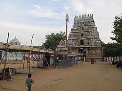
Temples at Thirunageswaram
There are two major temples at Thirunageswaram. One of them is the famous Vaishnavite temple of Oppliyappan (Oppliyappan Sannadhi), the other the Thiru Nageswarar or Naganatha Swami temple for Shaivites.
Oppliyappan Sannadhi
Oppliyappan temple attracts pilgrims throughout the year. Ramanavami is celebrated every year in a grand manner in the months of April/May. Thirukalyanam and Kanakibishekam are the two important events in Ramanavami festival. This temple food is always done without salt in any food. No one should ever take anything that contains salt into this temple.
Naganatha Swami temple
Naganatha Swami (Naga in Tamil/Sanskrit means Snake and Natha means God) is a temple dedicated to Lord Shiva. An important feature of Naganatha Swami temple is that of Rahu bhagawan (one of the nine celestial bodies) sannathi. It is the 29th in the series of Tevara Stalams located south of the river Kaveri. Here milk abhishekam is performed daily during Rahukaalam. At this time, the milk that is poured on the statue turns blue when it passes over the body and once again to white after it reaches the floor. This wonder is watched by many daily during the Raahu Kaalam. This is also the only place wherein one can view Rahu bhagawan with his consorts. The mythological serpents Aadi Seshan, Dakshan and Kaarkotakan worshipped Shiva here. Nala worshipped Shiva here too. Gautama Maharishi, Parashara and Bhageerata are also associated with this temple.
Education
- Government Higher Secondary School.
- Rajamani Matriculation School.
- Tiruvalluvur Primary School.
- Sannapuram Primary School.
- Primary School.
Politics
Tirunageswaram assembly constituency is part of Mayiladuturai (Lok Sabha constituency).
Present MP - Mr. R.K.Bharathi mohan (ADMK)
Present MLA - Mr. Anbazhagan (DMK)
Present President - Mr. S. Saminathan(ADMK).
Thirunageswaram has totally 15 wards.
References
^ Reddy, G.Venkatramana (2013). Alayam - The Hindu temple - An epitome of Hindu Culture. Mylapore, Chennai: Sri Ramakrishna Math. p. 10, 31. ISBN 978-81-7823-542-4..mw-parser-output cite.citation{font-style:inherit}.mw-parser-output .citation q{quotes:"""""""'""'"}.mw-parser-output .citation .cs1-lock-free a{background:url("//upload.wikimedia.org/wikipedia/commons/thumb/6/65/Lock-green.svg/9px-Lock-green.svg.png")no-repeat;background-position:right .1em center}.mw-parser-output .citation .cs1-lock-limited a,.mw-parser-output .citation .cs1-lock-registration a{background:url("//upload.wikimedia.org/wikipedia/commons/thumb/d/d6/Lock-gray-alt-2.svg/9px-Lock-gray-alt-2.svg.png")no-repeat;background-position:right .1em center}.mw-parser-output .citation .cs1-lock-subscription a{background:url("//upload.wikimedia.org/wikipedia/commons/thumb/a/aa/Lock-red-alt-2.svg/9px-Lock-red-alt-2.svg.png")no-repeat;background-position:right .1em center}.mw-parser-output .cs1-subscription,.mw-parser-output .cs1-registration{color:#555}.mw-parser-output .cs1-subscription span,.mw-parser-output .cs1-registration span{border-bottom:1px dotted;cursor:help}.mw-parser-output .cs1-ws-icon a{background:url("//upload.wikimedia.org/wikipedia/commons/thumb/4/4c/Wikisource-logo.svg/12px-Wikisource-logo.svg.png")no-repeat;background-position:right .1em center}.mw-parser-output code.cs1-code{color:inherit;background:inherit;border:inherit;padding:inherit}.mw-parser-output .cs1-hidden-error{display:none;font-size:100%}.mw-parser-output .cs1-visible-error{font-size:100%}.mw-parser-output .cs1-maint{display:none;color:#33aa33;margin-left:0.3em}.mw-parser-output .cs1-subscription,.mw-parser-output .cs1-registration,.mw-parser-output .cs1-format{font-size:95%}.mw-parser-output .cs1-kern-left,.mw-parser-output .cs1-kern-wl-left{padding-left:0.2em}.mw-parser-output .cs1-kern-right,.mw-parser-output .cs1-kern-wl-right{padding-right:0.2em}
^ "Census of India 2001: Data from the 2001 Census, including cities, villages and towns (Provisional)". Census Commission of India. Archived from the original on 16 June 2004. Retrieved 1 November 2008.
Thanjavur district | ||
|---|---|---|
| District headquarters |
|  |
| Country |
| |
| State |
| |
| Region |
| |
| Divisions |
| |
| Taluks |
| |
| Revenue blocks |
| |
| Municipal Corporations |
| |
| Municipalities |
| |
| Rivers |
| |
| History |
| |
| Places of interest |
| |
| Religious and monastic institutions |
| |
| Universities |
| |
| ||


