Pechora River
| Pechora River | |
Russian: Печо́ра; Komi: Печӧра; Nenets: Санэроˮ яха | |
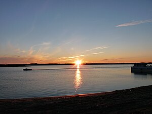 Boat on the Pechora River | |
Name origin: The Russian name of the river is a combination of two words in an old local Nenets dialect, "pe" & "chora". Literally it means "forest dweller".[1] | |
| Country | Russia |
|---|---|
| States | Komi Republic, Nenets Autonomous Okrug |
Tributaries | |
| - left | Izhma River, Neritsa River, Pizhma River, Tsilma River, Sula River, Unya River, Northern Mylva River, Velyu River, Lemyu River, Kozhva River, Lyzha River |
| - right | Ilych River, Podcherye River, Shchugor River, Usa River, Laya River, Ersa River, Soz'va River, Shapkina River, Kuya River |
| Cities | Naryan-Mar, Pechora, Ust-Tsilma |
| Source | Ural Mountains |
| - elevation | 630 m (2,067 ft) |
| - coordinates | 62°12′N 59°26′E / 62.200°N 59.433°E / 62.200; 59.433 |
| Mouth | Arctic Ocean, Pechora Sea / Barents Sea |
| - elevation | 0 ft (0 m) |
| - coordinates | 68°18′N 54°25′E / 68.300°N 54.417°E / 68.300; 54.417Coordinates: 68°18′N 54°25′E / 68.300°N 54.417°E / 68.300; 54.417 |
| Length | 1,809 km (1,124 mi) |
| Basin | 322,000 km2 (124,000 sq mi) |
| Discharge | for mouth (monthly average) |
| - average | 4,100 m3/s (145,000 cu ft/s) [2] |
| - max | 17,182 m3/s (607,000 cu ft/s) |
| - min | 643 m3/s (23,000 cu ft/s) |
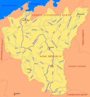 Pechora River catchment area and tributaries | |
The Pechora River (Russian: Печо́ра; Komi: Печӧра; Nenets: Санэроˮ яха) is a river in northwest Russia which flows north into the Arctic Ocean on the west side of the Ural Mountains. It lies mostly in the Komi Republic but the northernmost part crosses the Nenets Autonomous Okrug.
Contents
1 Geography
1.1 Along the Pechora
2 Hydrology
3 Canal projects to the Kama River
4 Literary reference
5 References
Geography
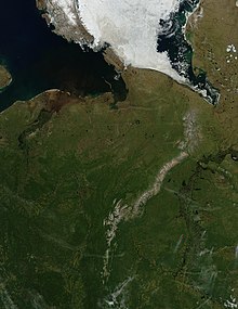
Pechora River, light-colored Ural Mountains and part of the Ob River
It is 1,809 kilometres (1,124 mi) long (a little shorter than the Columbia River) and its basin is 322,000 square kilometres (124,000 sq mi), or about the same size as Finland. By mean annual discharge it ranks third in Europe, after the Volga and Danube.[3] Its discharge is about half that of the Danube and a little more than its sister, the Northern Dvina River, and is the largest of any river with no dams in its basin outside of New Guinea.[3] West of its lower course is the Timan Ridge. East of the basin along the west flank of the Urals is the Yugyd Va National Park. Also in the basin is the Virgin Komi Forests, the largest virgin forest in Europe. In the far northeast of the basin on the Usa River is the large coal center of Vorkuta. The river was once an important transportation route, especially for those travelling to northwest Siberia. Today a railroad runs southwest from Vorkuta to Moscow.
Along the Pechora
The river rises in the Ural Mountains in the south-eastern corner of the Komi Republic. This area is part of the Pechora-Ilych Nature Reserve. On the other side of the Urals are the headwaters of the Northern Sosva River. The river flows south, then west and turns north near Yaksha which is the head of navigation for small boats. A portage led south to the Kama River basin. To the east is the upper Vychegda River, a branch of the Northern Dvina. The river flows past Komsomolsk-na-Pechore to Ust-Ilych where the Ilych River joins from the east, then Northwest to Troitsko-Pechorsk (1,359 kilometres (844 mi) from the mouth), north to Vuktyl and Ust-Shchuger where the Shchugor River joins from the east. The river then flows north to Pechora town, where the railway from Vorkuta crosses, then north to Ust-Usa where the Usa River joins from the east (The Usa was once an important river route into Siberia.). The Pechora then curves northwest, west, and west southwest. Izhma River joins from the south. It then flows further west to Ust-Tsilma (425 kilometres (264 mi) from the mouth) where the Pizhma River (Komi Republic) joins from the southwest and the Tsilma River joins from the west. (Before modern times people traveled up the Tsilma and portaged to the Pyoza River to reach the White Sea.) Then the Pechora turns north and crosses the arctic Arctic Circle and the border of the Nenets Okrug; Pustozyorsk; Naryan-Mar, the Nenets capital and a port at the head of the Pechora delta; Pechora Bay; Pechora Sea; and finally the Barents Sea.
Hydrology
The monthly average discharge of the river was recorded between 1981 to 1993 in the village of Oksino, located 141 km (88 mi) upstream from the mouth. The values are presented in the diagram below (metric units, m3/s).[2]

Canal projects to the Kama River
Before the arrival of the railroad to the Pechora, an important way of travel to the region was via a portage road, from Cherdyn in the Kama River basin to Yaksha on the Pechora.
A project for a Pechora-Kama Canal along the same general route was widely discussed in the 1960s through 1980s, this time not as much for transportation, but for the diversion of some of the water of the Pechora to the Kama, as part of a grand Northern river reversal scheme. However, no construction work was carried out on the route of the proposed canal, other than a triple nuclear explosion in 1971, which excavated a crater over 600 metres (2,000 ft) long.
Literary reference
The Pechora River was the source of the name of Pechorin – protagonist of the 1839 novel A Hero of Our Time by Mikhail Lermontov, a well-known work of Russian literature.
References
Pechora in the Great Soviet Encyclopedia
^ Печора (in Russian). Географическая энциклопедия. Retrieved 2012-03-31..mw-parser-output cite.citation{font-style:inherit}.mw-parser-output q{quotes:"""""""'""'"}.mw-parser-output code.cs1-code{color:inherit;background:inherit;border:inherit;padding:inherit}.mw-parser-output .cs1-lock-free a{background:url("//upload.wikimedia.org/wikipedia/commons/thumb/6/65/Lock-green.svg/9px-Lock-green.svg.png")no-repeat;background-position:right .1em center}.mw-parser-output .cs1-lock-limited a,.mw-parser-output .cs1-lock-registration a{background:url("//upload.wikimedia.org/wikipedia/commons/thumb/d/d6/Lock-gray-alt-2.svg/9px-Lock-gray-alt-2.svg.png")no-repeat;background-position:right .1em center}.mw-parser-output .cs1-lock-subscription a{background:url("//upload.wikimedia.org/wikipedia/commons/thumb/a/aa/Lock-red-alt-2.svg/9px-Lock-red-alt-2.svg.png")no-repeat;background-position:right .1em center}.mw-parser-output .cs1-subscription,.mw-parser-output .cs1-registration{color:#555}.mw-parser-output .cs1-subscription span,.mw-parser-output .cs1-registration span{border-bottom:1px dotted;cursor:help}.mw-parser-output .cs1-hidden-error{display:none;font-size:100%}.mw-parser-output .cs1-visible-error{font-size:100%}.mw-parser-output .cs1-subscription,.mw-parser-output .cs1-registration,.mw-parser-output .cs1-format{font-size:95%}.mw-parser-output .cs1-kern-left,.mw-parser-output .cs1-kern-wl-left{padding-left:0.2em}.mw-parser-output .cs1-kern-right,.mw-parser-output .cs1-kern-wl-right{padding-right:0.2em}
^ ab "Pechora River at Oksino". ArcticNet. Retrieved 2012-03-31.
^ ab Fragmentation and Flow Regulation of the World’s Large River Systems
Authority control |
|
|---|


