Tenaya Canyon
| Tenaya Canyon | |
|---|---|
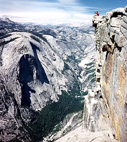 Looking up Tenaya Canyon from the top of Half Dome | |
| Length | 10 miles (16 km) NE to SW |
| Geography | |
| Coordinates | 37°44′32″N 119°33′18″W / 37.7421477°N 119.5548852°W / 37.7421477; -119.5548852Coordinates: 37°44′32″N 119°33′18″W / 37.7421477°N 119.5548852°W / 37.7421477; -119.5548852 |

Upper Tenaya Canyon, view to the north east from Lone Boulder 37°47′9″N 119°29′10″W / 37.78583°N 119.48611°W / 37.78583; -119.48611, above Pywiack Cascade.
Tenaya Canyon is a dramatic and dangerous canyon in Yosemite National Park, California, USA, that runs from the outlet of Tenaya Lake 10 miles down to Yosemite Valley, carrying water in Tenaya Creek through a series of spectacular cascades and pools and thence into a deep canyon below Cloud's Rest, a giant granite mountain adjacent to Half Dome. Waterfalls on the creek inside the canyon include Pywiack Cascade (named for Pywiack Dome) and Three Chute Falls, near Mirror Lake.
The top of the canyon can be seen from Tioga Pass Road (Route 120), which goes through Tuolumne Meadows and Tioga Pass. From Olmsted Point (a roadside viewing area), Clouds Rest and Yosemite's signature Half Dome dominate the canyon. At the bottom of the canyon, in Yosemite Valley, lies Mirror Lake, accessible by shuttle bus and a short walk.
The canyon has no foot trail and is notoriously difficult to navigate, particularly in spring and summer when water levels are high. Signs warn against hiking in the canyon. The American Canyoneering Association gives Tenaya Canyon a rating of 3B V. The 3 is an "intermediate" rating on a scale of 1 to 4, with 4 most difficult; B is a measure of water volume on a scale of A to C; and the V indicates that the trip will take one and a half days.
The canyon has achieved notoriety because of a curse Chief Tenaya reportedly invoked in the 1850s as a result of the death of his son at the hands of a battalion intending to deport the natives of Yosemite Valley. Those who believe in the curse cite accidents, mysterious deaths, and disappearances. For example, in 1996, two hikers died in the canyon.[1] Some park rangers have reportedly referred to Tenaya Canyon as the Bermuda Triangle of Yosemite.[2]
Hiking the canyon involves dangerous exposure to heights, and even if there is minimal water in Tenaya Creek, mandatory swims, dangerous waterfalls, and cascades. Wet and slippery glacially polished granite adds to the likelihood of falling.
References
^ "2 Hikers Killed in Yosemite's Tenaya Canyon". Los Angeles Times. July 7, 1996. Retrieved May 23, 2014..mw-parser-output cite.citation{font-style:inherit}.mw-parser-output q{quotes:"""""""'""'"}.mw-parser-output code.cs1-code{color:inherit;background:inherit;border:inherit;padding:inherit}.mw-parser-output .cs1-lock-free a{background:url("//upload.wikimedia.org/wikipedia/commons/thumb/6/65/Lock-green.svg/9px-Lock-green.svg.png")no-repeat;background-position:right .1em center}.mw-parser-output .cs1-lock-limited a,.mw-parser-output .cs1-lock-registration a{background:url("//upload.wikimedia.org/wikipedia/commons/thumb/d/d6/Lock-gray-alt-2.svg/9px-Lock-gray-alt-2.svg.png")no-repeat;background-position:right .1em center}.mw-parser-output .cs1-lock-subscription a{background:url("//upload.wikimedia.org/wikipedia/commons/thumb/a/aa/Lock-red-alt-2.svg/9px-Lock-red-alt-2.svg.png")no-repeat;background-position:right .1em center}.mw-parser-output .cs1-subscription,.mw-parser-output .cs1-registration{color:#555}.mw-parser-output .cs1-subscription span,.mw-parser-output .cs1-registration span{border-bottom:1px dotted;cursor:help}.mw-parser-output .cs1-hidden-error{display:none;font-size:100%}.mw-parser-output .cs1-visible-error{font-size:100%}.mw-parser-output .cs1-subscription,.mw-parser-output .cs1-registration,.mw-parser-output .cs1-format{font-size:95%}.mw-parser-output .cs1-kern-left,.mw-parser-output .cs1-kern-wl-left{padding-left:0.2em}.mw-parser-output .cs1-kern-right,.mw-parser-output .cs1-kern-wl-right{padding-right:0.2em}
^
Brennen, C.E. "Tenaya Canyon". Adventure Hikes and Canyoneering in the Southwest.
External links
| Wikimedia Commons has media related to Tenaya Canyon. |
"Tenaya Canyon". Geographic Names Information System. United States Geological Survey. Retrieved 2008-11-26.
- A Trip Account