Halim Perdanakusuma International Airport
Halim Perdanakusuma International Airport | |||||||||||
|---|---|---|---|---|---|---|---|---|---|---|---|
| |||||||||||
| Summary | |||||||||||
| Airport type | Public Executive Training Military (Air Force) | ||||||||||
| Operator | PT Angkasa Pura II | ||||||||||
| Serves | Jakarta | ||||||||||
| Location | East Jakarta, Jakarta | ||||||||||
Hub for |
| ||||||||||
| Elevation AMSL | 82 ft / 25 m | ||||||||||
| Coordinates | 06°15′59″S 106°53′28″E / 6.26639°S 106.89111°E / -6.26639; 106.89111Coordinates: 06°15′59″S 106°53′28″E / 6.26639°S 106.89111°E / -6.26639; 106.89111 | ||||||||||
| Website | http://www.halimperdanakusuma-airport.co.id/ | ||||||||||
| Map | |||||||||||
 HLP Location within Jakarta, Indonesia Show map of Jakarta  HLP HLP (Java) Show map of Java  HLP HLP (Indonesia) Show map of Indonesia  HLP HLP (Southeast Asia) Show map of Southeast Asia | |||||||||||
Runways | |||||||||||
| |||||||||||
| Statistics (2016) | |||||||||||
| |||||||||||
Sources: List of the busiest airports in Indonesia | |||||||||||
Halim Perdanakusuma International Airport (Indonesian: Bandar Udara Internasional Halim Perdanakusuma) (IATA: HLP, ICAO: WIHH) is an international airport in Jakarta, Indonesia.[1] The airport is located at East Jakarta.
Aside from commercial scheduled flights, this airport is also used for military, private and presidential purposes. The airport is used for corporate aviation with frequent arrivals and departures of corporate aircraft both domestically and internationally. About 5.6 million passengers used the airport in 2016.
Contents
1 History
2 Terminals
2.1 Main Terminal
2.2 Presidential Terminal
3 Airlines and destinations
3.1 Passenger
3.2 Cargo
4 SHIA to HPIA express rail link
5 Accidents and Incidents
6 References
7 External links
History
This airport takes its name from Air Vice-Marshal Halim Perdanakusuma, an Indonesian aviator. It is now home to a large number of turboprop, charter, and general aviation companies. It is a major air force base of the Indonesian Air Force and is home to most of its major squadrons, such as the 31st Squadron and the 17th VIP Squadron.
In the 1960s, it was also known as the Halim Perdana Kusumah Air Force Base, and before that it was known as Tjililitan Airport or Tjililitan Airfield (Dutch: Vliegveld Tjililitan), after its borough.
As a civilian airport, Halim Perdanakusuma was one the city's main airports, along with Kemayoran Airport, until the opening of Soekarno–Hatta International Airport in Tangerang in 1985. Until then, it served all international routes bound for Jakarta, while Kemayoran handled domestic flights. The closure of Kemayoran in 1985 meant that Halim would serve as the secondary airport of Jakarta, mostly handling charter flights, general aviation, and flying school base for the next 29 years. In the 1990s the Directorate General of Civil Aviation mandated that Halim would serve non-scheduled flights, as well as scheduled flights with aircraft under 100 passengers capacity.
To ease Soekarno–Hatta International Airport, the Halim airport authority has announced to give 60 flight slots per hour for scheduled flights and, for the first time, the 2013 Haj pilgrims used this airport.[2] Since 2014, the airport serves domestic scheduled flights with limitation capacity up to 2.2 million passengers per year from about 200,000 passengers in 2013 (over capacity).[3]
In 2014, Halim reopened for all scheduled flights as a congestion reliever for the overcrowded Soekarno–Hatta airport. An Airport Express train was planned to connect the airport to Soekarno–Hatta International Airport. A feasibility study was conducted in December 2013. On January 10, 2014, Halim Perdanakusuma began to serve domestic scheduled commercial flights to ease the overloaded Soekarno–Hatta International Airport.[4] Initially Citilink was the largest user, taking 32 slots from 74 slots available for all airlines a day.[5]
Terminals
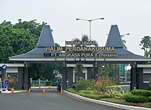
Entrance of Halim Perdanakusuma Airport
Main Terminal
This terminal serves for all departing and arriving flights. It operates for domestic flights only.
Presidential Terminal
This terminal is used solely by the President of the Republic of Indonesia and other government VIP flights.
Airlines and destinations
Passenger
| Airlines | Destinations |
|---|---|
| Batik Air | Ambon, Balikpapan, Banda Aceh, Bandar Lampung, Batam, Bengkulu, Denpasar/Bali, Kupang, Makassar, Malang, Mataram–Lombok, Medan, Padang, Palembang, Pekanbaru, Pontianak, Samarinda, Semarang, Surakarta/Solo, Surabaya, Yogyakarta |
| Citilink | Denpasar/Bali, Malang, Mataram–Lombok, Medan, Padang, Palembang, Semarang, Silangit, Surakarta/Solo, Surabaya, Yogyakarta |
| Pelita Air | Charter: Cilacap, Dumai, Matak |
| Susi Air | Cilacap, Pangandaran |
| TransNusa | Charter: Cilacap,[6]Matak |
| Wings Air | Bandung, Tasikmalaya |
Cargo
| Airlines | Destinations |
|---|---|
| Cardig Air | Balikpapan, Singapore |
| Tri-MG Intra Asia Airlines | Balikpapan, Singapore |
SHIA to HPIA express rail link
.mw-parser-output .RMbox{box-shadow:0 2px 2px 0 rgba(0,0,0,.14),0 1px 5px 0 rgba(0,0,0,.12),0 3px 1px -2px rgba(0,0,0,.2)}.mw-parser-output .RMinline{float:none;width:100%;margin:0;border:none}.mw-parser-output table.routemap{padding:0;border:0;border-spacing:0;background:transparent;white-space:nowrap;line-height:1.2;margin:auto}.mw-parser-output .RMir{border:0;border-spacing:0;display:table;line-height:0;padding:0!important;margin:0 auto!important}.mw-parser-output table.routemap .RMsi{display:inline;font-size:90%}.mw-parser-output table.routemap .RMl1{padding:0 3px;text-align:left}.mw-parser-output table.routemap .RMr1{padding:0 3px;text-align:right}.mw-parser-output table.routemap .RMl{text-align:right}.mw-parser-output table.routemap .RMr{text-align:left}.mw-parser-output table.routemap .RMl4{padding:0 3px 0 0;text-align:left}.mw-parser-output table.routemap .RMr4{padding:0 0 0 3px;text-align:right}.mw-parser-output table.routemap>tbody>tr{line-height:1}.mw-parser-output table.routemap>tbody>tr>td{padding:0;width:auto;vertical-align:middle;text-align:center}.mw-parser-output .RMir>tbody>tr{display:inline-table}.mw-parser-output .RMir>tbody>tr>td{padding:0;height:20px;min-height:20px}.mw-parser-output .RMir .RMov{position:relative}.mw-parser-output .RMir .RMic{position:absolute;left:0px;top:0px;padding:0}.mw-parser-output .RMir .RMtx{line-height:20px;vertical-align:middle;text-align:center}.mw-parser-output .RMir .RMsp{height:20px;min-height:20px}.mw-parser-output .RMir div>.RMtx{position:absolute}.mw-parser-output .RMir .RMtx>abbr,.mw-parser-output .RMir .RMtx>div{line-height:.975;display:inline-block;vertical-align:middle}.mw-parser-output .RMir .RMf_{height:5px;min-height:5px;width:20px;min-width:20px}.mw-parser-output .RMir .RMfm{height:100%;min-height:100%;width:4px;min-width:4px;margin:0 auto}.mw-parser-output .RMir .RMo{width:2.5px;min-width:2.5px}.mw-parser-output .RMir .RMc{width:5px;min-width:5px}.mw-parser-output .RMir .RMoc{width:7.5px;min-width:7.5px}.mw-parser-output .RMir .RMd{width:10px;min-width:10px}.mw-parser-output .RMir .RMod{width:12.5px;min-width:12.5px}.mw-parser-output .RMir .RMcd{width:15px;min-width:15px}.mw-parser-output .RMir .RMocd{width:17.5px;min-width:17.5px}.mw-parser-output .RMir .RM_{width:20px;min-width:20px}.mw-parser-output .RMir .RM_o{width:22.5px;min-width:22.5px}.mw-parser-output .RMir .RM_c{width:25px;min-width:25px}.mw-parser-output .RMir .RM_oc{width:27.5px;min-width:27.5px}.mw-parser-output .RMir .RM_d{width:30px;min-width:30px}.mw-parser-output .RMir .RM_od{width:32.5px;min-width:32.5px}.mw-parser-output .RMir .RM_cd{width:35px;min-width:35px}.mw-parser-output .RMir .RM_ocd{width:37.5px;min-width:37.5px}.mw-parser-output .RMir .RMb{width:40px;min-width:40px}.mw-parser-output .RMir .RMcb{width:45px;min-width:45px}.mw-parser-output .RMir .RMdb{width:50px;min-width:50px}.mw-parser-output .RMir .RMcdb{width:55px;min-width:55px}.mw-parser-output .RMir .RM_b{width:60px;min-width:60px}.mw-parser-output .RMir .RM_cb{width:65px;min-width:65px}.mw-parser-output .RMir .RM_db{width:70px;min-width:70px}.mw-parser-output .RMir .RM_cdb{width:75px;min-width:75px}.mw-parser-output .RMir .RMs{width:80px;min-width:80px}.mw-parser-output .RMir .RMds{width:90px;min-width:90px}.mw-parser-output .RMir .RM_s{width:100px;min-width:100px}.mw-parser-output .RMir .RM_ds{width:110px;min-width:110px}.mw-parser-output .RMir .RMbs{width:120px;min-width:120px}.mw-parser-output .RMir .RMdbs{width:130px;min-width:130px}.mw-parser-output .RMir .RM_bs{width:140px;min-width:140px}.mw-parser-output .RMir .RM_dbs{width:150px;min-width:150px}.mw-parser-output .RMir .RMw{width:160px;min-width:160px}.mw-parser-output .RMir .RM_w{width:180px;min-width:180px}.mw-parser-output .RMir .RMbw{width:200px;min-width:200px}.mw-parser-output .RMir .RM_bw{width:220px;min-width:220px}.mw-parser-output .RMir .RMsw{width:240px;min-width:240px}.mw-parser-output .RMir .RM_sw{width:260px;min-width:260px}.mw-parser-output .RMir .RMbsw{width:280px;min-width:280px}.mw-parser-output .RMir .RM_bsw{width:300px;min-width:300px}
Soekarno–Hatta ARS | ||||||||||||||||||||||||||||||||||||||||||||||||||||||||||||||||||||||||||||||||||||||||||||||||||||||||||||||||||||||||||||
|---|---|---|---|---|---|---|---|---|---|---|---|---|---|---|---|---|---|---|---|---|---|---|---|---|---|---|---|---|---|---|---|---|---|---|---|---|---|---|---|---|---|---|---|---|---|---|---|---|---|---|---|---|---|---|---|---|---|---|---|---|---|---|---|---|---|---|---|---|---|---|---|---|---|---|---|---|---|---|---|---|---|---|---|---|---|---|---|---|---|---|---|---|---|---|---|---|---|---|---|---|---|---|---|---|---|---|---|---|---|---|---|---|---|---|---|---|---|---|---|---|---|---|---|---|
| ||||||||||||||||||||||||||||||||||||||||||||||||||||||||||||||||||||||||||||||||||||||||||||||||||||||||||||||||||||||||||||
The feasibility study of an airport-to-airport Express Train has been finished and ready for prequalification offering. The Express Train initial plan is from Soekarno–Hatta International Airport (SHIA) to Manggarai, but to realize needs of transportation from Halim Perdanakusuma Airport (HPA), the route is extended from Manggarai to HPA. The route will stretch 33 kilometers, from Halim-Cawang-Manggarai-Tanah Abang-Sudirman-Pluit-Terminal 2&3 SHIA, on surface, underground and elevated, and has been agreed by Peraturan Menteri Nomor 1264 Tahun 2013 of Transportation Ministry. The Express Train takes 30 minutes to travel between two airports instead of a 1 to 3 hours drive.[7]
Accidents and Incidents
- On 24 June 1982, British Airways Flight 9, a Boeing 747-200 flew through a cloud of volcanic ash thrown up by the eruption of Mount Galunggung, causing the failure of all four engines. The crew diverted the aircraft to Jakarta and it landed safely.
- On 21 June 2012, an Indonesian Air Force Fokker F-27 crashed on landing and hit a housing complex near Halim airport.[8]
- On 4 April 2016, Batik Air Flight 7703, a Boeing 737-800 registration PK-LBS, collided with a TransNusa ATR 42 while taxiing. The Boeing 737 wingtip sliced the tail of the ATR. The wingtip of the Boeing 737 burst into flames but was quickly extinguished. No one on board were killed.[9]

President of the Philippines, Rodrigo Duterte, walks past Indonesian honor guards at the airport

Citilink Airbus A320-200 taxiing at Halim

The arrival hall of the old Tjililitan airfield in 1915–1925

The old Tjililitan airfield in 1925–1935

A Fokker F.VII plane at Tjililitan in 1929


References
^ "Soekarno–Hatta must be expanded to meet passenger demand" Archived 17 August 2015 at WebCite. The Jakarta Post. Wednesday 1 September 2010. Retrieved on 16 September 2010.
^ "Halim undergoes renovation to ease air traffic at Soekarno–Hatta". July 24, 2013..mw-parser-output cite.citation{font-style:inherit}.mw-parser-output q{quotes:"""""""'""'"}.mw-parser-output code.cs1-code{color:inherit;background:inherit;border:inherit;padding:inherit}.mw-parser-output .cs1-lock-free a{background:url("//upload.wikimedia.org/wikipedia/commons/thumb/6/65/Lock-green.svg/9px-Lock-green.svg.png")no-repeat;background-position:right .1em center}.mw-parser-output .cs1-lock-limited a,.mw-parser-output .cs1-lock-registration a{background:url("//upload.wikimedia.org/wikipedia/commons/thumb/d/d6/Lock-gray-alt-2.svg/9px-Lock-gray-alt-2.svg.png")no-repeat;background-position:right .1em center}.mw-parser-output .cs1-lock-subscription a{background:url("//upload.wikimedia.org/wikipedia/commons/thumb/a/aa/Lock-red-alt-2.svg/9px-Lock-red-alt-2.svg.png")no-repeat;background-position:right .1em center}.mw-parser-output .cs1-subscription,.mw-parser-output .cs1-registration{color:#555}.mw-parser-output .cs1-subscription span,.mw-parser-output .cs1-registration span{border-bottom:1px dotted;cursor:help}.mw-parser-output .cs1-hidden-error{display:none;font-size:100%}.mw-parser-output .cs1-visible-error{font-size:100%}.mw-parser-output .cs1-subscription,.mw-parser-output .cs1-registration,.mw-parser-output .cs1-format{font-size:95%}.mw-parser-output .cs1-kern-left,.mw-parser-output .cs1-kern-wl-left{padding-left:0.2em}.mw-parser-output .cs1-kern-right,.mw-parser-output .cs1-kern-wl-right{padding-right:0.2em}
^ "Layani Penerbangan Komersial, Bandara Halim Kebut Renovasi". December 21, 2013.
^ "Citilink Berangkat Dari Halim Penuh Penumpang". January 10, 2014.
^ Robertus Belarminus (June 3, 2014). "Tiga Maskapai Batal Beroperasi di Halim Perdanakusuma".
^ https://satelitpost.com/beritautama/penerbangan-perdana-maskapai-transnusa-cilacap-semarang-hanya-55-menit
^ "April, Tender Kereta Halim-Bandara Soekarno-Hatta". Retrieved January 13, 2014.
^ [1]
^ "Accident: Batik B738 and Transnusa AT42 at Jakarta on Apr 4th 2016, ground collision, both aircraft on fire". AVHerald. Retrieved 4 April 2016.
External links
| Wikimedia Commons has media related to Halim Perdanakusuma Airport. |
PT. Angkasa Pura II: Halim Perdanakusuma Airport (in English)
Airport information for WIHH at World Aero Data. Data current as of October 2006.Source: DAFIF.
Current weather for WIHH at NOAA/NWS
Airport information for HLP at Great Circle Mapper. Source: DAFIF (effective October 2006).
Accident history for HLP at Aviation Safety Network


