Lesser Poland Voivodeship
Lesser Poland Voivodeship Województwo małopolskie | |||
|---|---|---|---|
Voivodeship | |||
| |||
 Location within Poland | |||
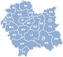 Division into counties | |||
| Coordinates (Kraków): 50°3′41″N 19°56′18″E / 50.06139°N 19.93833°E / 50.06139; 19.93833 | |||
| Country | |||
| Capital | Kraków | ||
| Counties | 3 cities, 19 land counties *
| ||
| Area | |||
| • Total | 15,108 km2 (5,833 sq mi) | ||
| Population (31 March 2014) | |||
| • Total | 3,406,000 | ||
| • Density | 230/km2 (580/sq mi) | ||
| • Urban | 1,619,235 | ||
| • Rural | 1,648,496 | ||
| Car plates | K | ||
HDI (2017) | 0.876[1] very high · 2nd | ||
| Website | http://www.malopolskie.pl/ | ||
| |||


Lesser Poland Voivodeship or Lesser Poland Province (in Polish: województwo małopolskie [vɔjɛˈvut͡stfɔ mawɔˈpɔlskʲɛ]), also known as Małopolska Voivodeship or Małopolska Province,[2] is a voivodeship (province), in southern Poland. It has an area of 15,108 square kilometres (5,833 sq mi), and a population of 3,267,731 (2006).
It was created on 1 January 1999 out of the former Kraków, Tarnów, Nowy Sącz and parts of Bielsko-Biała, Katowice, Kielce and Krosno Voivodeships, pursuant to the Polish local government reforms adopted in 1998. The province's name recalls the traditional name of a historic Polish region, Lesser Poland, or in Polish: Małopolska. Current Lesser Poland Voivodeship, however, covers only a small part of the broader ancient Małopolska region which, together with Greater Poland (Wielkopolska) and Silesia (Śląsk), formed the early medieval Polish state. Historic Lesser Poland is much larger than the current province. It stretches far north, to Radom, and Siedlce, also including such cities, as Stalowa Wola, Lublin, Kielce, Częstochowa, and Sosnowiec.
The province is bounded on the north by the Świętokrzyskie Mountains (Góry Świętokrzyskie), on the west by Jura Krakowsko-Częstochowska (a broad range of hills stretching from Kraków to Częstochowa), and on the south by the Tatra,
Pieniny and Beskidy Mountains. Politically it is bordered by Silesian Voivodeship to the west, Świętokrzyskie Voivodeship to the north, Subcarpathian Voivodeship to the east, and Slovakia (Prešov Region and Žilina Regions) to the south.
Almost all of Lesser Poland lies in the Vistula River catchment area. The city of Kraków was one of the European Cities of Culture in 2000. Kraków has railway and road connections with Katowice (expressway), Warsaw, Wrocław and Rzeszów. It lies at the crossroads of major international routes linking Dresden with Kiev, and Gdańsk with Budapest. Located here is the second largest international airport in Poland (after Warsaw's), the John Paul II International Airport.
Contents
1 Economy
2 Universities
3 Climate
4 Tourism
5 List of cities and towns
6 Administrative division
7 Protected areas
8 Symbols
9 Most popular surnames in the region
10 See also
11 Notes
12 References
Economy
The region's economy includes high technology, banking, chemical and metallurgical industries, coal, ore, food processing, and spirit and tobacco industries. The most industrialized city of the voivodeship is Kraków. The largest regional enterprise operates here, the Tadeusz Sendzimir Steelworks in Nowa Huta, employing 17,500 people. Another major industrial center is located in the west, in the neighborhood of Chrzanów (chiefly the production of railway engines) and Oświęcim (chemical works). Kraków Park Technologiczny, a Special Economic Zone, has been established within the voivodeship. There are almost 210,000 registered economic entities operating in the voivodeship, mostly small and medium-sized, of which 234 belong to the state-owned sector. Foreign investment, growing in the region, reached approximately US$18.3 billion by the end of 2006.
Universities
130,000 students attend fifteen Kraków institutions of higher learning. The Jagiellonian University, the largest university in the city (44,200 students), was founded in 1364 as Cracow Academy. Nicolaus Copernicus and Karol Wojtyła (Pope John Paul II) graduated from it. The AGH University of Science and Technology (29,800 students) is considered to be the best technical university in Poland. The Academy of Economics, the Pedagogical University, the Kraków University of Technology and the Agricultural Academy are also very highly regarded. There are also the Fine Arts Academy, the State Theatre University and the Musical Academy. Nowy Sącz has become a major educational center in the region thanks to its Higher School of Business and Administration, with an American curriculum, founded in 1992. The school has 4,500 students. There are also two private higher schools in Tarnów.
Climate
Located in Southern Poland, Lesser Poland is the warmest place in Poland with average summer temperatures between 23 °C (73.4 °F) and 30 °C (86 °F) during the day, often reaching 32 °C (89.6 °F) to 38 °C (100.4 °F) in July and August, the two warmest months of the year. The city of Tarnów, which is located in Lesser Poland, is the hottest place in Poland all year round, average temperatures being around 25 °C (77 °F) during the day in the three summer months and 3 °C (37.4 °F) during the day in the three winter months. In the winter the weather patterns alter each year; usually winters are mildly cold with temperatures ranging from -7 °C (19.4 °F)to 4 °C (39.2 °F), but the winter season changes often to a more humid and warmer winter, or more continental and cold, depending on the many various wind patterns that affect Poland from different regions of the world. Błędów Desert, the only desert in Poland, is located in Lesser Poland, where temperatures can often reach up to 38 °C (100.4 °F) in the summer.
Tourism

The Wieliczka Salt Mine is a UNESCO World Heritage Site
Four national parks and numerous reserves have been established in the voivodeship to protect the environment of Lesser Poland. The region has areas for tourism and recreation, including Zakopane (Poland's most popular winter resort) and the Tatra, Pieniny and Beskidy Mountains. The natural landscape features many historic sites. The salt mine at Wieliczka, the pilgrimage town of Kalwaria Zebrzydowska, and Kraków's Old Town are ranked by UNESCO among the most precious sites of world heritage. At Wadowice, birthplace of John Paul II (50 kilometers southwest of Kraków) is a museum dedicated to the late Pope's childhood. The area of Oświęcim, with the former Nazi concentration camps Auschwitz-I and Auschwitz-II-Birkenau, is visited annually by a million people. Another tourist destination is the town of Bochnia with its salt mine, Europe's oldest.
List of cities and towns

Kraków, capital of Lesser Poland

Tarnów
Nowy Sącz

Oświęcim

Chrzanów

Olkusz

Nowy Targ

Bochnia
The voivodeship contains 61 cities and towns. These are listed below in descending order of population (according to official figures for 2006[3] ):
Kraków (756,757)
Tarnów (117,109)
Nowy Sącz (84,594)
Oświęcim (40,979)
Chrzanów (39,797)
Olkusz (37,552)
Nowy Targ (33,493)
Bochnia (29,373)
Gorlice (28,539)
Zakopane (27,486)
Skawina (23,691)
Andrychów (21,691)
Kęty (19,252)
Wadowice (19,149)
Wieliczka (19,133)
Trzebinia (18,769)
Myślenice (18,070)
Libiąż (17,604)
Brzesko (16,827)
Limanowa (14,632)
Rabka-Zdrój (13,031)
Brzeszcze (11,730)
Miechów (11,717)
Dąbrowa Tarnowska (11,259)
Krynica-Zdrój (11,243)
Bukowno (10,695)
Krzeszowice (9,942)
Sucha Beskidzka (9,726)
Wolbrom (9,075)
Chełmek (9,065)
Stary Sącz (8,987)
Niepołomice (8,537)
Mszana Dolna (7,529)
Szczawnica (7,334)
Tuchów (6,501)
Sułkowice (6,305)
Proszowice (6,205)
Dobczyce (6,028)
Grybów (6,025)
Maków Podhalański (5,738)
Piwniczna-Zdrój (5,717)
Jordanów (5,112)
Muszyna (4,980)
Biecz (4,585)
Kalwaria Zebrzydowska (4,503)
Słomniki (4,331)
Żabno (4,271)
Szczucin (4,069)
Zator (3,726)
Skała (3,693)
Alwernia (3,406)
Wojnicz (3,404)
Bobowa (3,018)
Radłów (c. 2,800)
Ryglice (2,784)
Nowy Wiśnicz (2,716)
Ciężkowice (2,378)
Czchów (2,207)
Świątniki Górne (2,101)
Nowe Brzesko (c. 1,700)
Zakliczyn (1,556)
Administrative division
Smaller Poland Voivodeship is divided into 22 counties (powiats): 3 city counties and 19 land counties. These are further divided into 182 gminas.
The counties are listed in the following table (ordering within categories is by decreasing population).
English and Polish names | Area (km²) | Population (2006) | Seat | Other towns | Total gminas |
City counties | |||||
Kraków | 327 | 756,757 | 1 | ||
Tarnów | 72 | 117,109 | 1 | ||
Nowy Sącz | 57 | 84,594 | 1 | ||
Land counties | |||||
Kraków County powiat krakowski | 1,230 | 244,970 | Kraków * | Skawina, Krzeszowice, Słomniki, Skała, Świątniki Górne | 17 |
Nowy Sącz County powiat nowosądecki | 1,550 | 197,718 | Nowy Sącz * | Krynica-Zdrój, Stary Sącz, Grybów, Piwniczna-Zdrój, Muszyna | 16 |
Tarnów County powiat tarnowski | 1,413 | 193,549 | Tarnów * | Tuchów, Żabno, Wojnicz, Radłów, Ryglice, Ciężkowice, Zakliczyn | 16 |
Nowy Targ County powiat nowotarski | 1,475 | 181,878 | Nowy Targ | Rabka-Zdrój, Szczawnica | 14 |
Wadowice County powiat wadowicki | 646 | 154,304 | Wadowice | Andrychów, Kalwaria Zebrzydowska | 10 |
Oświęcim County powiat oświęcimski | 406 | 153,390 | Oświęcim | Kęty, Brzeszcze, Chełmek, Zator | 9 |
Chrzanów County powiat chrzanowski | 371 | 128,103 | Chrzanów | Trzebinia, Libiąż, Alwernia | 5 |
Limanowa County powiat limanowski | 952 | 121,658 | Limanowa | Mszana Dolna | 12 |
Myślenice County powiat myślenicki | 673 | 116,793 | Myślenice | Sułkowice, Dobczyce | 9 |
Olkusz County powiat olkuski | 622 | 114,286 | Olkusz | Bukowno, Wolbrom | 6 |
Gorlice County powiat gorlicki | 967 | 106,540 | Gorlice | Biecz, Bobowa | 10 |
Wieliczka County powiat wielicki | 428 | 105,266 | Wieliczka | Niepołomice | 5 |
Bochnia County powiat bocheński | 649 | 100,382 | Bochnia | Nowy Wiśnicz | 9 |
Brzesko County powiat brzeski | 590 | 90,214 | Brzesko | Czchów | 7 |
Sucha County powiat suski | 686 | 82,045 | Sucha Beskidzka | Maków Podhalański, Jordanów | 9 |
Tatra County powiat tatrzański | 472 | 65,393 | Zakopane | 5 | |
Dąbrowa County powiat dąbrowski | 530 | 58,572 | Dąbrowa Tarnowska | Szczucin | 7 |
Miechów County powiat miechowski | 677 | 50,769 | Miechów | 7 | |
Proszowice County powiat proszowicki | 415 | 43,441 | Proszowice | Nowe Brzesko | 6 |
| * seat not part of the county | |||||
Protected areas

Czarny Staw in the High Tatras

The spa town of Szczawnica in the Pieniny Mountains
Protected areas in Lesser Poland Voivodeship include six National Parks and 11 Landscape Parks. These are listed below.
Babia Góra National Park (a UNESCO-designated biosphere reserve)- Gorce National Park
Magura National Park (partly in Subcarpathian Voivodeship)- Ojców National Park
- Pieniny National Park
Tatra National Park (part of a UNESCO biosphere reserve shared with Slovakia)- Bielany-Tyniec Landscape Park
- Ciężkowice-Rożnów Landscape Park
- Dłubnia Landscape Park
Eagle Nests Landscape Park (partly in Silesian Voivodeship)- Kraków Valleys Landscape Park
Little Beskids Landscape Park (partly in Silesian Voivodeship)
Pasmo Brzanki Landscape Park (partly in Subcarpathian Voivodeship)- Poprad Landscape Park
- Rudno Landscape Park
- Tenczynek Landscape Park
- Wiśnicz-Lipnica Landscape Park
Symbols
Smaller Poland Voivodeship's symbols can be blazoned as follows:
Coat of arms:
A traditional Iberian shield gules, an eagle argent displayed armed, legged, beaked, langued and crowned Or.
Flag:
Per fess argent and gules, a narrow fess Or.
Most popular surnames in the region
Nowak: 23,671
Wójcik: 13,347
Zając: 10,206
See also
Second Polish Republic’s Kraków Voivodeship (1919–1939)
- Lesser Polish Way
Notes
^ "Sub-national HDI - Area Database - Global Data Lab". hdi.globaldatalab.org. Retrieved 2018-09-13..mw-parser-output cite.citation{font-style:inherit}.mw-parser-output q{quotes:"""""""'""'"}.mw-parser-output code.cs1-code{color:inherit;background:inherit;border:inherit;padding:inherit}.mw-parser-output .cs1-lock-free a{background:url("//upload.wikimedia.org/wikipedia/commons/thumb/6/65/Lock-green.svg/9px-Lock-green.svg.png")no-repeat;background-position:right .1em center}.mw-parser-output .cs1-lock-limited a,.mw-parser-output .cs1-lock-registration a{background:url("//upload.wikimedia.org/wikipedia/commons/thumb/d/d6/Lock-gray-alt-2.svg/9px-Lock-gray-alt-2.svg.png")no-repeat;background-position:right .1em center}.mw-parser-output .cs1-lock-subscription a{background:url("//upload.wikimedia.org/wikipedia/commons/thumb/a/aa/Lock-red-alt-2.svg/9px-Lock-red-alt-2.svg.png")no-repeat;background-position:right .1em center}.mw-parser-output .cs1-subscription,.mw-parser-output .cs1-registration{color:#555}.mw-parser-output .cs1-subscription span,.mw-parser-output .cs1-registration span{border-bottom:1px dotted;cursor:help}.mw-parser-output .cs1-hidden-error{display:none;font-size:100%}.mw-parser-output .cs1-visible-error{font-size:100%}.mw-parser-output .cs1-subscription,.mw-parser-output .cs1-registration,.mw-parser-output .cs1-format{font-size:95%}.mw-parser-output .cs1-kern-left,.mw-parser-output .cs1-kern-wl-left{padding-left:0.2em}.mw-parser-output .cs1-kern-right,.mw-parser-output .cs1-kern-wl-right{padding-right:0.2em}
^ Arkadiusz Belczyk, Tłumaczenie polskich nazw geograficznych na język angielski Archived 2016-03-03 at the Wayback Machine. [Translation of Polish Geographical Names into English], 2002-2006.
^ "Archived copy". Archived from the original on May 5, 2008. Retrieved August 9, 2008.CS1 maint: Archived copy as title (link)
References
| Wikimedia Commons has media related to Lesser Poland Voivodeship. |
| Wikivoyage has a travel guide for Lesser Poland Voivodeship. |
- Małopolskie Voivodship Official Site
- Photo- and Topographic Maps of the whole region
- https://web.archive.org/web/20071013013150/http://travel.poland.com/texts/en/t-ap-2.php
- Agency for Regional Development of Lesser Poland - MARR
- Tourism Information of Małopolskie Voivodship
- Małopolska Province invites
General statistics[permanent dead link]
- Photos of Krakow, Tatry, Zakopane
- Info about the Smaller Poland - Malopolska Province
Counties of Lesser Poland Voivodeship | ||
|---|---|---|
| City counties |
|  |
| Land counties |
| |
Voivodeships of Poland | ||
|---|---|---|
| ||
Coordinates: 49°51′34″N 20°16′29″E / 49.85944°N 20.27472°E / 49.85944; 20.27472
Authority control |
|
|---|


