Minyip
Minyip Victoria | |
|---|---|
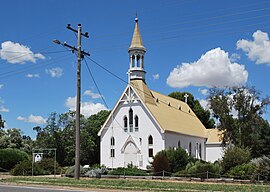 St John's Lutheran church, Minyip | |
 Minyip | |
| Coordinates | 36°27′S 142°35′E / 36.450°S 142.583°E / -36.450; 142.583Coordinates: 36°27′S 142°35′E / 36.450°S 142.583°E / -36.450; 142.583 |
| Population | 524 (2016 census)[1] |
| Established | 1870s |
| Postcode(s) | 3392 |
| Location |
|
| LGA(s) | Shire of Yarriambiack |
| State electorate(s) | Lowan |
| Federal Division(s) | Mallee |
Minyip is a town in the Wimmera region of Victoria, Australia, 320 kilometres (199 mi) north west of Melbourne. It is in the Shire of Yarriambiack local government area. At the 2016 census, Minyip had a population of 524.[1]
The name "Minyip" is derived from the Aboriginal word for "Ashes".[2]
The town is known as the "Heart of the Wheat belt".[citation needed] Dryland agriculture especially grain production and handling is one of the region's major industries.
Contents
1 History
1.1 St John's Lutheran Church
2 Today
3 Gallery
4 References
5 External links
History
The area was first settled by European selectors in the 1870s. The town became a railhead when the railway arrived from Murtoa in 1886. A grain shed was used to store local wheat until silos were built in 1939-40.
The town's courthouse dates from 1886 and the old office of the local newspaper The Guardian (1885) has been converted into an historical research centre by the local historical society. The Club Hotel (1907) and the Commercial Hotel (1908) are Edwardian buildings with wrought-iron lacework and leadlight windows. Violet's General Store dates from 1897.[3]
Minyip Post Office opened on 1 May 1875.[4]
St John's Lutheran Church
The German Lutherans, fleeing religious persecution, came to the area around Minyip in the mid-to-late nineteenth century. One group formed at the tiny village of Kirchheim, 6 kilometres (3.7 mi) south-west of Minyip. They built a weatherboard church there in 1875 but it was destroyed by a violent storm in 1889. This led to the construction, in that same year, of the present timber building. In 1935 this building, which had an estimated weight of 50 tons, was moved by steam traction engine to its present site on the corner of Church and Carrol Streets. It took three days to move the structure the 6 kilometres (3.7 mi) from its original foundations. On the way it very nearly toppled over when it reached a rabbit warren and the weight caused the warren to collapse.
St John's is a Gothic design which retains its fine octagonal steeple with belfry, 19th-century pipe organ, stained-glass lancet windows and pews, although the men no longer sit on the opposite side of the aisle to the women.
Today
Minyip was the filming location for exterior scenes in television series The Flying Doctors, representing the fictional outback town of Coopers Crossing. The Flying Doctors' headquarters, Cooper's Crossing Garage, and Majestic Hotel are all located on the main street of the town and still visitable. However, they now have alternative uses as the Minyip Senior Citizen's Centre, Emma's Internet Cafe and The Club Hotel respectively and a Men's Shed.[5] In the Club Hotel, there is a room filled with Flying Doctors' memorabilia including signed scripts and props from the shows.
The town has an Australian rules football team, The Minyip/Murtoa Kookaburras, competing in the Wimmera Football League.
Minyip main street currently boasts an IGA supermarket, post office/newsagent, pharmacy, internet cafe, hairdresser, butcher, opportunity shop, and art and craft centre as well as two pubs—the Commercial Hotel and the Club Hotel.
The children of Minyip attend a local kindergarten and primary school. There is a branch of the Dunmunkle Health Group on Church Street with a doctor in attendance twice a week and a nurse on full-time. Minyip is also the home of the Dunmunkle Lodge Retirement Village.[6]
Golfers play at the course of the Minyip Golf Club on Ubergangs Road.[7] There is also a Bowls green, and an outdoor Swimming pool.
The Minyip Lions Club is very active, as is the Historical Society. There are numerous plaques displaying the history of the town, with the biggest concentration being in the town square and outside the Senior Citizen's Centre.
The Minyip A&P Show, an agricultural fair, is held annually in October.[5] Minyip held the first "Made in Minyip: give it a go" art festival in 2011.[citation needed]
Gallery

The Cooper's Crossing Garage
Headquarters of the Flying Doctors

The Majestic Hotel


References
^ ab Australian Bureau of Statistics (27 June 2017). "Minyip (State Suburb)". 2016 Census QuickStats. Retrieved 26 March 2018..mw-parser-output cite.citation{font-style:inherit}.mw-parser-output q{quotes:"""""""'""'"}.mw-parser-output code.cs1-code{color:inherit;background:inherit;border:inherit;padding:inherit}.mw-parser-output .cs1-lock-free a{background:url("//upload.wikimedia.org/wikipedia/commons/thumb/6/65/Lock-green.svg/9px-Lock-green.svg.png")no-repeat;background-position:right .1em center}.mw-parser-output .cs1-lock-limited a,.mw-parser-output .cs1-lock-registration a{background:url("//upload.wikimedia.org/wikipedia/commons/thumb/d/d6/Lock-gray-alt-2.svg/9px-Lock-gray-alt-2.svg.png")no-repeat;background-position:right .1em center}.mw-parser-output .cs1-lock-subscription a{background:url("//upload.wikimedia.org/wikipedia/commons/thumb/a/aa/Lock-red-alt-2.svg/9px-Lock-red-alt-2.svg.png")no-repeat;background-position:right .1em center}.mw-parser-output .cs1-subscription,.mw-parser-output .cs1-registration{color:#555}.mw-parser-output .cs1-subscription span,.mw-parser-output .cs1-registration span{border-bottom:1px dotted;cursor:help}.mw-parser-output .cs1-hidden-error{display:none;font-size:100%}.mw-parser-output .cs1-visible-error{font-size:100%}.mw-parser-output .cs1-subscription,.mw-parser-output .cs1-registration,.mw-parser-output .cs1-format{font-size:95%}.mw-parser-output .cs1-kern-left,.mw-parser-output .cs1-kern-wl-left{padding-left:0.2em}.mw-parser-output .cs1-kern-right,.mw-parser-output .cs1-kern-wl-right{padding-right:0.2em}

^ http://www.yarriambiack.vic.gov.au/
^ "Archived copy". Archived from the original on 2010-08-19. Retrieved 2009-10-30.CS1 maint: Archived copy as title (link)
^ Premier Postal History, Post Office List, retrieved 2008-04-11
^ ab http://www.minyip.org.au Archived 2010-08-19 at the Wayback Machine.
^ http://www.dunmunkle.com.au/
^ Golf Select, Minyip, retrieved 2009-05-11
External links
![]() Media related to Minyip at Wikimedia Commons
Media related to Minyip at Wikimedia Commons


