West Hemlock Township, Montour County, Pennsylvania
West Hemlock Township, Pennsylvania | |
|---|---|
Township | |
 The rolling hills of West Hemlock Township | |
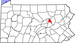
 Map of Montour County, Pennsylvania Highlighting West Hemlock Township | |
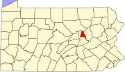
 Map of Montour County, Pennsylvania | |
| Country | United States |
| State | Pennsylvania |
| County | Montour |
| Incorporated | 1853 |
| Area [1] | |
| • Total | 7.71 sq mi (19.97 km2) |
| • Land | 7.70 sq mi (19.94 km2) |
| • Water | 0.01 sq mi (0.03 km2) |
| Population (2010) | |
| • Total | 503 |
| • Estimate (2016)[2] | 503 |
| • Density | 65.33/sq mi (25.22/km2) |
| FIPS code | 42-093-83144 |
West Hemlock Township is a township in Montour County, Pennsylvania, United States.
Geography
According to the United States Census Bureau, the township has a total area of 7.7 square miles (20.0 km2), all of it land.
Demographics
| Historical population | |||
|---|---|---|---|
| Census | Pop. | %± | |
| 2000 | 489 | — | |
| 2010 | 503 | 2.9% | |
| Est. 2016 | 503 | [2] | 0.0% |
| U.S. Decennial Census[3] | |||
As of the census[4] of 2000, there were 489 people, 168 households, and 150 families residing in the township. The population density was 63.2 people per square mile (24.4/km2). There were 182 housing units at an average density of 23.5/sq mi (9.1/km2). The racial makeup of the township was 99.18% White, 0.61% African American and 0.20% Asian.
There were 168 households, out of which 38.1% had children under the age of 18 living with them, 76.8% were married couples living together, 7.7% had a female householder with no husband present, and 10.7% were non-families. 10.7% of all households were made up of individuals, and 3.0% had someone living alone who was 65 years of age or older. The average household size was 2.91 and the average family size was 3.05.
In the township the population was spread out, with 27.2% under the age of 18, 7.2% from 18 to 24, 31.7% from 25 to 44, 25.2% from 45 to 64, and 8.8% who were 65 years of age or older. The median age was 39 years. For every 100 females, there were 109.9 males. For every 100 females age 18 and over, there were 113.2 males.
The median income for a household in the township was $45,625, and the median income for a family was $50,000. Males had a median income of $32,500 versus $24,375 for females. The per capita income for the township was $18,428. About 7.3% of families and 7.9% of the population were below the poverty line, including 9.5% of those under age 18 and 10.6% of those age 65 or over.
References
^ "2016 U.S. Gazetteer Files". United States Census Bureau. Retrieved Aug 14, 2017..mw-parser-output cite.citation{font-style:inherit}.mw-parser-output .citation q{quotes:"""""""'""'"}.mw-parser-output .citation .cs1-lock-free a{background:url("//upload.wikimedia.org/wikipedia/commons/thumb/6/65/Lock-green.svg/9px-Lock-green.svg.png")no-repeat;background-position:right .1em center}.mw-parser-output .citation .cs1-lock-limited a,.mw-parser-output .citation .cs1-lock-registration a{background:url("//upload.wikimedia.org/wikipedia/commons/thumb/d/d6/Lock-gray-alt-2.svg/9px-Lock-gray-alt-2.svg.png")no-repeat;background-position:right .1em center}.mw-parser-output .citation .cs1-lock-subscription a{background:url("//upload.wikimedia.org/wikipedia/commons/thumb/a/aa/Lock-red-alt-2.svg/9px-Lock-red-alt-2.svg.png")no-repeat;background-position:right .1em center}.mw-parser-output .cs1-subscription,.mw-parser-output .cs1-registration{color:#555}.mw-parser-output .cs1-subscription span,.mw-parser-output .cs1-registration span{border-bottom:1px dotted;cursor:help}.mw-parser-output .cs1-ws-icon a{background:url("//upload.wikimedia.org/wikipedia/commons/thumb/4/4c/Wikisource-logo.svg/12px-Wikisource-logo.svg.png")no-repeat;background-position:right .1em center}.mw-parser-output code.cs1-code{color:inherit;background:inherit;border:inherit;padding:inherit}.mw-parser-output .cs1-hidden-error{display:none;font-size:100%}.mw-parser-output .cs1-visible-error{font-size:100%}.mw-parser-output .cs1-maint{display:none;color:#33aa33;margin-left:0.3em}.mw-parser-output .cs1-subscription,.mw-parser-output .cs1-registration,.mw-parser-output .cs1-format{font-size:95%}.mw-parser-output .cs1-kern-left,.mw-parser-output .cs1-kern-wl-left{padding-left:0.2em}.mw-parser-output .cs1-kern-right,.mw-parser-output .cs1-kern-wl-right{padding-right:0.2em}
^ ab "Population and Housing Unit Estimates". Retrieved June 9, 2017.
^ "Census of Population and Housing". Census.gov. Retrieved June 4, 2016.
^ "American FactFinder". United States Census Bureau. Retrieved 2008-01-31.
Municipalities and communities of Montour County, Pennsylvania, United States | ||
|---|---|---|
County seat: Danville | ||
| Boroughs |
|  |
| Townships |
| |
| Unincorporated communities |
| |
Coordinates: 41°01′00″N 76°34′29″W / 41.01667°N 76.57472°W / 41.01667; -76.57472


