Carrieton
Carrieton South Australia | |||||||||||||||
|---|---|---|---|---|---|---|---|---|---|---|---|---|---|---|---|
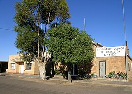 Carrieton Memorial hall and council office. | |||||||||||||||
 Carrieton | |||||||||||||||
| Coordinates | 32°25′34″S 138°31′44″E / 32.426072°S 138.529015°E / -32.426072; 138.529015Coordinates: 32°25′34″S 138°31′44″E / 32.426072°S 138.529015°E / -32.426072; 138.529015[1] | ||||||||||||||
| Population | 51 (2016 census)[2][a] | ||||||||||||||
| Established | 10 April 1879 (town) 16 December 1999 (locality)[4][5] | ||||||||||||||
| Postcode(s) | 5432[6] | ||||||||||||||
| Elevation | 440 m (1,444 ft)[citation needed] | ||||||||||||||
| Time zone | ACST (UTC+9:30) | ||||||||||||||
| • Summer (DST) | ACST (UTC+10:30) | ||||||||||||||
| Location | 327.8 km (204 mi) North of Adelaide | ||||||||||||||
| LGA(s) | District Council of Orroroo Carrieton[1] | ||||||||||||||
| Region | Yorke and Mid North[1] | ||||||||||||||
| County | Dalhousie[1] | ||||||||||||||
| State electorate(s) | Stuart[7] | ||||||||||||||
| Federal Division(s) | Grey[8] | ||||||||||||||
| |||||||||||||||
| |||||||||||||||
| Footnotes | Adjoining localities[1] | ||||||||||||||
Carrieton is a small town situated in the Flinders Ranges of South Australia. It is located between the towns of Orroroo to the south and Cradock to the north.
Originally opened in 1877 as Yanyarrie Whim, (Yanyarrie is in the local indigenous dialect "eagle feathers") with the construction of a post office, the settlement was renamed in 1888 as Carrieton, after the daughter of Governor Jervois, Lucy Caroline.[10]
Contents
1 Railways
2 Colonial History
3 Recent history
4 Carrieton Rodeo
5 References
Railways
The town was on the Peterborough–Quorn railway line which opened in December 1881, served by a Class 1 station. A large goods shed and fettler's cottage were also constructed.
Passenger services were discontinued during 1969, when the South Australian Railways withdrew the railcar service.[citation needed]
Declining rail traffic saw the gradual withdrawal of services on the railway, with the last station master being withdrawn on 1 July 1971. The railway was closed in 1981, and removed during 1986.[11]
Colonial History
Carrieton acquired a school (1882), a police station (1884), St Raphael's Roman Catholic Church (the large presbytery was built in 1889), a small Methodist Church (1882), an Anglican Church (1888) and the railway station, built in 1885 at a cost of £1,500.[12]
Recent history
The road was renamed the RM Williams Way in recognition of the area where R. M. Williams had many associations. Carrieton is often referred to as 'Gum Greek' country. The town is serviced through a community general store, hotel, post office, and accommodation, and it is a part of the District Council of Orroroo Carrieton. Recently, after large downpours in January,[when?] many of the creeks surrounding Carrieton were demolished. The bridge over Yanyarrie Creek 10 km north of Carrieton was especially damaged as huge slates of bitumen disappeared down the creek. Yanyarrie creek has since been repaired with a detour, after the first detour was ruined again by another flash flood a few weeks after the first one.[citation needed]
Carrieton Rodeo
Carrieton is home to the Carrieton Rodeo, an Australian Professional Rodeos Association event, held every year on Proclamation Day. It held its 60th anniversary meet on 28 December 2012.[13]
References
- Notes
^ For the 2016 census, the ‘State Suburb of Carrieton’ consisted of the locality of Carrieton and the part of the locality of Moockra which is located in the District Council of Orroroo Carrieton.[3]
- Citations
^ abcde "Search results for 'Carrieton, LOCB' with the following datasets being selected - 'Suburbs and Localities', 'Postcode', 'Counties', 'Hundreds', 'Local Government Areas', 'SA Government Regions', 'Land Development Plan Zone Categories' and 'Gazetteer'". Location SA Map Viewer. Government of South Australia. Retrieved 14 February 2018..mw-parser-output cite.citation{font-style:inherit}.mw-parser-output .citation q{quotes:"""""""'""'"}.mw-parser-output .citation .cs1-lock-free a{background:url("//upload.wikimedia.org/wikipedia/commons/thumb/6/65/Lock-green.svg/9px-Lock-green.svg.png")no-repeat;background-position:right .1em center}.mw-parser-output .citation .cs1-lock-limited a,.mw-parser-output .citation .cs1-lock-registration a{background:url("//upload.wikimedia.org/wikipedia/commons/thumb/d/d6/Lock-gray-alt-2.svg/9px-Lock-gray-alt-2.svg.png")no-repeat;background-position:right .1em center}.mw-parser-output .citation .cs1-lock-subscription a{background:url("//upload.wikimedia.org/wikipedia/commons/thumb/a/aa/Lock-red-alt-2.svg/9px-Lock-red-alt-2.svg.png")no-repeat;background-position:right .1em center}.mw-parser-output .cs1-subscription,.mw-parser-output .cs1-registration{color:#555}.mw-parser-output .cs1-subscription span,.mw-parser-output .cs1-registration span{border-bottom:1px dotted;cursor:help}.mw-parser-output .cs1-ws-icon a{background:url("//upload.wikimedia.org/wikipedia/commons/thumb/4/4c/Wikisource-logo.svg/12px-Wikisource-logo.svg.png")no-repeat;background-position:right .1em center}.mw-parser-output code.cs1-code{color:inherit;background:inherit;border:inherit;padding:inherit}.mw-parser-output .cs1-hidden-error{display:none;font-size:100%}.mw-parser-output .cs1-visible-error{font-size:100%}.mw-parser-output .cs1-maint{display:none;color:#33aa33;margin-left:0.3em}.mw-parser-output .cs1-subscription,.mw-parser-output .cs1-registration,.mw-parser-output .cs1-format{font-size:95%}.mw-parser-output .cs1-kern-left,.mw-parser-output .cs1-kern-wl-left{padding-left:0.2em}.mw-parser-output .cs1-kern-right,.mw-parser-output .cs1-kern-wl-right{padding-right:0.2em}
^ Australian Bureau of Statistics (27 June 2017). "State Suburb of Carrieton". 2016 Census QuickStats. Retrieved 14 February 2018.

^ "Search results for 'Moockra, LOCB' with the following datasets being selected - 'Suburbs and Localities', 'Local Government Areas' and 'Gazetteer'". Location SA Map Viewer. Government of South Australia. Retrieved 14 February 2018.
^ "Untitled proclamation under the Crown Lands Consolidation Act re the Town of Carrieton" (PDF). The South Australian Government Gazette. South Australian Government. 10 April 1879. p. 1071. Retrieved 14 February 2018.
^ "GEOGRAPHICAL NAMES ACT 1991, Notice to Assign Boundaries and Names to Places" (PDF), The South Australian Government Gazette: 3429, 16 December 1999, retrieved 14 February 2018
^ Carrieton Postcode Australia Post
^ "Electoral district of Stuart". Electoral Commission SA. Retrieved 12 February 2018.
^ "Federal electoral division of Grey" (PDF). Australian Electoral Commission. Retrieved 12 February 2018.
^ abc "Climate statistics for HAWKER (nearest station)". Bureau of Meteorology. Retrieved 14 February 2018.
^ Manning, G; 1990 Manning's Place Names of South Australia
ISBN 05437687505
^ Evans, J 2009; Proceed to Quorn Railmac Publications
ISBN 978-1-86477-066-X
^ Manning, Geoff. "Y" (PDF). South Australian Place names. State Library of South Australia. p. 6. Retrieved 11 December 2017.
^ "Archived copy". Archived from the original on 28 July 2013. Retrieved 2013-07-08.CS1 maint: Archived copy as title (link)
[not in citation given]