For the fictional planet, see List of Foundation universe planets § Ifni.
‹ The template Infobox former subdivision is being considered for merging. ›
Ifni
Province of Spain
←
1958–1969
→
Coat of arms
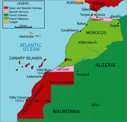
Map showing Ifni as the very small central red area (click to enlarge).
Capital
Sidi Ifni
Governor-General
•
1958–1961 (first)
Mariano Gómez Zamalloa y Quirce
•
1969 (last)
José Rodríguez
History
•
Established
12 January 1958
•
Returned to Morocco
4 January 1969
Area
•
1969
1,502 km2(580 sq mi)
Population
•
1964
51,517
Map sheet showing boundary of the former Ifni Province.
Ifni was a Spanish province on the Atlantic coast of Morocco, south of Agadir and across from the Canary Islands.
It had a total area of 1,502 km² (580 sq mi), and a population of 51,517 in 1964. The main industry was fishing.
Contents
1History
2Postage stamps
3See also
4References
5External links
History
Spain's presence in the area can be traced to a settlement called Santa Cruz de la Mar Pequeña, founded in 1476. After attacks by the Berbers, the Spanish decided to focus on colonising other areas of North Africa and abandoned the region.
In the mid-19th century, when the European powers looked again to Africa for resources, Spain suddenly mooted an interest in its lost late medieval fortress in order to stake a claim to the southern part of Morocco. This served as a pretext for a short war with Morocco in 1859.
The territory and its main town of Sidi Ifni were ceded to Spain by the Sultanate of Morocco on 26 April 1860, but there was little interest in this colonial acquisition until 1934, when the Governor-General of Spanish Sahara took up residence.
Until 1952, Ifni region had the status of a protectorate. In this year, the region became part of Spanish West Africa (entity that grouped the colonies of Spanish Sahara and Cape Juby).
After the Ifni War (1957), most of the territory became occupied de facto by Morocco.
In 1958, the colony was made into a Spanish province in order to forestall United Nations criticism of continued colonisation.
Spain formally returned the territory to Morocco on 30 June 1969.[1]
Postage stamps
Spain began issuing postage stamps for Ifni in 1941, initially overprinting Spanish stamps with "TERRITORIO DE IFNI", then issuing new designs in 1943. Issues followed at the rate of about ten per year with the last on 23 November 1968. Most are commonly available and are more often seen unused than used.
See also
List of colonial governors of Ifni
Ifni War
Spanish West Africa
References
^United Nations Yearbook 1969, pp. 661-64.
External links
(in Spanish) Ifni Friend's Association (Asociación de Amigos de Ifni)
(in Spanish) Ifni stamp gallery
(in Spanish) The Corner of Sidi Ifni (El Rincón de Sidi Ifni)
(in Spanish) Ifni today (Links for traveling to Ifni)
(in Spanish) Jomabase photo album on Picasa
(in German) Maps of Ifni
v
t
e
Spanish Empire
Timeline–immersed
Catholic Monarchs
Treaty of Tordesillas
Italian Wars
Habsburgs
Golden Age
War of the League of Cognac
Encomiendas
New Laws in favour of the indigenous
Expulsion of the Moriscos
Ottoman–Habsburg wars
French Wars of Religion
Bruneian-Spanish conflict
Anglo-Spanish War (1585–1604)
Piracy in the Caribbean
Eighty Years' War
Spanish–Moro conflict
Thirty Years' War
Franco-Spanish War (1635–59)
Portuguese Restoration War
War of the Spanish Succession
Queen Anne's War
Bourbons
Bourbon Reforms
War of Jenkins' Ear
Treaty of Madrid (1750)
Seven Years' War
Nootka Convention
Napoleonic invasion
Third Treaty of San Ildefonso
Independence of Spanish continental Americas
Adams–Onís Treaty
Liberal constitution
Carlist Wars
Spanish–American War
German–Spanish Treaty (1899)
Spanish Civil War
Independence of Morocco
Independence of Equatorial Guinea
Western Sahara conflict
Territories
Kingdoms of Naples, Sicily and Sardinia
Milan
Union with Holy Roman Empire
Netherlands, Belgium, Luxembourg, northernmost France
American television organization Academy of Television Arts & Sciences Founded 1946 ; 73 years ago ( 1946 ) Location North Hollywood, California, United States Area served Television industry Product Emmy Awards Key people Frank Scherma ( Chairman and CEO ) Website televisionacademy.com [redirects to emmys.com , official website of the Emmys and the Television Academy The Academy of Television Arts & Sciences ( ATAS ), also colloquially known as the Television Academy , is a professional honorary organization dedicated to the advancement of the television industry in the United States. Founded in 1946, the organization presents the Primetime Emmy Awards, an annual ceremony honoring achievement in U.S. primetime television. Contents 1 History 2 Emmy Award 3 Publications and programs 4 Current governance 4.1 Board of Governors 5 Television Academy honors 5.1 1st Annual (2008) 5.2 2nd Annual (2009)...
For other uses, see Équipe (disambiguation). L'Équipe The front page of L'Équipe on 4 July 2011 Type Daily newspaper Format Tabloid Owner(s) Éditions Philippe Amaury Editor François Morinière Editor-in-chief Fabrice Jouhaud Founded 1946 Language French Headquarters Boulogne-Billancourt ISSN 0153-1069 Website www.lequipe.fr L'Équipe ( pronounced [lekip] , French for "the team") is a French nationwide daily newspaper devoted to sport, owned by Éditions Philippe Amaury. The paper is noted for coverage of association football , rugby, motorsport and cycling. Its predecessor was L'Auto , a general sports paper whose name reflected not any narrow interest but the excitement of the time in car racing. L'Auto originated the Tour de France cycling stage race in 1903 as a circulation booster. The race leader's yellow jersey (French: maillot jaune ) was instituted in 1919, probably to reflect the dist...
This article is a rough translation from French . It may have been generated by a computer or by a translator without dual proficiency. Please help to enhance the translation. The original article is under "français" in the "languages" sidebar. See this article's entry on Pages needing translation into English for discussion. 1995 France bombings Part of Algerian Civil War (spillover) Plaque commemorating the victims of the Saint-Michel station bombing on 25 July 1995 Location Paris and Lyon, France Date 25 July 1995 ( 1995-07-25 ) – 17 October 1995 ( 1995-10-17 ) Weapons Improvised explosive devices, school bombing Deaths 8 Non-fatal injuries 157 Perpetrator Armed Islamic Group Motive To induce the French government to withdraw support from the Algerian government during the Algerian Civil War The 1995 bombings in France were carried out by the Armed Islamic Group (GIA), who were broadening the Alger...
 Coat of arms