Morris, Minnesota
Morris | |
|---|---|
City | |
| City of Morris | |
| Nickname(s): Motown | |
| Motto(s): "It starts here.", "There's More in Morris!" | |
 Location of Morris within Stevens County and state of Minnesota | |
| Coordinates: 45°35′6″N 95°54′36″W / 45.58500°N 95.91000°W / 45.58500; -95.91000 | |
| Country | United States |
| State | Minnesota |
| County | Stevens |
| Founded by | Charles F. Morris |
| Government | |
| • Type | Weak mayor–council |
| • Mayor of Morris | Sheldon Giese |
| Area [1] | |
| • Total | 4.87 sq mi (12.62 km2) |
| • Land | 4.67 sq mi (12.10 km2) |
| • Water | 0.20 sq mi (0.52 km2) |
| Elevation | 1,132 ft (345 m) |
| Population (2010) | |
| • Total | 5,286 |
| • Estimate (2017)[2] | 5,297 |
| • Density | 1,134.02/sq mi (437.80/km2) |
| Time zone | UTC-6 (Central (CST)) |
| • Summer (DST) | UTC-5 (CDT) |
| ZIP code | 56267 |
| Area code(s) | 320 |
| FIPS code | 27-44242[3] |
GNIS feature ID | 0648116[4] |
| Website | www.ci.morris.mn.us |
Morris is a city in Stevens County, Minnesota, United States. The population was 5,286 at the 2010 census.[5] It is the county seat.[6]
The city is surrounded by some of the richest agricultural lands in the country, and agribusiness is important to the local economy. Headquartered in Morris, Riverview LLP is the largest dairy milking operation in Minnesota and ranked as one of the largest in the United States.[7] Other large economic contributors include manufacturing, education, and healthcare industries.
The town is home to the University of Minnesota Morris (UMM), part of the University of Minnesota system. It was established as a public college in 1960, on the grounds of a former industrial school for Native Americans. Today, the campus has a population of approximately 1,900 and is ranked as a "Top 10 Public Liberal Arts College" by U.S. News and World Report and one of "America's Top Colleges" by Forbes.[8]
Contents
1 History
2 Geography
2.1 Climate
3 Demographics
3.1 2010 census
3.2 2000 census
4 Economy
5 Higher education
6 Prairie Pioneer Days
7 Area media
8 Notable people
9 References
10 External links
History
Morris was platted in 1869 and named for Charles A. Morris, a railroad official.[9] A post office has been in operation at Morris since 1871.[10] Morris was incorporated as a city in 1902.[9]
The federal government and state in the 19th century had programs to try to assimilate Native Americans to the majority culture. The Sisters of Mercy Roman Catholic order, led by Sister Mary Joseph Lynch, established a boarding school for Indians in Morris, operating it from 1887 until 1896 under contract to the federal government. Initially most students came from Turtle Mountain Band of Chippewa Indians, which had many Catholic converts. The Morris Industrial School for Indians was to prepare students for jobs in the industrializing culture.[11]
The federal government then appointed staff to manage the school into the early 20th century, before transferring it to the state. After the state took over the school in the early 20th century for general education, it taught agricultural topics. Agriculture has continued to be a major part of the economy. In 1909 the University of Minnesota established the West Central School of Agriculture (WCSA), and Morris closed.[11]
When the state announced a phase-out plan for Morris and similar agricultural schools, a grassroots citizens movement convinced the state to establish a public college on the Morris campus. In the fall of 1960, the University of Minnesota, Morris opened its doors to students seeking a liberal arts education. It has been ranked as a "Top 10 Public Liberal Arts College" by U.S. News and World Report and one of "America's Top Colleges" by Forbes.[12]
The city contains five properties listed on the National Register of Historic Places: the 1881 Lewis H. Stanton House, the 1899 Morris Industrial School for Indians Dormitory, the 1905 Morris Carnegie Library, and the early-20th-century West Central School of Agriculture and Experiment Station Historic District. The Morris High School, begun in 1914, is also listed[13] even though it was demolished in 2013.[14]
The 1975 Morris earthquake occurred on July 9, and was the state's largest 20th-century earthquake, rated at 4.6 Mn.[15][16][17] Eighteen years later, on June 4, 1993, another quake slightly shook the community. This one measured 4.1 in magnitude and ranks as the third-largest earthquake in Minnesota of the 20th century.[18]
Geography
According to the United States Census Bureau, the city has a total area of 5.02 square miles (13.00 km2); 4.80 square miles (12.43 km2) is land and 0.22 square miles (0.57 km2) is water.[19] Lake Crystal is in the southwestern part of the town; the Pomme de Terre River flows through the town's eastern extremity.[20]U.S. Highway 59 and Minnesota State Highways 9 and 28 are three of the main routes in the town.
Climate
| Climate data for Morris, Minnesota (1981–2010 | |||||||||||||
|---|---|---|---|---|---|---|---|---|---|---|---|---|---|
| Month | Jan | Feb | Mar | Apr | May | Jun | Jul | Aug | Sep | Oct | Nov | Dec | Year |
| Average high °F (°C) | 19.7 (−6.8) | 24.5 (−4.2) | 36.7 (2.6) | 54.8 (12.7) | 68.3 (20.2) | 77.0 (25.0) | 81.2 (27.3) | 79.6 (26.4) | 71.0 (21.7) | 56.9 (13.8) | 38.6 (3.7) | 23.7 (−4.6) | 52.7 (11.5) |
| Average low °F (°C) | 0.5 (−17.5) | 5.7 (−14.6) | 19.3 (−7.1) | 33.2 (0.7) | 45.7 (7.6) | 55.8 (13.2) | 59.7 (15.4) | 56.9 (13.8) | 47.2 (8.4) | 34.3 (1.3) | 20.9 (−6.2) | 6.5 (−14.2) | 32.1 (0.1) |
| Average precipitation inches (mm) | 0.74 (19) | 0.71 (18) | 1.42 (36) | 2.31 (59) | 2.83 (72) | 4.01 (102) | 3.87 (98) | 3.33 (85) | 2.90 (74) | 2.55 (65) | 1.08 (27) | 0.71 (18) | 26.46 (673) |
| Source: NOAA[21] | |||||||||||||
Demographics
| Historical population | |||
|---|---|---|---|
| Census | Pop. | %± | |
| 1880 | 748 | — | |
| 1890 | 1,266 | 69.3% | |
| 1900 | 1,934 | 52.8% | |
| 1910 | 1,685 | −12.9% | |
| 1920 | 2,320 | 37.7% | |
| 1930 | 2,474 | 6.6% | |
| 1940 | 3,214 | 29.9% | |
| 1950 | 3,811 | 18.6% | |
| 1960 | 4,199 | 10.2% | |
| 1970 | 5,366 | 27.8% | |
| 1980 | 5,367 | 0.0% | |
| 1990 | 5,613 | 4.6% | |
| 2000 | 5,068 | −9.7% | |
| 2010 | 5,286 | 4.3% | |
| Est. 2017 | 5,297 | [2] | 0.2% |
| U.S. Decennial Census | |||
2010 census
As of the census[22] of 2010, there were 5,286 people, 1,986 households, and 1,021 families residing in the city. The population density was 1,101.3 inhabitants per square mile (425.2/km2). There were 2,199 housing units at an average density of 458.1 per square mile (176.9/km2). The racial makeup of the city was 90.9% White, 1.3% African American, 1.5% Native American, 2.5% Asian, 0.1% Pacific Islander, 1.1% from other races, and 2.6% from two or more races. Hispanic or Latino of any race were 3.2% of the population.
There were 1,986 households of which 23.6% had children under the age of 18 living with them, 41.7% were married couples living together, 7.3% had a female householder with no husband present, 2.4% had a male householder with no wife present, and 48.6% were non-families. 35.9% of all households were made up of individuals and 16.4% had someone living alone who was 65 years of age or older. The average household size was 2.23 and the average family size was 2.87.
The median age in the city was 26.5 years. 17.7% of residents were under the age of 18; 30.8% were between the ages of 18 and 24; 17.4% were from 25 to 44; 18.1% were from 45 to 64; and 16.1% were 65 years of age or older. The gender makeup of the city was 46.6% male and 53.4% female.
2000 census
As of the census[3] of 2000, there were 5,068 people, 1,929 households, and 985 families residing in the town. The population density was 1,183.2 people per square mile (457.2/km²). There were 2,067 housing units at an average density of 482.6 per square mile (186.5/km²). The racial makeup of the town was 93.63% White, 1.76% African American, 1.22% Native American, 1.54% Asian, 0.02% Pacific Islander, 0.63% from other races, and 1.20% from two or more races. Hispanic or Latino of any race were 1.48% of the population.
There were 1,929 households out of which 23.4% had children under the age of 18 living with them, 42.0% were married couples living together, 6.8% had a female householder with no husband present, and 48.9% were non-families. 36.9% of all households were made up of individuals and 17.7% had someone living alone who was 65 years of age or older. The average household size was 2.20 and the average family size was 2.84.
In the town the population was spread out with 16.7% under the age of 18, 34.2% from 18 to 24, 19.0% from 25 to 44, 13.9% from 45 to 64, and 16.2% who were 65 years of age or older. The median age was 24 years. For every 100 females, there were 85.9 males. For every 100 females age 18 and over, there were 82.6 males.
The median income for a household in the town was $31,786, and the median income for a family was $46,556. Males had a median income of $34,323 versus $22,338 for females. The per capita income for the town was $16,607. About 8.4% of families and 22.4% of the population were below the poverty line, including 9.6% of those under age 18 and 14.9% of those age 65 or over.
Economy
Agribusiness contributes to the economy, as the region is still mostly rural. The state university is a major employer at its three facilities.
Manufacturer Superior Industries employs about 800 people at its two plants in town. A majority of Superior's workforce is skilled in engineering or fabrication. The company manufactures steel conveyors and storage tanks for industries handling dry bulk, fuels and gases. Inc. magazine ranks Superior Industries as one of the fastest-growing private companies in the United States.[23]
Higher education
The University of Minnesota Morris (UMM) is one of five campuses in the University of Minnesota system. It was established as a public college in 1960, on the grounds of the Morris Industrial School for Indians, which had also operated as an agricultural school. UMM has an enrollment of about 1,900 students and 145 teaching faculty. Some 61 students made up the first graduating class in 1961. Since then, Morris has conferred more than 10,000 degrees.
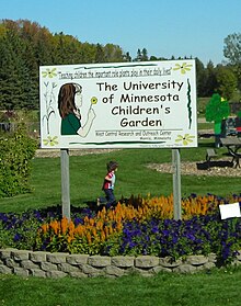
The Children's Garden at the West Central Research and Outreach Center, Morris.
Morris is home to the West Central Research and Outreach Center, a division of the greater University of Minnesota's College of Food, Agricultural and Natural Resource Sciences. WCROC's faculty and staff study agronomy, soil science, livestock, horticulture, renewable energy and swine production.
WCROC is home to the University of Minnesota's Horticulture Gardens. During the last decade, the privately funded research gardens have gained increasing popularity. Their design has increased in aesthetic appeal while maintaining a research base. Each summer, the gardens are host to thousands of visitors.
Prairie Pioneer Days
Prairie Pioneer Days is a family festival hosted by the Morris Area Chamber of Commerce every July, which celebrates European-American settlement in the area.[24] It includes many activities around town, including a parade, fireworks, and food and craft vendors. Since the late 20th century, festival organizers have also worked to include Native American participants and acknowledge contributions by their cultures.
Area media
Four radio stations cover Morris; KMRS AM 1230, KKOK FM 95.7, and KRVY FM 97.3, all owned by Iowa City Broadcasting Company, Inc., while KUMM FM 89.7 is operated by the University of Minnesota Morris.
The Stevens County Times, a Forum Communications newspaper, publishes on Saturdays.
Notable people
Dick Grace (1898–1965), Hollywood stunt pilot
Jim Hall, Free software advocate, best known for FreeDOS
Mike Morley, former professional golfer
PZ Myers, biologist and blogger
Trina Radke, Olympic swimmer
Aaron Schock, former United States Congressman elected to the United States House of Representatives from Illinois (2009–2015)
Royal A. Stone, Minnesota Supreme Court justice
Brett Winkelman, former basketball player for the North Dakota State Bison
Children 18:3, Christian punk rock band
References
^ "2017 U.S. Gazetteer Files". United States Census Bureau. Retrieved Jan 3, 2019..mw-parser-output cite.citation{font-style:inherit}.mw-parser-output .citation q{quotes:"""""""'""'"}.mw-parser-output .citation .cs1-lock-free a{background:url("//upload.wikimedia.org/wikipedia/commons/thumb/6/65/Lock-green.svg/9px-Lock-green.svg.png")no-repeat;background-position:right .1em center}.mw-parser-output .citation .cs1-lock-limited a,.mw-parser-output .citation .cs1-lock-registration a{background:url("//upload.wikimedia.org/wikipedia/commons/thumb/d/d6/Lock-gray-alt-2.svg/9px-Lock-gray-alt-2.svg.png")no-repeat;background-position:right .1em center}.mw-parser-output .citation .cs1-lock-subscription a{background:url("//upload.wikimedia.org/wikipedia/commons/thumb/a/aa/Lock-red-alt-2.svg/9px-Lock-red-alt-2.svg.png")no-repeat;background-position:right .1em center}.mw-parser-output .cs1-subscription,.mw-parser-output .cs1-registration{color:#555}.mw-parser-output .cs1-subscription span,.mw-parser-output .cs1-registration span{border-bottom:1px dotted;cursor:help}.mw-parser-output .cs1-ws-icon a{background:url("//upload.wikimedia.org/wikipedia/commons/thumb/4/4c/Wikisource-logo.svg/12px-Wikisource-logo.svg.png")no-repeat;background-position:right .1em center}.mw-parser-output code.cs1-code{color:inherit;background:inherit;border:inherit;padding:inherit}.mw-parser-output .cs1-hidden-error{display:none;font-size:100%}.mw-parser-output .cs1-visible-error{font-size:100%}.mw-parser-output .cs1-maint{display:none;color:#33aa33;margin-left:0.3em}.mw-parser-output .cs1-subscription,.mw-parser-output .cs1-registration,.mw-parser-output .cs1-format{font-size:95%}.mw-parser-output .cs1-kern-left,.mw-parser-output .cs1-kern-wl-left{padding-left:0.2em}.mw-parser-output .cs1-kern-right,.mw-parser-output .cs1-kern-wl-right{padding-right:0.2em}
^ ab "Population and Housing Unit Estimates". Retrieved March 24, 2018.
^ ab "American FactFinder". United States Census Bureau. Retrieved 2008-01-31.
^ "US Board on Geographic Names". United States Geological Survey. 2007-10-25. Retrieved 2008-01-31.
^ "2010 Census Redistricting Data (Public Law 94-171) Summary File". American FactFinder. U.S. Census Bureau, 2010 Census. Retrieved 23 April 2011.
^ "Find a County". National Association of Counties. Retrieved 2011-06-07.
^ [1][permanent dead link], "The Riverview Way"
^ [2], "National Rankings"
^ ab Upham, Warren (1920). Minnesota Geographic Names: Their Origin and Historic Significance. Minnesota Historical Society. p. 537.
^ "Stevens County". Jim Forte Postal History. Retrieved 1 August 2015.
^ ab Ahern, Wilbert H. (1984). "Indian Education and Bureaucracy: The School at Morris, 1887-1909" (PDF). Minnesota History: 82–98.
^ [3], "National Rankings"
^ "Minnesota National Register Properties Database". Minnesota Historical Society. 2009. Retrieved 2018-03-11.
^ Vogel, Jennifer (2013-07-05). "Sometimes they can't be saved: Morris to tear down elementary school". Minnesota Public Radio. Missing or empty|url=(help);|access-date=requires|url=(help)
^ "Archived copy". Archived from the original on 2016-11-10. Retrieved 2017-09-05.CS1 maint: Archived copy as title (link)
^ "West Central Minnesota's Earthquakes" Archived 2007-07-01 at the Wayback Machine, University of Minnesota Morris
^ Earthquake Shock Felt In Area Archived 2009-02-07 at the Wayback Machine, Morris Tribune, July 10, 1975
^ "Archived copy". Archived from the original on 2011-04-03. Retrieved 2009-06-21.CS1 maint: Archived copy as title (link), University of Minnesota Morris
^ "US Gazetteer files 2010". United States Census Bureau. Archived from the original on 2012-01-24. Retrieved 2012-11-13.
^ Minnesota Atlas & Gazetteer. Yarmouth, Me.: DeLorme. 1994. p. 44. ISBN 0-89933-222-6.
^ "Morris WC Exp St monthly summarized data (1981–2010)". NOWData. Twin Cities: National Weather Service Forecast Office.
^ "American FactFinder". United States Census Bureau. Retrieved 2012-11-13.
^ [4]
^ "Prairie Pioneer Days". Morris Area Chamber of Commerce. Archived from the original on 28 October 2013. Retrieved 26 August 2013.
External links
 Media related to Morris, Minnesota at Wikimedia Commons
- Morris, Minnesota Police Department
Municipalities and communities of Stevens County, Minnesota, United States | ||
|---|---|---|
County seat: Morris | ||
| Cities |
|  |
| Townships |
| |
Coordinates: 45°35′10″N 95°54′50″W / 45.58611°N 95.91389°W / 45.58611; -95.91389


