Dunster, British Columbia
Dunster, British Columbia | |
|---|---|
Community | |
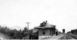 GTP Station at Dunster (1920s) | |
 Dunster, British Columbia Location of Dunster in British Columbia | |
| Coordinates: 53°07′27″N 119°50′16″W / 53.12417°N 119.83778°W / 53.12417; -119.83778 | |
| Country | Canada |
| Province | British Columbia |
| Regional District | Fraser-Fort George |
| Postal code | V0J |
| Area code(s) | 250, 778 |
Dunster is a small farming community in the Robson Valley region of British Columbia, Canada.[1] It is located 31 km east of McBride and 37 km west of Tête Jaune Cache, and 10 km north of Croydon. Dunster is home to one of the few remaining, original and least altered Grand Trunk Pacific Railway stations.
Contents
1 History
2 Climate
3 See also
4 External links
5 References
History
Dunster was named after Dunster, England. Railroad manager, H.P. Hinton chose the name from a list provided to him by Josiah Wedgwood.[2] The station was constructed in 1913. The Dunster Post Office was opened 1 December 1915 with George Hall as the first postmaster. In 1921 Mrs A. McDonald became postmaster.
Climate
| Climate data for Dunster, British Columbia | |||||||||||||
|---|---|---|---|---|---|---|---|---|---|---|---|---|---|
| Month | Jan | Feb | Mar | Apr | May | Jun | Jul | Aug | Sep | Oct | Nov | Dec | Year |
| Record high °C (°F) | 8 (46) | 11.5 (52.7) | 19 (66) | 27.2 (81.0) | 35 (95) | 33.5 (92.3) | 34.5 (94.1) | 35 (95) | 33 (91) | 25 (77) | 16.1 (61.0) | 11 (52) | 35 (95) |
| Average high °C (°F) | −3.9 (25.0) | −0.1 (31.8) | 6.1 (43.0) | 12.5 (54.5) | 17.4 (63.3) | 20.5 (68.9) | 23.2 (73.8) | 22.4 (72.3) | 17 (63) | 10 (50) | 1 (34) | −4 (25) | 10.2 (50.4) |
| Daily mean °C (°F) | −7.7 (18.1) | −4.6 (23.7) | 0.5 (32.9) | 5.7 (42.3) | 10.1 (50.2) | 13.2 (55.8) | 15.4 (59.7) | 14.8 (58.6) | 10.5 (50.9) | 5.2 (41.4) | −2.3 (27.9) | −7.4 (18.7) | 4.5 (40.1) |
| Average low °C (°F) | −11.6 (11.1) | −9 (16) | −5.1 (22.8) | −1.1 (30.0) | 2.8 (37.0) | 6 (43) | 7.5 (45.5) | 7.1 (44.8) | 4 (39) | 0.4 (32.7) | −5.6 (21.9) | −10.8 (12.6) | −1.3 (29.7) |
| Record low °C (°F) | −42 (−44) | −45.5 (−49.9) | −36 (−33) | −16.7 (1.9) | −5 (23) | −3 (27) | −0.5 (31.1) | −5 (23) | −7.5 (18.5) | −27 (−17) | −39 (−38) | −45 (−49) | −45.5 (−49.9) |
| Average precipitation mm (inches) | 55.9 (2.20) | 41.3 (1.63) | 39.1 (1.54) | 31.9 (1.26) | 43.4 (1.71) | 60.6 (2.39) | 59.6 (2.35) | 55.5 (2.19) | 50.5 (1.99) | 64.9 (2.56) | 61.1 (2.41) | 67.1 (2.64) | 630.7 (24.83) |
| Source: 1971-2000 Environment Canada [3] | |||||||||||||
See also
- Dunster Fine Arts School
- Dunster CN railway station
External links
- Vanishing British Columbia: Grand Trunk Pacific Railway Stations
- Dunster Community webpage
- Map from British Columbia Travel and Discovery
- Robson Valley Music Festival
BCGNIS Geographical Name QueryCoordinates: 53°07′01″N 119°49′59″W / 53.117°N 119.833°W / 53.117; -119.833
References
^ "BC Geographical Names". apps.gov.bc.ca. Retrieved 2017-02-16..mw-parser-output cite.citation{font-style:inherit}.mw-parser-output .citation q{quotes:"""""""'""'"}.mw-parser-output .citation .cs1-lock-free a{background:url("//upload.wikimedia.org/wikipedia/commons/thumb/6/65/Lock-green.svg/9px-Lock-green.svg.png")no-repeat;background-position:right .1em center}.mw-parser-output .citation .cs1-lock-limited a,.mw-parser-output .citation .cs1-lock-registration a{background:url("//upload.wikimedia.org/wikipedia/commons/thumb/d/d6/Lock-gray-alt-2.svg/9px-Lock-gray-alt-2.svg.png")no-repeat;background-position:right .1em center}.mw-parser-output .citation .cs1-lock-subscription a{background:url("//upload.wikimedia.org/wikipedia/commons/thumb/a/aa/Lock-red-alt-2.svg/9px-Lock-red-alt-2.svg.png")no-repeat;background-position:right .1em center}.mw-parser-output .cs1-subscription,.mw-parser-output .cs1-registration{color:#555}.mw-parser-output .cs1-subscription span,.mw-parser-output .cs1-registration span{border-bottom:1px dotted;cursor:help}.mw-parser-output .cs1-ws-icon a{background:url("//upload.wikimedia.org/wikipedia/commons/thumb/4/4c/Wikisource-logo.svg/12px-Wikisource-logo.svg.png")no-repeat;background-position:right .1em center}.mw-parser-output code.cs1-code{color:inherit;background:inherit;border:inherit;padding:inherit}.mw-parser-output .cs1-hidden-error{display:none;font-size:100%}.mw-parser-output .cs1-visible-error{font-size:100%}.mw-parser-output .cs1-maint{display:none;color:#33aa33;margin-left:0.3em}.mw-parser-output .cs1-subscription,.mw-parser-output .cs1-registration,.mw-parser-output .cs1-format{font-size:95%}.mw-parser-output .cs1-kern-left,.mw-parser-output .cs1-kern-wl-left{padding-left:0.2em}.mw-parser-output .cs1-kern-right,.mw-parser-output .cs1-kern-wl-right{padding-right:0.2em}
^ Sedgwick, J. Kent (2008). Giscome Chronicle: The rise and demise of a sawmill community in central British Columbia. Prince George: CNC Press. p. 2.
^ Environment Canada—1971–2000. Retrieved 12 November 2012.
This article about a location in the Interior of British Columbia, Canada is a stub. You can help Wikipedia by expanding it. |


