Mountcharles
Mountcharles Tamhnach an tSalainn | |
|---|---|
Village | |
 | |
 Mountcharles Location in Ireland | |
| Coordinates: 54°39′N 8°12′W / 54.650°N 8.200°W / 54.650; -8.200Coordinates: 54°39′N 8°12′W / 54.650°N 8.200°W / 54.650; -8.200 | |
| Country | Ireland |
| Province | Ulster |
| County | County Donegal |
| Government | |
| • Dáil Éireann | Donegal |
| Population (2016)[1] | |
| • Total | 484 |
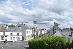
Mountcharles (Irish: Tamhnach an tSalainn)[2][3][4] is a townland (of 650 acres) and a village in County Donegal, Ireland. It lies 6 km from Donegal on the Killybegs road (N56). It is situated in the civil parish of Inver and the historic barony of Banagh.[5] The village's name is usually pronounced locally as 'Mount-char-liss'.
Contents
1 Name
2 History
2.1 Pre-Famine Mountcharles
2.2 Hall Demesne
3 Politics
4 Transport
5 Amenities
6 Sport
7 Notable people
8 See also
9 References
Name
In pre-Plantation times the area from the present N56 to the sea, including modern day Salthill, was known as Tamhnach an tSalainn ("the field of salt"). This refers to the fields along the coast which flooded with seawater with the flow of the tide, as the water receded, salt remnants remained in the fields.
The Irish name for the village refers to this salt mine in the area which local people worked in, and at a growing rate, as the salt extraction rate was increased by the plantation founder, Charles Conyngham.[6] The name was later anglicized as Tawnaghtallan and Tawnytallan.[2]
Whereupon English became the only language permitted for placenames in Ireland, the Cistercian Grange in the area was known as the Grange of Tawnytallon which led to the area being anglicised as Tawnaghtallan and Tawnytallan.[2]
The English name for the village owes its origin to the Scottish plantation 'undertaker', Charles Conyngham, who arrived in Donegal during the Plantation of Ulster and asserted a landlord control over the area, renaming the region Mount Charles after himself.[3] He is the ancestor of The 8th Marquess Conyngham (frequently, if inaccurately, known as 'Lord Henry Mountcharles') of Slane Castle, County Meath. By controlling the sale of salt from the region, Charles Conyngham then financed the building of the few surviving buildings in the village in the 17th century. The Conyngham estate and its large estate house (Hall Demesne), close to the village, are now unoccupied. The courtesy title of the heir apparent of The Marquess Conyngham is Earl of Mount Charles, being named after the village.
Alternatively, the origin of the modern name, Mountcharles, is from the 1660s.[citation needed] Albert Conyngham, son of Rev. Alexander Conyngham (Dean of Raphoe), was knighted by Charles II in 1666, and, in honour of the king,[citation needed][dubious ] the plantation founders, the Conyngham's enforced the name change to Mountcharles.
History
In 1611, at the start of the Plantation of Ulster, The Rev. Alexander Conyngham, first Church of Ireland Rector of Inver and Killymard, took ownership over the area, designating the area near the present Hall House as his own.[7]
The village of Mountcharles was controlled by the Conyngham family thereafter.[8] In 1676 Mountcharles was granted the sole right to hold markets and fairs: "Mountcharles, alias Tounytallon, a Friday market and four fairs on the 19th May, 11th September, 11th November and 17th March. Pursuant to patent signed and dated at Whitehall 9th December 1675 – granted to Sir Albert Conyngham, Kt. – July 27th 1676”.[9] The courtesy title of the heir apparent of The Marquess Conyngham is Earl of Mount Charles, is named after the village.
Arthur Young[who?] visited Mountcharles during his Tour of 1786.
Pre-Famine Mountcharles
The early houses were built with stone, which was quarried near St. Peter’s Lough and at the quarries behind the town. The early houses were thatched. According to both the 1841 Census and Lewis’ Topographical Dictionary of Ireland, Mountcharles was the only town in the parish pre-Famine times.[10]
Hall Demesne
The former country house of the Conyngham family, The Hall, is nearby the village. From the beginning of the 18th century the Conynghams no longer regarded Mountcharles as their principal seat, but Slane. It was sold by The 6th Marquess Conyngham immediately after World War II, in 1946, to pay for the installation of electricity in Slane Castle, Co. Meath.
Politics
Mountcharles gave its name to the Electoral Division of Mountcharles (Mountcharles DED) from 1850 to around 1956 but this Electoral Division was renamed to Tantallon in the late 1950s and statistically enumerated as such from the 1961 Census.[11] Mountcharles is part of the five-seat Donegal constituency.
Transport
Mountcharles railway station was on a branch line of the County Donegal Railways Joint Committee, a narrow gauge railway system. It was opened on 18 August 1893 and shut on 1 January 1960.[12]
Amenities
The village has one general shop on the Main Street. A fishmongers, a local butchers, a post office, a pharmacy and local tea rooms. The area also hosts a pilates and yoga centre as well as a massage therapist, a beauticians, several hairdressers and a barber shop. There are two bars on the main street.[citation needed]
Sport
The village has a Gaelic games pitch that belongs to the local club Saint Naul's (Irish: Naomh Naile) and a nearby a football club, Eany Celtic F.C. In 2013, the Mountcharles Rowing Club was established.
Notable people
Cahir Healy, politician
Seumas MacManus, author, dramatist and poet
Stephen Joseph McGroarty, Irish-born American soldier
See also
- List of urban areas in Ireland
References
^ "Census 2016 Sapmap Area: Settlements Mountcharles". Central Statistics Office (Ireland). Retrieved 2018-06-04..mw-parser-output cite.citation{font-style:inherit}.mw-parser-output .citation q{quotes:"""""""'""'"}.mw-parser-output .citation .cs1-lock-free a{background:url("//upload.wikimedia.org/wikipedia/commons/thumb/6/65/Lock-green.svg/9px-Lock-green.svg.png")no-repeat;background-position:right .1em center}.mw-parser-output .citation .cs1-lock-limited a,.mw-parser-output .citation .cs1-lock-registration a{background:url("//upload.wikimedia.org/wikipedia/commons/thumb/d/d6/Lock-gray-alt-2.svg/9px-Lock-gray-alt-2.svg.png")no-repeat;background-position:right .1em center}.mw-parser-output .citation .cs1-lock-subscription a{background:url("//upload.wikimedia.org/wikipedia/commons/thumb/a/aa/Lock-red-alt-2.svg/9px-Lock-red-alt-2.svg.png")no-repeat;background-position:right .1em center}.mw-parser-output .cs1-subscription,.mw-parser-output .cs1-registration{color:#555}.mw-parser-output .cs1-subscription span,.mw-parser-output .cs1-registration span{border-bottom:1px dotted;cursor:help}.mw-parser-output .cs1-ws-icon a{background:url("//upload.wikimedia.org/wikipedia/commons/thumb/4/4c/Wikisource-logo.svg/12px-Wikisource-logo.svg.png")no-repeat;background-position:right .1em center}.mw-parser-output code.cs1-code{color:inherit;background:inherit;border:inherit;padding:inherit}.mw-parser-output .cs1-hidden-error{display:none;font-size:100%}.mw-parser-output .cs1-visible-error{font-size:100%}.mw-parser-output .cs1-maint{display:none;color:#33aa33;margin-left:0.3em}.mw-parser-output .cs1-subscription,.mw-parser-output .cs1-registration,.mw-parser-output .cs1-format{font-size:95%}.mw-parser-output .cs1-kern-left,.mw-parser-output .cs1-kern-wl-left{padding-left:0.2em}.mw-parser-output .cs1-kern-right,.mw-parser-output .cs1-kern-wl-right{padding-right:0.2em}
^ abc Placenames Database of Ireland: Mountcharles/Tamhnach an tSalainn
^ ab "TV Mountcharles". We Love Donegal. Retrieved 2015-12-23.
^ ""Tamhnach" translation in Irish English Dictionary Foclóir".
^ "Mountcharles". IreAtlas Townlands Database. Retrieved 6 May 2015.
^ Searc.ie. "Donegal County.com & Dún-na-nGall.com - Mountcharles / Tamhnach an tSalainn". Dun-na-ngall.com. Archived from the original on 2016-03-03. Retrieved 2015-12-23.CS1 maint: BOT: original-url status unknown (link)
^ Meehan, Helen (2005). Inver Parish in History. Mountcharles: Helen Meehan. p. 446. ISBN 9780955175107.
^ Meehan, Helen (1999). "The Conyngham's of Slane and Mountcharles". Donegal Annual. 51.
^ Meehan, Helen (1999). "The Conyngham's of Slane and Mountcharles". Donegal Annual. 56.
^ Meehan, Helen (2005). Inver Parish in History. Mouncharles: Helen Meehan. p. 447. ISBN 9780955175107.
^ "Census of Population 1961" (PDF). pp. 144 of 164. Retrieved 23 January 2017.
^ "Mountcharles station" (PDF). Railscot - Irish Railways. Retrieved 18 November 2007.
Places in County Donegal | ||
|---|---|---|
County town: Lifford | ||
| Towns |
|  |
| Villages |
| |
| Townlands |
| |
| Islands |
| |
| Other regions |
| |
| ||


