Buckingham County, Virginia
Buckingham County, Virginia | ||
|---|---|---|
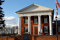 Buckingham County Courthouse | ||
| ||
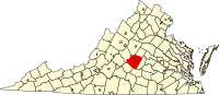 Location in the U.S. state of Virginia | ||
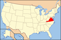 Virginia's location in the U.S. | ||
| Founded | 1761 | |
| Named for | Duke of Buckingham | |
| Seat | Buckingham | |
| Largest town | Dillwyn | |
| Area | ||
| • Total | 584 sq mi (1,513 km2) | |
| • Land | 580 sq mi (1,502 km2) | |
| • Water | 3.9 sq mi (10 km2), 0.7% | |
| Population (est.) | ||
| • (2015) | 17,032 | |
| • Density | 29/sq mi (11/km2) | |
| Congressional district | 5th | |
| Time zone | Eastern: UTC−5/−4 | |
| Website | www.buckinghamcountyva.org | |

Buckingham County is a rural United States county located in the Commonwealth of Virginia, and containing the geographic center of the state. Buckingham County is part of the Piedmont region of Virginia, and the county seat is the town of Buckingham.[1]
Buckingham County was created in 1761 from the southeastern portion of Albemarle County and was predominantly farmland. The county was probably named in honor of the Duke of Buckingham, though the precise origin is uncertain. Several changes were made to the borders, until the existing boundaries were established in 1860.
As of the 2010 census, the county population was 17,146. The county experienced steady population growth over the preceding forty years.[2] Buckingham is part of the Charlottesville Metropolitan Statistical Area.
Contents
1 History
2 Geography
2.1 Adjacent counties
2.2 Major highways
3 Demographics
4 Government
4.1 Board of Supervisors
4.2 Constitutional officers
4.3 State officials
4.4 Federal officials
5 Education
6 Communities
6.1 Town
6.2 Census-designated places
6.3 Unincorporated communities
7 Notable residents
8 See also
9 References
10 External links
History
Buckingham County, lying south of the James River and in the Piedmont at the geographic center of the state, was established on May 1, 1761 from the southeastern portion of Albemarle County. The origin of the county name probably comes from the Duke of Buckingham (Buckinghamshire, England). Some sources say that the county was named for Archibald Cary's estate "Buckingham," which was located on Willis Creek.[3] This is the only Buckingham County in the United States.
In 1778 a small triangular area bordering the James River was given to Cumberland County. In 1845, another part was taken from Buckingham to form the northern portion of Appomattox County. A final adjustment of the Appomattox-Buckingham county line was made in 1860, and Buckingham's borders then became fixed in their current form. A fire destroyed the courthouse (designed by Thomas Jefferson) in 1869, and most of the early records of this county were lost.
In the nineteenth century the county was settled more heavily by people migrating from the Tidewater area. It was devoted chiefly to plantations, worked by enslaved African Americans. These were converted from tobacco cultivation to mixed farming and pulpwood harvesting as the markets changed and the soil became exhausted from tobacco. These new types of uses required fewer slaves, and many were sold from the Upper South in the domestic slave trade to the Deep South, where cotton cultivation expanded dramatically in the antebellum period.
During the twentieth century, Joe Thompson bought the Buckingham Mill. In 1945 he put into place the long system of utilizing grain which used sifters as the grain was ground. Seven years later he added grain elevators. This was the last mill to make flour in Buckingham County and represents a time when America relied on the small farm and small business owner. [4]
In the 21st century, large tracts of land are held by companies such as WestVaco, which sell pulpwood and other timber products to the paper mills and wood product producers. It is still largely rural, with areas devoted to recreation such as fishing and hunting. The County is home to families who can trace their ancestry to the early colonial history of Virginia. Many families still live on tracts of land that were granted to their ancestors in that period. Some of the land grants were originally given to French Huguenots, who resettled from London, England in the southwestern part of the county in the early 1700s.
During the American Civil War, General Robert E. Lee's army marched through the county during his retreat on their way to surrender at Appomattox, Virginia. A marker in the cemetery of Trinity Presbyterian Church in New Canton reads,
According to the oral history of Trinity Presbyterian Church and this community, here are 45 Confederate and Union soldiers buried in mass graves directly behind this church. They left Appomattox after the surrender and headed for their homes north of here. Sick with disease, they died in a nearby camp. That they may not be forgotten, this plaque is placed by the Elliott Grays UDC Chapter #1877 2003.
In 2011, the county celebrated its 250th anniversary.[5]
Geography

Buckingham County is rural and heavily forested.
According to the U.S. Census Bureau, the county has a total area of 584 square miles (1,510 km2), of which 580 square miles (1,500 km2) is land and 3.9 square miles (10 km2) (0.7%) is water.[6]
The geographic center of Virginia is located in Buckingham County, near the Mt. Rush community.
Adjacent counties
Fluvanna County - northeast
Cumberland County - east
Prince Edward County - south
Appomattox County - southwest
Nelson County - west
Albemarle County - northwest
Major highways
 US 15
US 15
 US 60
US 60
 SR 20
SR 20
 SR 24
SR 24
 SR 56
SR 56
Demographics
| Historical population | |||
|---|---|---|---|
| Census | Pop. | %± | |
| 1790 | 9,779 | — | |
| 1800 | 13,389 | 36.9% | |
| 1810 | 20,059 | 49.8% | |
| 1820 | 17,569 | −12.4% | |
| 1830 | 18,351 | 4.5% | |
| 1840 | 18,786 | 2.4% | |
| 1850 | 13,837 | −26.3% | |
| 1860 | 15,212 | 9.9% | |
| 1870 | 13,371 | −12.1% | |
| 1880 | 15,540 | 16.2% | |
| 1890 | 14,383 | −7.4% | |
| 1900 | 15,266 | 6.1% | |
| 1910 | 15,204 | −0.4% | |
| 1920 | 14,885 | −2.1% | |
| 1930 | 13,315 | −10.5% | |
| 1940 | 13,398 | 0.6% | |
| 1950 | 12,288 | −8.3% | |
| 1960 | 10,877 | −11.5% | |
| 1970 | 10,597 | −2.6% | |
| 1980 | 11,751 | 10.9% | |
| 1990 | 12,873 | 9.5% | |
| 2000 | 15,623 | 21.4% | |
| 2010 | 17,146 | 9.7% | |
| Est. 2016 | 17,048 | [7] | −0.6% |
| U.S. Decennial Census[8] 1790-1960[9] 1900-1990[10] 1990-2000[11] 2010-2013[2] | |||
As of the census[12] of 2010, there were 17,146 people and 5,695 households residing in the county. The population density was 29.6 people per square mile (10/km²). There were 7,294 housing units . The racial makeup of the county was 62.5% White, 35.1% Black or African American alone, 0.3% American Indian, 0.4% Asian, 1.7% Hispanic or Latino, and 1.6% from two or more races. 60.9% of the population identified as White Alone, not Hispanic or Latino.
The largest ancestry groups are listed as 18.7% American, 9.2% English, and 5.4% German. People of African descent comprise 35.1% of the population, often having European ancestry as well.
There were 5,965 households out of which 26.3% had children under the age of 18 living with them, 48.1% were married couples living together, 15.3% had a female householder with no husband present, 5.6 had a male householder with no wife present, and 31.1% were non-families. 26.1% of all households were made up of individuals living alone. The average household size was 2.48 and the average family size was 2.95.
In the county, the population was spread out with 19.2% under the age of 18, .6% from 20 to 24, 13% from 25 to 34, 22.8% from 35 to 49, and 22% from 50-64, and 14.3% who were 65 years of age or older. There were 9,493 males and 7,653 females. The median age was 41.7.
The median income for a household in the county was $36,378. Males had a median income of $36,420 versus $32,327 for females. The per capita income for the county was $16,938. About 21.1% of the population were below the poverty line.
In education, 38.2% of the population over age 25 graduated high school (or equivalent), 13.9% had some college, no degree, 3.8% hold an associate degree, 10.9% hold a bachelor's degree, and 10.9% hold a Graduate or Professional degree.
Government
Board of Supervisors
- District 6: Joe Chambers (Chairman)
- District 1: Robert "Bobby" Jones (Vice-Chairman)
- District 2: Donnie Bryan
- District 3: Don Matthews
- District 4: Morgan Dunnavant
- District 5: Harry W. Bryant
- District 7: Danny R. Allen
Constitutional officers
- Clerk of the Circuit Court: Malcolm A. Booker (D)
- Commissioner of the Revenue: Stephanie Love (D)
- Commonwealth's Attorney: E.M. Wright, Jr. (I)
- Sheriff: W.G. "Billy" Kidd, Jr. (I)
- Treasurer: Christy L. Christian (D)
State officials
- Mark J. Peake (R) Virginia Senate
- C. Matt Fariss (R) Virginia House of Delegates
Federal officials
Denver Riggleman (R, VA-5) in the U.S. House of Representatives
| Year | Republican | Democratic | Third parties |
|---|---|---|---|
2016 | 54.2% 3,950 | 42.9% 3,128 | 2.9% 211 |
2012 | 47.9% 3,569 | 50.3% 3,750 | 1.9% 138 |
2008 | 49.0% 3,428 | 49.9% 3,489 | 1.1% 77 |
2004 | 52.9% 3,185 | 46.3% 2,789 | 0.9% 53 |
2000 | 50.2% 2,738 | 47.0% 2,561 | 2.8% 155 |
1996 | 40.7% 1,974 | 49.0% 2,374 | 10.4% 502 |
1992 | 46.4% 2,368 | 43.0% 2,193 | 10.6% 542 |
1988 | 55.5% 2,481 | 43.4% 1,941 | 1.1% 49 |
1984 | 57.4% 2,627 | 41.0% 1,879 | 1.6% 74 |
1980 | 47.5% 1,864 | 49.3% 1,933 | 3.2% 126 |
1976 | 39.6% 1,487 | 58.0% 2,179 | 2.5% 92 |
1972 | 62.9% 2,107 | 35.4% 1,186 | 1.8% 59 |
1968 | 32.1% 1,027 | 30.7% 984 | 37.2% 1,193 |
1964 | 56.6% 1,547 | 43.3% 1,182 | 0.2% 4 |
1960 | 44.4% 765 | 54.9% 947 | 0.7% 12 |
1956 | 43.6% 751 | 37.7% 648 | 18.7% 322 |
1952 | 46.6% 811 | 52.8% 919 | 0.6% 11 |
1948 | 27.9% 354 | 57.5% 728 | 14.6% 185 |
1944 | 28.3% 286 | 71.4% 723 | 0.3% 3 |
1940 | 25.7% 289 | 73.8% 829 | 0.5% 5 |
1936 | 22.4% 273 | 77.5% 945 | 0.2% 2 |
1932 | 18.7% 204 | 79.8% 870 | 1.5% 16 |
1928 | 49.2% 579 | 50.9% 599 | |
1924 | 25.0% 213 | 73.2% 623 | 1.8% 15 |
1920 | 29.3% 311 | 70.5% 749 | 0.2% 2 |
1916 | 22.2% 181 | 76.8% 625 | 1.0% 8 |
1912 | 12.0% 97 | 74.4% 603 | 13.6% 110 |
Education
- Buckingham County High School
- Buckingham County Middle School
- Buckingham County Elementary School (Carter G. Woodson Education Complex)
- Buckingham County Primary School (Carter G. Woodson Education Complex)
- Buckingham Preschool
- Central Virginia Christian School
Communities
Town
- Dillwyn
Census-designated places
Buckingham Courthouse (Buckingham)- Yogaville
Unincorporated communities
- Arvonia
- Mt. Rush
- New Canton
- Sprouses Corner
Notable residents
- Maj. Gen Benjamin W.S. Cabell was born on his family's estate, "Repton," on the James River.
- Brig.Gen William Lewis Cabell An 1850 United States Military Academy graduate, Civil War Confederate Brigadier General, and three term Mayor of Dallas Texas.
John Wayles Eppes, United States Senator, Virginia; member, United States House of Representatives, Virginia; member, Virginia House of Delegates; son-in-law of U.S. President Thomas Jefferson.
Peter Francisco, Revolutionary War hero.
Carter G. Woodson, historian, founder of Black History Month, "Father of Black History."
Clarice Taylor, actress, best known for her role as grandmother, Anna Huxtable, on The Cosby Show.
Randolph Jefferson, younger brother of U.S. President Thomas Jefferson.
Satchidananda Saraswati (December 22, 1922 – August 19, 2002), also known as Sri Swami Satchidananda, born in Tamil Nadu India, was one of the first spiritual teachers to bring yoga to America. He founded Integral yoga (Satchidananda) and established its international headquarters in Buckingham. He opened the 1969 Woodstock Festival and his contributions in fields of interfaith education and preventive medicine have been widely recognized and honored internationally.
See also
- National Register of Historic Places listings in Buckingham County, Virginia
References
^ "Find a County". National Association of Counties. Archived from the original on 2011-05-31. Retrieved 2011-06-07..mw-parser-output cite.citation{font-style:inherit}.mw-parser-output q{quotes:"""""""'""'"}.mw-parser-output code.cs1-code{color:inherit;background:inherit;border:inherit;padding:inherit}.mw-parser-output .cs1-lock-free a{background:url("//upload.wikimedia.org/wikipedia/commons/thumb/6/65/Lock-green.svg/9px-Lock-green.svg.png")no-repeat;background-position:right .1em center}.mw-parser-output .cs1-lock-limited a,.mw-parser-output .cs1-lock-registration a{background:url("//upload.wikimedia.org/wikipedia/commons/thumb/d/d6/Lock-gray-alt-2.svg/9px-Lock-gray-alt-2.svg.png")no-repeat;background-position:right .1em center}.mw-parser-output .cs1-lock-subscription a{background:url("//upload.wikimedia.org/wikipedia/commons/thumb/a/aa/Lock-red-alt-2.svg/9px-Lock-red-alt-2.svg.png")no-repeat;background-position:right .1em center}.mw-parser-output .cs1-subscription,.mw-parser-output .cs1-registration{color:#555}.mw-parser-output .cs1-subscription span,.mw-parser-output .cs1-registration span{border-bottom:1px dotted;cursor:help}.mw-parser-output .cs1-hidden-error{display:none;font-size:100%}.mw-parser-output .cs1-visible-error{font-size:100%}.mw-parser-output .cs1-subscription,.mw-parser-output .cs1-registration,.mw-parser-output .cs1-format{font-size:95%}.mw-parser-output .cs1-kern-left,.mw-parser-output .cs1-kern-wl-left{padding-left:0.2em}.mw-parser-output .cs1-kern-right,.mw-parser-output .cs1-kern-wl-right{padding-right:0.2em}
^ ab "State & County QuickFacts". United States Census Bureau. Retrieved January 1, 2014.
^ Salmon, edited by Emily J.; Campbell, Jr, Edward D.C. (1994). The Hornbook of Virginia History : a ready-reference guide to the Old Dominion's people, places, and past (4th ed.). Richmond: Library of Virginia. p. 162. ISBN 0884901777.CS1 maint: Extra text: authors list (link)
^ Pennington, M. & Scott, L. (1977). The Courthouse Burned: Buckingham County. Waynesboro: McClung.
^ Yeck, Joanne L. "At a Place Called Buckingham" ... Historic Sketches of Buckingham County, Virginia (Kettering, OH: Slate River Press, 2011).
^ "US Gazetteer files: 2010, 2000, and 1990". United States Census Bureau. 2011-02-12. Retrieved 2011-04-23.
^ "Population and Housing Unit Estimates". Retrieved June 9, 2017.
^ "U.S. Decennial Census". United States Census Bureau. Archived from the original on May 12, 2015. Retrieved January 1, 2014.
^ "Historical Census Browser". University of Virginia Library. Retrieved January 1, 2014.
^ "Population of Counties by Decennial Census: 1900 to 1990". United States Census Bureau. Retrieved January 1, 2014.
^ "Census 2000 PHC-T-4. Ranking Tables for Counties: 1990 and 2000" (PDF). United States Census Bureau. Retrieved January 1, 2014.
^ "American FactFinder". United States Census Bureau. Archived from the original on 2013-09-11. Retrieved 2011-05-14.
^ Leip, David. "Dave Leip's Atlas of U.S. Presidential Elections". uselectionatlas.org. Retrieved 2018-08-18.
External links
| Wikimedia Commons has media related to Buckingham County, Virginia. |
- The official website of Buckingham County, Virginia
- Buckingham County Public Schools
Places adjacent to Buckingham County, Virginia | ||||||||||
|---|---|---|---|---|---|---|---|---|---|---|
| ||||||||||
Municipalities and communities of Buckingham County, Virginia, United States | ||
|---|---|---|
County seat: Buckingham | ||
| Town |
|  |
| CDPs |
| |
| Unincorporated communities |
| |
| Footnotes | ‡This populated place also has portions in an adjacent county or counties | |
Richmond (capital) | ||
| Topics |
|  Seal of Virginia |
| Culture |
| |
| Regions |
| |
| Metro areas |
| |
| Counties |
| |
| Independent cities |
| |
Coordinates: 37°34′N 78°32′W / 37.57°N 78.53°W / 37.57; -78.53


