Biak
 Fishing boats lined up at Kota Biak, Indonesia. | |
| Geography | |
|---|---|
| Location | Oceania |
| Coordinates | 1°0′0″S 136°0′0″E / 1.00000°S 136.00000°E / -1.00000; 136.00000 |
| Administration | |
Indonesia | |
| Largest settlement | Kota Biak |
| Demographics | |
| Population | 112,873 (2010) |

Biak Islands
Biak is a small island located in Cenderawasih Bay near the northern coast of Papua, an Indonesian province, and is just northwest of New Guinea. Biak is the largest island in its small archipelago, and has many atolls, reefs, and corals.
The largest population centre is at Kota Biak (Biak City) on the south coast. The rest of the island is thinly populated with small villages.
Biak is part of the Biak Islands (Kepulauan Biak).
Contents
1 History
1.1 Biak Massacre
2 Demographics
3 Climate
4 Transport
5 Tradition
5.1 Yosim Pancar Dance
6 Flora and fauna
7 See also
8 References
History
Biak was first reported as sighted by Europeans by the Portuguese navigator Jorge de Menezes in 1526. In his voyage from Malacca to Maluku via northern Borneo, Jorge de Menezes landed at Biak Islands, at the entrance of the Gulf, where he was forced to winter; the island is thenceforth called in Portuguese maps Ilha de Dom Jorge or Ilha onde invernou Dom Jorge, to become, finally, Ilha de S. Jorge.[1]
The Spanish navigator Álvaro de Saavedra sighted the island on 24 June 1528, when trying to return from Tidore to New Spain. Another sighting was later reported in 1545 by Spanish navigator Íñigo Ortiz de Retes on board of galleon San Juan when also attempting the return to New Spain[2]
The archipelago was first mapped in the Portuguese charts of Gaspar Viegas (c. 1537), an anonymous map of 1540, and on the maps of João de Lisboa and of Bartolomeu Velho (c. 1560), and by other Portuguese, Spanish, and Dutch maps.[3]

Basketball player Mel Hirsch during WWII playing on the U.S. Army Air Corps 13th Troop Carrier Squadron's officers team against the enlisted men for the 403rd Group Championship, on Biak Island, April 9, 1945.
In World War II, a strategic airfield of the Imperial Japanese Army was located there, serving as a base for operations in the Pacific theatre. American forces eventually captured the island during the Battle of Biak. The captured airfield was renamed Mokmer Airfield and later transferred[when?] to the Royal Australian Air Force.[citation needed]
It was transferred from Dutch rule, along with half of New Guinea, in the 1960s.[citation needed]
Biak Massacre
On 1 July 1998, the anniversary of the unsuccessful 1971 Papuan declaration of independence, Biak was the scene of what is commonly known as the 'Biak Massacre' or 'Bloody Biak'. Native Papuan people and members of the Organisasi Papua Merdeka (Free Papua Movement), raised their traditional flag, 'The Morning Star', at Kota Biak water tower and camped there for the next six days.[4]
At 05:30 on 6 July 1998 the demonstration was fired upon by the Tentara Nasional Indonesia (TNI or Indonesian Military). Many were shot while attempting to flee. Survivors were rounded up and forced to the docks where they were kept for the several days while further demonstrators were caught.[citation needed]
About 200 of the original demonstrators were forcibly loaded onto two Indonesian naval vessels and taken to two different locations to be thrown into the ocean. In the following days, bodies washed up on Biak's shores, or were snarled in fishing nets. The TNI explained that the bodies turning up belonged to victims of the Aitape tsunami which occurred approximately 1,000 kilometres (620 miles) away in Papua New Guinea.[5]
Demographics

People of Biak in 1907. Tropenmuseum.
The people of Biak are predominantly Melanesians and the main religion is Christianity. The official language is Indonesian and the main local language is Biak. Other languages such as Dutch and English are also used, but limited. Administratively there are 12 kecamatan, covering only the island itself, having 112,873 people in the 2010 census.[6]
Climate
| Biak[7] | ||||||||||||||||||||||||||||||||||||||||||||||||||||||||||||
|---|---|---|---|---|---|---|---|---|---|---|---|---|---|---|---|---|---|---|---|---|---|---|---|---|---|---|---|---|---|---|---|---|---|---|---|---|---|---|---|---|---|---|---|---|---|---|---|---|---|---|---|---|---|---|---|---|---|---|---|---|
| Climate chart (explanation) | ||||||||||||||||||||||||||||||||||||||||||||||||||||||||||||
| ||||||||||||||||||||||||||||||||||||||||||||||||||||||||||||
| ||||||||||||||||||||||||||||||||||||||||||||||||||||||||||||
Biak features a tropical rainforest climate with nearly identical temperatures throughout the course of the year. The average annual temperature in the city is 26 °C (79 °F), which is also generally the average temperature of each day in Biak. The city sees a good amount of precipitation in every month throughout the course of the year, averaging roughly 2,816 millimetres (110.9 in) of precipitation per year. Its driest months November, average a little under 200 millimetres (7.9 in) of rain per month.
| Climate data for Biak, Papua | |||||||||||||
|---|---|---|---|---|---|---|---|---|---|---|---|---|---|
| Month | Jan | Feb | Mar | Apr | May | Jun | Jul | Aug | Sep | Oct | Nov | Dec | Year |
| Average high °C (°F) | 30.0 (86.0) | 29.2 (84.6) | 31.0 (87.8) | 30.2 (86.4) | 30.1 (86.2) | 29.7 (85.5) | 31.0 (87.8) | 29.7 (85.5) | 29.7 (85.5) | 30.3 (86.5) | 30.3 (86.5) | 30.4 (86.7) | 30.1 (86.3) |
| Average low °C (°F) | 23.4 (74.1) | 23.7 (74.7) | 23.4 (74.1) | 23.2 (73.8) | 23.5 (74.3) | 23.2 (73.8) | 23.5 (74.3) | 22.9 (73.2) | 22.3 (72.1) | 23.6 (74.5) | 23.8 (74.8) | 23.7 (74.7) | 23.3 (74.0) |
| Average precipitation mm (inches) | 270 (10.6) | 246 (9.7) | 278 (10.9) | 214 (8.4) | 266 (10.5) | 216 (8.5) | 234 (9.2) | 243 (9.6) | 209 (8.2) | 206 (8.1) | 195 (7.7) | 239 (9.4) | 2,816 (110.8) |
| Average precipitation days | 25 | 22 | 20 | 18 | 21 | 16 | 14 | 19 | 20 | 17 | 12 | 15 | 219 |
| Source: World Meteorological Organization[7] | |||||||||||||
Transport
Biak is serviced by Frans Kaisiepo Airport, which has flights from all over Indonesia.
Space satellite launch services had been planned, As of 2006[update], for the new Biak Spaceport.[needs update] The equatorial location offers particularly efficient launches to equatorial and near-equatorial orbits; facing eastward toward the Pacific Ocean reduces the downrange risks of launch.[8]
Tradition
The Biak Numfor culture revolves around their ancient animist religion, although today they are Christian as well.
Their beliefs revolve around a ritual ceremony called Wor, where they will be plagued by all kinds of bad luck and sickness. The Wor is in all aspect of their life and some of their traditional ceremonies are still being held now. They include the first hair cut ceremony (Wor Kapapnik), the growing up ceremony (Wor Famarmar) and the Wedding ceremony (Wor Yakyaker Farbakbuk). All of these ceremonies are accompanied by singing, dancing and offering to ancestral spirits.[citation needed]
Yosim Pancar Dance
The Biak Numfor have a friendship dance called "Yosim Pancar". It's small to mid-size dance group formations which could last all-night long. Several "Yosim Pancar" moves that are popular till this day are: Pancar Gas, Gale-Gale, Jef, Pacul Tiga, Seka, and Poco-poco adaptation.[citation needed]
The rhythm and song of Yosim Pancar dance are now being modernized with special effect sounds and pop dance beat. Originally the rhythm is to summon ancestal spirits and let them join the group. The traditional musical instrument of this dance is a selfmade stringbass from coconut tree and roots which is similar to the guitar or ukulele.[citation needed]
Flora and fauna
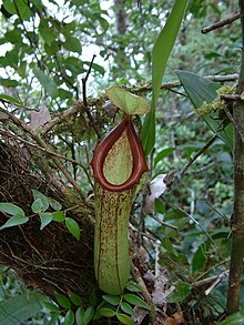
The carnivorous pitcher plant Nepenthes insignis grows on Biak.
The rain forest-covered Biak Islands have been designated the Biak-Numfoor rain forests, especially as they have the largest number of endemic bird species of any single area in the New Guinea region. There are also numerous reptile and amphibian species found here. Among the many snake species catalogued by Tom Mendelson during his herpetological survey of Biak in the 1990s, the green tree python (Morelia viridis) and the amethystine python (Morelia amethystina) were quite common.
There are numerous types of flora in the tropical rain forest of the island, including a variety of trees and other commercially important species plus the lush vegetation of mangrove swamps.[citation needed]
See also
- 1996 Biak earthquake
References
^ Kratoska, Paul H. (2001). South East Asia, Colonial History: Imperialism before 1800, Volume 1 de South East Asia, Colonial History. Taylor & Francis. p. 56. ISBN 9780415215404..mw-parser-output cite.citation{font-style:inherit}.mw-parser-output .citation q{quotes:"""""""'""'"}.mw-parser-output .citation .cs1-lock-free a{background:url("//upload.wikimedia.org/wikipedia/commons/thumb/6/65/Lock-green.svg/9px-Lock-green.svg.png")no-repeat;background-position:right .1em center}.mw-parser-output .citation .cs1-lock-limited a,.mw-parser-output .citation .cs1-lock-registration a{background:url("//upload.wikimedia.org/wikipedia/commons/thumb/d/d6/Lock-gray-alt-2.svg/9px-Lock-gray-alt-2.svg.png")no-repeat;background-position:right .1em center}.mw-parser-output .citation .cs1-lock-subscription a{background:url("//upload.wikimedia.org/wikipedia/commons/thumb/a/aa/Lock-red-alt-2.svg/9px-Lock-red-alt-2.svg.png")no-repeat;background-position:right .1em center}.mw-parser-output .cs1-subscription,.mw-parser-output .cs1-registration{color:#555}.mw-parser-output .cs1-subscription span,.mw-parser-output .cs1-registration span{border-bottom:1px dotted;cursor:help}.mw-parser-output .cs1-ws-icon a{background:url("//upload.wikimedia.org/wikipedia/commons/thumb/4/4c/Wikisource-logo.svg/12px-Wikisource-logo.svg.png")no-repeat;background-position:right .1em center}.mw-parser-output code.cs1-code{color:inherit;background:inherit;border:inherit;padding:inherit}.mw-parser-output .cs1-hidden-error{display:none;font-size:100%}.mw-parser-output .cs1-visible-error{font-size:100%}.mw-parser-output .cs1-maint{display:none;color:#33aa33;margin-left:0.3em}.mw-parser-output .cs1-subscription,.mw-parser-output .cs1-registration,.mw-parser-output .cs1-format{font-size:95%}.mw-parser-output .cs1-kern-left,.mw-parser-output .cs1-kern-wl-left{padding-left:0.2em}.mw-parser-output .cs1-kern-right,.mw-parser-output .cs1-kern-wl-right{padding-right:0.2em}
^ Coello, Francisco "Notas sobre los planos de las bahias descubiertas, en el año 1606, en las islas de Espíritu Santo y de Nueva Guinea, que dibujo el capitán don Diego de Prado y Tovar, en igual fecha" Boletín de la Sociedad Geográfica de Madrid, t IV, primer semestre de 1878, p.234.
^ Luis Filipe F. R. Thomaz, The image of the Archipelago in Portuguese cartography of the 16th and early 17th centuries, Persee, 1995, Volume 49 pages: 79–124
^ Kilvert, Andrew (1998-10-11). "Behind The Biak Massacre". Asia Pacific Network. Archived from the original on December 18, 2001. Retrieved 2007-01-22.
^ Barclay, Paul (1 August 2008). "The Biak Massacre". RadioNational: Perspective. Australian Broadcasting Corporation. Retrieved 2012-02-20.
^ http://sp2010.bps.go.id/files/ebook/9409.pdf
^ ab "Biak". WMO. Retrieved 30 May 2016.
^ John J. Klein (2006). Space Warfare: Strategy, Principles, and Policy. McGraw Hill Professional. p. 85. ISBN 978-0-415-77001-9.


