Cornhill, Boston

Cornhill, Boston, 1962
Cornhill was a street in Boston, Massachusetts, in the 19th and 20th centuries, located on the site of the current City Hall Plaza in Government Center. It was named in 1829; previously it was known as Market Street (1807-1828).[1][2] In its time, it comprised a busy part of the city near Brattle Street, Court Street and Scollay Square. In the 19th century, it was the home of many bookstores and publishing companies.[3] As of 1969, Cornhill exists as 144 feet along the edge of City Hall Plaza.[4]
See also
- City Hall Plaza
Sears' Crescent building (built 1816) 100 City Hall Plaza; formerly 38-68 Cornhill)[5][6]
Sears' Block (built 1848) corner Court + Washington St., formerly 70-72 Cornhill[5][6]
- Previous tenants of Cornhill
Annin & Smith, 19th-century engravers[7]
Iver Johnson Sporting Goods Company, Located in the Iver Johnson Building, corner of Washington Street and Cornhill
Daniel Clement Colesworthy, bookseller, c. 1850s[8]
Frost & Adams, art supplies
The Liberator (anti-slavery newspaper), published by Isaac Knapp, Cornhill, c. 1837[9]
Bela Marsh, 19th century publisher
F.T. Somerby, painter
Images

Detail of 1826 map of Boston, showing Market Street (renamed Cornhill in 1828)

Detail of 1832 map of Boston, showing Cornhill and vicinity

Cornhill, c. 1836. Shows shops of Light & Horton; Gerry & Burt; George W. Light; Peck & Co.; William Peirce; etc.

Advertising for the Prisoner's Friend published on Cornhill, c. 1840s. "Devoted to the abolition of capitol punishment, and the improvement of prison discipline"

Advertisement for George C. Rand & Co. printers, 1849
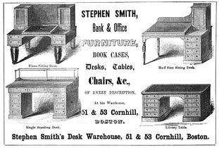
Advertisement for Stephen Smith's Desk Warehouse, 1854

Whig Headquarters, 1856
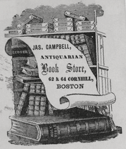
Ad for James Campbell, antiquarian bookshop, c. 1860s[10]

c. 1897

Cornhill, Boston, c. 1905
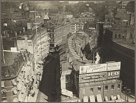
Overview of Brattle St. (left), Cornhill (right), and Faneuil Hall (upper right), c. 1920


References
^ Edward Hartwell Savage (1886), Boston events, Boston: Mutual News Co..mw-parser-output cite.citation{font-style:inherit}.mw-parser-output q{quotes:"""""""'""'"}.mw-parser-output code.cs1-code{color:inherit;background:inherit;border:inherit;padding:inherit}.mw-parser-output .cs1-lock-free a{background:url("//upload.wikimedia.org/wikipedia/commons/thumb/6/65/Lock-green.svg/9px-Lock-green.svg.png")no-repeat;background-position:right .1em center}.mw-parser-output .cs1-lock-limited a,.mw-parser-output .cs1-lock-registration a{background:url("//upload.wikimedia.org/wikipedia/commons/thumb/d/d6/Lock-gray-alt-2.svg/9px-Lock-gray-alt-2.svg.png")no-repeat;background-position:right .1em center}.mw-parser-output .cs1-lock-subscription a{background:url("//upload.wikimedia.org/wikipedia/commons/thumb/a/aa/Lock-red-alt-2.svg/9px-Lock-red-alt-2.svg.png")no-repeat;background-position:right .1em center}.mw-parser-output .cs1-subscription,.mw-parser-output .cs1-registration{color:#555}.mw-parser-output .cs1-subscription span,.mw-parser-output .cs1-registration span{border-bottom:1px dotted;cursor:help}.mw-parser-output .cs1-hidden-error{display:none;font-size:100%}.mw-parser-output .cs1-visible-error{font-size:100%}.mw-parser-output .cs1-subscription,.mw-parser-output .cs1-registration,.mw-parser-output .cs1-format{font-size:95%}.mw-parser-output .cs1-kern-left,.mw-parser-output .cs1-kern-wl-left{padding-left:0.2em}.mw-parser-output .cs1-kern-right,.mw-parser-output .cs1-kern-wl-right{padding-right:0.2em}
^ From 1708 to 1824, a portion of Washington Street was known as "Cornhill;" cf. Boston (Mass.). Street laying-out Dept. (1910), A record of the streets, alleys, places, etc. in the city of Boston (2 ed.), Boston: City of Boston Printing Dept.
^ "Cornhill – Once Boston's Literary Center, Today Replaced by Government Center". Forgotten New England. Retrieved 10 May 2016.
^ "Public way. Open from Franklin Ave to approximately 144 feet easterly." cf. "Street Book". City of Boston. Retrieved 2010-06-17.
^ ab "National Register of Historic Places". U.S. Dept. of the Interior. Retrieved 2010-06-17.
^ ab Susan Southworth; Michael Southworth (2008), AIA guide to Boston (3 ed.), Guilford, Conn: Globe Pequot, OCLC 175057014
^ Boston Directory. 1832
^ Boston Directory. 1857
^ American Broadsides and Ephemera, Series 1, no. 5153
^ Boston Directory. 1861
Further reading
- "Old Boston Booksellers: the Three Burnham Brothers and their Antecedents." New York Times, July 21, 1893. (Mentions Samuel B. Drake and Burnham Brothers, booksellers).
External links
| Wikimedia Commons has media related to Cornhill (Boston, Massachusetts). |
Bostonian Society has materials related to the street.
G.Kepes. Photo of Scollay Square From Pemberton Square Looking Across to Cornhill Street, 1957.- Flickr. Sears Crescent, 1999
- Flickr. Sears Crescent, 2008
- Flickr. Photo, 2009
Coordinates: 42°21′34.58″N 71°3′27.81″W / 42.3596056°N 71.0577250°W / 42.3596056; -71.0577250


