Nakhon Ratchasima
Nakhon Ratchasima นครราชสีมา | ||
|---|---|---|
City Municipality | ||
| City of Nakhon Ratchasima เทศบาลนครนครราชสีมา | ||
     (From top, left to right): Thao Suranaree Monument Downtown, 80th Birthday Stadium, CentralPlaza Nakhon Ratchasima, The City Gate, and Nakhon Ratchasima railway station | ||
| ||
| Nickname(s): Korat | ||
 Nakhon Ratchasima Location in Thailand | ||
| Coordinates: 14°58′50″N 102°6′00″E / 14.98056°N 102.10000°E / 14.98056; 102.10000 | ||
| Country | Thailand | |
| Province | Nakhon Ratchasima | |
| District | Mueang Nakhon Ratchasima | |
| - Settled | 1656 (Ayutthaya Period) | |
| - as Sanitary districts | 3 Jan 1908 | |
| - as Municipality | 7 Dec 1935 | |
| Government | ||
| • Type | City Municipality | |
| • Mayor | Surawuth Cherdchai | |
| • Municipal Clerk | Arlom Tangtaku | |
| Area | ||
| • City Municipality | 37.5 km2 (14.5 sq mi) | |
| • Land | 37.4 km2 (14.45 sq mi) | |
| • Metro | 767.98 km2 (296.52 sq mi) | |
| Population (2011) | ||
| • City Municipality | 166,217 | |
| • Density | 4,432.45/km2 (11,480.0/sq mi) | |
| • Metro | 444,023 | |
| • Metro density | 578.17/km2 (1,497.5/sq mi) | |
| • Demonym | Korat | |
| Time zone | UTC+7 (ICT) | |
| Area code | (+66) 44 | |
| Website | koratcity.go.th | |

Nakhon Ratchasima (Thai: นครราชสีมา, pronounced [ná(ʔ).kʰɔ̄ːn râːt.t͡ɕʰā.sǐː.māː]) is one of the four major cities of Isan, Thailand, known as the "big four of Isan". The city is commonly known as Korat (โคราช, pronounced [kʰōː.râːt]), a shortened form of its name. It is the governmental seat of the Nakhon Ratchasima Province and Mueang Nakhon Ratchasima District. Nakhon Ratchasima is the heart of the Nakhon Ratchasima metropolitan area.
Korat is at the western edge of the Korat Plateau. Historically, it once marked the boundary between Lao and Siamese territory. It is the gateway to the Lao-speaking northeast (Isan). Its location is 14°58.5′N 102°6′E / 14.9750°N 102.100°E / 14.9750; 102.100Coordinates: 14°58.5′N 102°6′E / 14.9750°N 102.100°E / 14.9750; 102.100. As of 2010[update], the municipal area had a population of 142,645.[1]
Contents
1 Etymology
2 History
3 Climate
4 Economy
4.1 Retail
5 Transport
5.1 Air
5.2 Rail
5.3 Road
6 Education
6.1 Universities
6.2 Schools
6.3 International schools
7 Hospitals
8 Sports
9 Media
10 See also
11 References
12 External links
Etymology
Archeological evidence suggests that in Sung Noen District, 32 km west of present-day Nakhon Ratchasima (Korat) there were two ancient towns called Sema ("Bai sema" (ใบเสมา) are notable artifacts of the Korat plateau)[2] and Khorakapura. (Pali púra becomes Sanskrit puri, hence Thai บุรี, บูรี (buri), all connoting the same as Thai mueang: "city with defensive wall".) N The latter name was shortened to Nakhon Raj. (Nakhon (นคร) derives from Sanskrit nagara (नगर), "city"; Raj (ราช), from Sanskrit Raj, "sovereign.") The present city name is a portmanteau of Nakhon Raj and Sema.
The city is commonly known as "Korat" (Thai: โคราช), which is a short version of the ancient Khmer name "ankor raj".
History
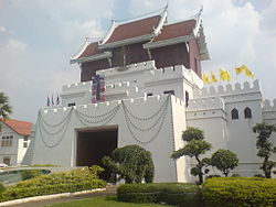
Ya Mo Entrance Gate at the junction of Ratchadamnoen Rd and Hwy 224
Prior to the 14th century, the area of Nakhon Ratchasima was under Khmer empire suzerainty and known in Khmer as Angkor raj, Nokor Reach Seyma, or Nokor Reach Borei, and Koreach. Phimai, to the north, was probably more important.
King Narai of Ayutthaya in the 17th century, ordered a new city built on the site to serve as a stronghold on Ayutthaya's northeastern frontier. Nakhon Ratchasima was thereafter mentioned in Siamese chronicles and legal documents as a "second-class" city of the Ayutthaya Kingdom. A royal governor ruled the city in a hereditary position.
After the final phase of the Ayutthaya kingdom ended with its complete destruction by the Burmese in 1767, a son of King Boromakot attempted to set himself up ruler in Phimai, holding sway over Korat and other eastern provinces. King Taksin of the Thonburi Kingdom (1768–1782) sent two of his generals, brothers Thong Duang and Boonma, to defeat the prince, who was executed in 1768. Thong Duang later became King Rama I of the kingdom, and Korat became his strategic stronghold on the northeastern frontier to supervise the Lao and Khmer tributary states.

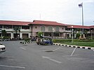
Nakhon Ratchasima Railway Station
In 1826, Vientiane King Chao Anouvong, perceiving Siam as weakened, attacked Korat in the Laotian Rebellion against King Rama III that was to rage on for two years.[3]Lady Mo, the wife of the deputy governor at the time, is credited with having freed the city from Anouvong's army, and has been honored with a statue in the center of downtown Korat. A full account of the war and its impact on Laos and Siam, is detailed in the book, Lady Mo and Heroism at Tung Samrit, written by Frank G Anderson. The city's old wall, east of the monument was designed and built by a French engineer who is believed to be the one who also built Naraimaharaj Palace in Lopburi. The French-based design is reflected in the moat system that surrounds the innermost portion of the city.
Nakhon Ratchasima continued to be an important political and economic center in the northeastern region under the Monthon administrative reforms of the late-19th century. In November 1900, the Royal State Railways of Siam began operation of the Nakhon Ratchasima Line from Bangkok with Korat Station as its terminus. The Ubon Ratchathani Line to the town of Warin opened 1 November 1922. The Thanon Chira Junction to Khon Kaen opened on 1 April 1933. Korat station was changed to Nakhon Ratchasima Railway Station in 1934.
In October 1933, after the Siamese revolution of 1932 ended the absolute monarchy, the city became the headquarters of the Boworadet Rebellion, an abortive uprising against the new government in Bangkok.[citation needed]
In April 1981 during another attempted coup, the government, together with the royal family, took refuge in Korat.[citation needed]
From 1962-1976, during the Vietnam War, Korat Royal Thai Air Force Base hosted components of the Royal Thai Air Force, the United States Air Force, and a complement of the Royal New Zealand Air Force (RNZAF). After the US withdrawal in 1976, the Thai Air Force assumed full control. During the 1980s and early-1990s, the airfield was jointly operated as a civil airport for Nakhon Ratchasima. This ended with the opening of Nakhon Ratchasima Airport in the early-1990s.
On 13 August 1993, Thailand's worst hotel disaster happened in the city, the collapse of the Royal Plaza Hotel, killing 137 people.[4]

Climate
There are generally three seasons in the region: Hot (February - May), Rainy (May - October), Cold (October - February). In the cold season, minimum temperatures in Korat proper will drop to about 18 °C (64 °F), and in rural areas, down to about 12 °C (54 °F).
| Climate data for Nakhon Ratchasima (1981–2010) | |||||||||||||
|---|---|---|---|---|---|---|---|---|---|---|---|---|---|
| Month | Jan | Feb | Mar | Apr | May | Jun | Jul | Aug | Sep | Oct | Nov | Dec | Year |
| Record high °C (°F) | 37.7 (99.9) | 39.4 (102.9) | 40.8 (105.4) | 42.2 (108.0) | 41.4 (106.5) | 39.2 (102.6) | 39.2 (102.6) | 37.2 (99.0) | 36.7 (98.1) | 35.1 (95.2) | 36.1 (97.0) | 36.0 (96.8) | 42.2 (108.0) |
| Average high °C (°F) | 30.7 (87.3) | 33.6 (92.5) | 35.6 (96.1) | 36.5 (97.7) | 35.0 (95.0) | 34.4 (93.9) | 33.8 (92.8) | 33.2 (91.8) | 32.2 (90.0) | 31.0 (87.8) | 30.1 (86.2) | 29.3 (84.7) | 33.0 (91.4) |
| Daily mean °C (°F) | 24.3 (75.7) | 26.9 (80.4) | 28.9 (84.0) | 30.0 (86.0) | 29.1 (84.4) | 29.1 (84.4) | 28.6 (83.5) | 28.1 (82.6) | 27.4 (81.3) | 26.7 (80.1) | 25.4 (77.7) | 23.6 (74.5) | 27.3 (81.1) |
| Average low °C (°F) | 18.5 (65.3) | 21.0 (69.8) | 23.2 (73.8) | 24.9 (76.8) | 25.0 (77.0) | 25.1 (77.2) | 24.7 (76.5) | 24.5 (76.1) | 24.0 (75.2) | 23.2 (73.8) | 21.1 (70.0) | 18.3 (64.9) | 22.8 (73.0) |
| Record low °C (°F) | 9.6 (49.3) | 12.4 (54.3) | 13.0 (55.4) | 19.0 (66.2) | 21.5 (70.7) | 22.0 (71.6) | 21.3 (70.3) | 21.7 (71.1) | 20.4 (68.7) | 16.6 (61.9) | 12.5 (54.5) | 8.3 (46.9) | 8.3 (46.9) |
| Average rainfall mm (inches) | 8.2 (0.32) | 16.1 (0.63) | 37.1 (1.46) | 72.2 (2.84) | 154.1 (6.07) | 104.5 (4.11) | 120.9 (4.76) | 157.2 (6.19) | 228.3 (8.99) | 146.3 (5.76) | 23.9 (0.94) | 2.7 (0.11) | 1,071.5 (42.19) |
| Average rainy days | 1.0 | 2.3 | 5.4 | 8.4 | 13.9 | 12.9 | 14.3 | 17.3 | 18.6 | 12.3 | 3.9 | 0.9 | 111.2 |
| Average relative humidity (%) | 64 | 62 | 61 | 65 | 73 | 72 | 73 | 75 | 80 | 78 | 71 | 66 | 70 |
| Mean monthly sunshine hours | 226.3 | 211.9 | 201.5 | 186.0 | 155.0 | 114.0 | 117.8 | 117.8 | 108.0 | 145.7 | 186.0 | 226.3 | 1,996.3 |
| Mean daily sunshine hours | 7.3 | 7.5 | 6.5 | 6.2 | 5.0 | 3.8 | 3.8 | 3.8 | 3.6 | 4.7 | 6.2 | 7.3 | 5.5 |
| Source #1: Thai Meteorological Department[5] | |||||||||||||
| Source #2: Office of Water Management and Hydrology, Royal Irrigation Department (sun and humidity)[6] | |||||||||||||
Economy
Korat's economy has traditionally been heavily dependent on agriculture. It is known as a processing centre for Isan's production of rice, tapioca, and sugar. The Isan region accounts for half of Thailand's exports of those commodities. Together, these three agricultural commodities employ 700,000 Isan families. Korat is also one of two sites in Thailand manufacturing disk drives by Seagate Technology, employing 12,100 workers in Korat.[7][8]
Retail
Korat has become the commercial hub, not only for Isan, but also for neighbouring Cambodia and Laos. All three of Thailand's largest Bangkok-based department store chains have invested in expansive outlets in the city, which will boast one million square metres of retail space by late 2017.[7]
Transport

Songthaew Rte 4129 waits on Ratchadamnoen Rd. This one goes to Korat Zoo via The Mall
Air
Nakhon Ratchasima Airport lies 26 km east of the city.[9] There are no scheduled air services operating from the airport.
Rail
Nakhon Ratchasima is on the northeastern railway line, connecting Bangkok with Ubon Ratchathani and Nong Khai. There are two main railway stations in the city: Nakhon Ratchasima Railway Station on Mukkhamontri Road and Thanon Chira Junction Railway Station on Watcharasarit Road. In 2017, a 60-kilometre dual-track line will connect Korat to Khon Kaen. It is the first segment of a dual track network that will connect Isan with the Laem Chabang seaport.[7]
Road
Passing near the city is Mittraphap Road (Thailand Route 2). A new motorway connecting Korat to Bangkok is under construction in 2016 and will reduce travel time on the 250 kilometre journey to just over two hours.[7]
Education

Statue of Lady Mo, Korat city centre.
Universities
There are four universities in the area.
- Suranaree University of Technology
- Nakhon Ratchasima Rajabhat University
- Rajamangala University of Technology Isan
- Vongchavalitkul University
Schools
- Saint Mary's College Nakhon Ratchasima
- Suratham Pitak School
- Rajsima Wittayalai School
- Suranaree Witthaya School
- Suranaree 2 Nakhon Ratchasima
- Boonwattana School
- St.Mary Business Administration College
- Assumption College Nakhonratchasima
- Marie vitthaya School Nakhon Ratchasima
- Sarasas Witaed Nakhon Ratchasima
- Koratpittayakom Nakhon Ratchasima
International schools
Anglo Singapore International School (Korat Campus)
Hospitals

Bangkok-Ratchasima Hospital
- Fort Suranaree Hospital
- Saint Mary's Hospital
- Korat Memorial Hospital
- Bangkok-Ratchasima Hospital
- Po-Pat Hospital
- Po-Pat 2 Hospital
- Maharat Nakhon Ratchasima Hospital
- The Golden Gate Hospital
Sports

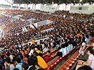
His Majesty the King's 80th Birthday Anniversary, 5 December 2007 Sports Complex.
The 80th Birthday Stadium is the main stadium in His Majesty the King's 80th Birthday Anniversary, 5th December 2007 Sports Complex. It is home to Nakhon Ratchasima FC who competes in the national first tier football level, Thailand Premier League and it was used for the 2007 Southeast Asian Games.
The stadium is in the former SEA Games sports complex on Highway 304 (Pak Thong Chai Road) to the southwest of the city. The stadium is all-seats with a capacity of 20,000.
Nakhon Ratchasima is the home of the four-times Men's Volleyball Thailand League winner, Nakhon Ratchasima the Mall and the three-times Women's Volleyball Thailand League winner, Nakhon Ratchasima the Mall
Media
Korat's daily Thai newspaper is The Korat Daily. An English language newspaper, The Korat Post, is published monthly. What's on Korat is an English website and Facebook page that focuses on up to date news on events, food, drink, sports and local services in English. "Expats in Korat / Nakhon Ratchasima" is a very active Facebook group for asking any questions about life in Korat.
See also
- Nakhon Ratchasima Province
- List of Cities, Towns and Townships in Nakhon Ratchasima Province
Korat (cat)
References
^ Department of Provincial Administration, Ministry of Interior, Royal Thai Government. 16 August 2010
^ Phetsanghan, Phairot; Chantachon, Songkoon; Yodmalee, Boonsom (2009). "Sema Hin Isan, the Origin of the Temple Boundary Stones in north-east Thailand". The Social Sciences. Medwell Journals. 4 (2): 186–190. Archived from the original on July 31, 2013. Retrieved January 4, 2015..mw-parser-output cite.citation{font-style:inherit}.mw-parser-output .citation q{quotes:"""""""'""'"}.mw-parser-output .citation .cs1-lock-free a{background:url("//upload.wikimedia.org/wikipedia/commons/thumb/6/65/Lock-green.svg/9px-Lock-green.svg.png")no-repeat;background-position:right .1em center}.mw-parser-output .citation .cs1-lock-limited a,.mw-parser-output .citation .cs1-lock-registration a{background:url("//upload.wikimedia.org/wikipedia/commons/thumb/d/d6/Lock-gray-alt-2.svg/9px-Lock-gray-alt-2.svg.png")no-repeat;background-position:right .1em center}.mw-parser-output .citation .cs1-lock-subscription a{background:url("//upload.wikimedia.org/wikipedia/commons/thumb/a/aa/Lock-red-alt-2.svg/9px-Lock-red-alt-2.svg.png")no-repeat;background-position:right .1em center}.mw-parser-output .cs1-subscription,.mw-parser-output .cs1-registration{color:#555}.mw-parser-output .cs1-subscription span,.mw-parser-output .cs1-registration span{border-bottom:1px dotted;cursor:help}.mw-parser-output .cs1-ws-icon a{background:url("//upload.wikimedia.org/wikipedia/commons/thumb/4/4c/Wikisource-logo.svg/12px-Wikisource-logo.svg.png")no-repeat;background-position:right .1em center}.mw-parser-output code.cs1-code{color:inherit;background:inherit;border:inherit;padding:inherit}.mw-parser-output .cs1-hidden-error{display:none;font-size:100%}.mw-parser-output .cs1-visible-error{font-size:100%}.mw-parser-output .cs1-maint{display:none;color:#33aa33;margin-left:0.3em}.mw-parser-output .cs1-subscription,.mw-parser-output .cs1-registration,.mw-parser-output .cs1-format{font-size:95%}.mw-parser-output .cs1-kern-left,.mw-parser-output .cs1-kern-wl-left{padding-left:0.2em}.mw-parser-output .cs1-kern-right,.mw-parser-output .cs1-kern-wl-right{padding-right:0.2em}
^ Chandler, David P.; Roff, William R.; Smail, John R.W.; Steinberg, David Joel; Taylor, Robert H.; Woodside, Alexander & Wyatt, David K. (1987) [1971]. "13 Siam, 1767–1868". In David, Steinberg. In search of south-east Asia (Revised ed.). Honolulu: University of Hawaii Press. pp. 113–117. ISBN 0-8248-1110-0. OCLC 500095794. Lay summary (January 8, 2008).
^ "Court orders five to pay Bt152 million compensation for Korat Hotel collapse". The Nation. 7 March 2009. Retrieved 9 May 2015.
^ "Climatological Data for the Period 1981–2010". Thai Meteorological Department. p. 12. Retrieved 2 August 2016.
^ "ปริมาณการใช้น้ำของพืชอ้างอิงโดยวิธีของ Penman Monteith (Reference Crop Evapotranspiration by Penman Monteith)" (PDF) (in Thai). Office of Water Management and Hydrology, Royal Irrigation Department. p. 59. Retrieved 2 August 2016.
^ abcd Janssen, Peter (2 November 2016). "Thailand takes a long-term gamble on Isaan region". Nikkei Asian Review. Retrieved 3 November 2016.
^ Temphairojana, Pairat (2015-02-10). "Seagate to invest $470 mln in Thailand over next 5 years". Reuters. Retrieved 3 November 2016.
^ "Nakhon Ratchasima Airport". Flightstats.com. Retrieved 29 April 2012.
External links
| Wikimedia Commons has media related to Nakhon Ratchasima. |
- What's On Korat (www.whatsonkorat.com) is an online English guide to Korat / Nakhon Ratchasima with an up to date Facebook page
 Nakhon Ratchasima travel guide from Wikivoyage
City of Nakhon Ratchasima | |||||||
|---|---|---|---|---|---|---|---|
History | |||||||
| Government and localities |
|  | |||||
| Buildings and landmarks |
| ||||||
| Economy |
| ||||||
| Transport |
| ||||||
| Culture |
| ||||||
| Education |
| ||||||
| Other topics |
| ||||||
Capitals of provinces of Thailand | ||
|---|---|---|
| ||
| 1,000,000 and more |
|
|---|---|
| 500,000–999,999 |
|
| 200,000–499,999 |
|
| 100,000–299,999 |
|
Authority control |
|
|---|


