Merkys
| Merkys | |
|---|---|
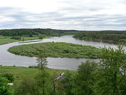 Confluence of the Merkys and Neman at Merkinė | |
| Country | Lithuania (3,781 km2 or 1,460 sq mi), Belarus (635 km2 or 245 sq mi) |
| Physical characteristics | |
| Main source | 18 km (11 mi) southwest from Ašmiany, Belarus 136 m (446 ft) |
| River mouth | Neman near Merkinė |
| Length | 213 km (132 mi) |
| Discharge |
|
| Basin features | |
| Basin size | 4,416 km2 (1,705 sq mi) |
The Merkys (Belarusian: Мяркіс Miarkis) is a river in southern Lithuania and northern Belarus. It flows for 13 km (8 mi) through Belarus, 5 km (3 mi) along the Belarusian–Lithuanian border, and 195 km (121 mi) through Lithuania before joining the Nemunas near Merkinė.
Merkys is mostly fed by underground streams and therefore is cooler during summers and has smaller fluctuations in water level than other rivers in Lithuania.[1] Near Žagarinė (128 km or 80 mi before its mouth) the Merkys is connected with Lake Papys by a canal. The Vokė originates from this lake and consumes most of the Merkys' water. Before the canal average discharge of the Merkys is 3 m3/s (110 cu ft/s) and below it only 0.7 m3/s (25 cu ft/s).[1] At the end of the 19th century the drainage basin of the Merkys grew by some 410 km2 (160 sq mi) as its tributary Ūla River overtook some of the Kotra's watershed area.[1]
The Merkys is a popular destination among water tourism enthusiasts as part of it belongs to the Dzūkija National Park and it flows into the Neman near the historical site of Merkinė. Archaeological findings show that people inhabited the area as early as the Mesolithic period. The Merkys is known for its diverse fauna, being declared a reservoir for trout in 1974.[1]
Name
The name of the river, Merkys, originate from merkti, an appellative word in the Lithuanian language meaning to soak.[2]
References
| Wikimedia Commons has media related to Merkys. |
^ abcd Jonas Zinkus; et al., eds. (1987). "Merkys". Tarybų Lietuvos enciklopedija (in Lithuanian). III. Vilnius, Lithuania: Vyriausioji enciklopedijų redakcija. pp. 54–55..mw-parser-output cite.citation{font-style:inherit}.mw-parser-output q{quotes:"""""""'""'"}.mw-parser-output code.cs1-code{color:inherit;background:inherit;border:inherit;padding:inherit}.mw-parser-output .cs1-lock-free a{background:url("//upload.wikimedia.org/wikipedia/commons/thumb/6/65/Lock-green.svg/9px-Lock-green.svg.png")no-repeat;background-position:right .1em center}.mw-parser-output .cs1-lock-limited a,.mw-parser-output .cs1-lock-registration a{background:url("//upload.wikimedia.org/wikipedia/commons/thumb/d/d6/Lock-gray-alt-2.svg/9px-Lock-gray-alt-2.svg.png")no-repeat;background-position:right .1em center}.mw-parser-output .cs1-lock-subscription a{background:url("//upload.wikimedia.org/wikipedia/commons/thumb/a/aa/Lock-red-alt-2.svg/9px-Lock-red-alt-2.svg.png")no-repeat;background-position:right .1em center}.mw-parser-output .cs1-subscription,.mw-parser-output .cs1-registration{color:#555}.mw-parser-output .cs1-subscription span,.mw-parser-output .cs1-registration span{border-bottom:1px dotted;cursor:help}.mw-parser-output .cs1-hidden-error{display:none;font-size:100%}.mw-parser-output .cs1-visible-error{font-size:100%}.mw-parser-output .cs1-subscription,.mw-parser-output .cs1-registration,.mw-parser-output .cs1-format{font-size:95%}.mw-parser-output .cs1-kern-left,.mw-parser-output .cs1-kern-wl-left{padding-left:0.2em}.mw-parser-output .cs1-kern-right,.mw-parser-output .cs1-kern-wl-right{padding-right:0.2em}
^ Zinkevičius, Zigmas (2007). Senosios Lietuvos valstybės vardynas. Vilnius: Science and Encyclopaedia Publishing Institute. p. 48. ISBN 5-420-01606-0.
Coordinates: 54°09′23″N 24°11′07″E / 54.15639°N 24.18528°E / 54.15639; 24.18528
Tributaries of the Neman River | ||
|---|---|---|
| Main tributaries of the left bank |
|  |
| Main tributaries of the right bank |
| |
| Distributary |
| |
This article related to a river in Lithuania is a stub. You can help Wikipedia by expanding it. |
This article related to a river in Belarus is a stub. You can help Wikipedia by expanding it. |

