Białystok Voivodeship (1919–1939)
See also: Białystok Voivodeship (1945–1975) and Białystok Voivodeship (1975–1998)
| Białystok Voivodeship Województwo białostockie | |||||
Voivodeship of Poland | |||||
| |||||
 Coat of arms Coat of arms | |||||
 within the Second Polish Republic, 1938. | |||||
Capital | Białystok | ||||
Government | Voivodeship | ||||
Voivode | |||||
| • | 1919–1920 | Stefan Badzynski | |||
| • | 1937–1939 | Henryk Ostaszewski | |||
History | |||||
| • | Established | 14 August 1919 | |||
| • | Annexed | September 1939 | |||
Area | |||||
| • | 1921 | 32,450 km2(12,529 sq mi) | |||
| • | 1939 | 26,036 km2(10,053 sq mi) | |||
Population | |||||
| • | 1921 | 1,305,284 | |||
Density | 40.2 /km2 (104.2 /sq mi) | ||||
| • | 1931 | 1,263,300 | |||
Political subdivisions | 13 counties (powiaty) (1919–38) 10 counties (1938–1939) | ||||
Białystok Voivodeship (Polish: Województwo białostockie) was an administrative unit of interwar Poland (1918–1939). The province's capital and its biggest city was Białystok with the population of over 91,000 people. Following the Nazi German and the Soviet invasion of Poland, the Voivodeship was occupied by both invading armies and divided according to Nazi-Soviet boundary treaty.
Contents
1 Area and location
2 Population
3 History
4 Administrative divisions
4.1 1919–1938
4.2 1938–1939
5 Cities and towns
6 Railroads and industry
7 Voivodes
8 Notes
9 References
Area and location
In interwar Poland (1918–1939), Bialystok Voivodeship was located in mid-northern part of the country. It bordered Germany (East Prussia) to north-west, Lithuania to north-east, Wilno Voivodeship and Nowogródek Voivodeship to the east, Polesie Voivodeship and Lublin Voivodeship to the south and Warsaw Voivodeship to the west. Its area was 26 036 km². Landscape was flat, with the mighty Bialowieza Forest located right in the middle.
Population
Inhabited mostly by Poles (in 1931 they made up 66.9% of the population), it also had significant Belarusian (16.3%) and Jewish (12.1%) minorities. Interesting is the fact that in 1931, 2.8% claimed Russian as their native tongue. The population, according to the 1931 Polish census was 1 263 300.
According to Polish data from April 1939, the population of Białystok voivodship was divided as follows: 71,1% Poles, 13,5% Belarusians, 11,9% Jews, 2,2% Russians, 0,9% Lithuanians, 0,5% Germans.[1]
History
From 10 July 1930 to the end of February 1934, Marian Zyndram-Kościałkowski was the Voivode of Białystok. During this time, he streamlined administration, increased supervision of officials, and prioritized the development of sewers and streets in Bialystok. He also founded the Regional Committee for Unemployment, as well as had their share in the creation of the Agricultural Chamber of Białystok and ensuring the participation of entrepreneurs in the second Bialystok Fair Vilnius. He was also one of the founders of Jagiellonia Białystok Sports Club (of which he was honorary president of the club).[2]
In November 1930, Marian Zyndram-Kościałkowski once again became a member of Parliament (he was 17th on the list of the Nonpartisan Bloc for Cooperation with the Government (BBWR).[3]
In 1932, Zyndram-Kościałkowski remained at the disposal of the Head of the Department and the Ministry of Defense Corps.
Administrative divisions
|
|
Cities and towns

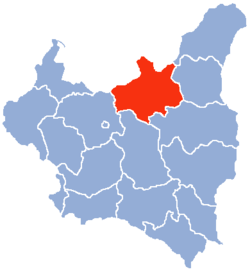
Counties of the Białystok Voivodeship from 1919–1921 and 1922–1939.
The Voivodeship consisted of thirteen counties (powiaty):
According to the 1931 census, the biggest cities were:
- Bialystok (pop. 91 100),
- Grodno (pop. 49 700),
- Suwalki (pop. 21 800),
- Wolkowysk (pop. 15 100),
- Augustow (pop. 12 100).
Railroads and industry
In the interwar period, Białystok Voivodeship was part of the so-called "Poland B". This meant that it was underdeveloped, with 23.1% of the population being illiterate. Railroad networks were scarce (total length 1 377 km., density - 4.2 per 100 km²), and forested areas covered 24.4% of Voivodeship's area. The city of Białystok (whose population reached 107 000 in 1939), was the Voivodeship's lone industrial center. Agriculture was at a low level.
Voivodes
- Stefan Badzynski, 19 November 1919 – 18 October 1920
- Stefan Kołek, May 1920 – September 1920 (acting)
- Stefan Popielawski, September 1920 – 12 July 1924 (till 3 November 1920 - acting)
- Marian Rembowski, 12 August 1924 – 24 November 1927
- Karol Kirst, 24 November 1927 – 10 July 1930
Marian Zyndram-Kościałkowski, 10 July 1930 – 8 March 1934- Stanisław Michałowski, 8 March 1934 – 29 September 1934 (acting)
- Stefan Pasławski, 29 September 1934 – 14 July 1936
- Stefan Kirtiklis, 17 July 1936 – 9 September 1937
- Henryk Ostaszewski, 9 November 1937 – 10 September 1939 (till 22 December 1937 acting)
Notes
^ (in Polish) D. Boćkowski. Na zawsze razem. Białostocczyzna i Łomżyńskie w polityce radzieckiej w czasie II wojny światowej (IX 1939 – VIII 1944). Neriton, Instytut Historii PAN. 2005. pp. 116-117.
^ "Jak to z władzami bywało..." (in Polish)..mw-parser-output cite.citation{font-style:inherit}.mw-parser-output q{quotes:"""""""'""'"}.mw-parser-output code.cs1-code{color:inherit;background:inherit;border:inherit;padding:inherit}.mw-parser-output .cs1-lock-free a{background:url("//upload.wikimedia.org/wikipedia/commons/thumb/6/65/Lock-green.svg/9px-Lock-green.svg.png")no-repeat;background-position:right .1em center}.mw-parser-output .cs1-lock-limited a,.mw-parser-output .cs1-lock-registration a{background:url("//upload.wikimedia.org/wikipedia/commons/thumb/d/d6/Lock-gray-alt-2.svg/9px-Lock-gray-alt-2.svg.png")no-repeat;background-position:right .1em center}.mw-parser-output .cs1-lock-subscription a{background:url("//upload.wikimedia.org/wikipedia/commons/thumb/a/aa/Lock-red-alt-2.svg/9px-Lock-red-alt-2.svg.png")no-repeat;background-position:right .1em center}.mw-parser-output .cs1-subscription,.mw-parser-output .cs1-registration{color:#555}.mw-parser-output .cs1-subscription span,.mw-parser-output .cs1-registration span{border-bottom:1px dotted;cursor:help}.mw-parser-output .cs1-hidden-error{display:none;font-size:100%}.mw-parser-output .cs1-visible-error{font-size:100%}.mw-parser-output .cs1-subscription,.mw-parser-output .cs1-registration,.mw-parser-output .cs1-format{font-size:95%}.mw-parser-output .cs1-kern-left,.mw-parser-output .cs1-kern-wl-left{padding-left:0.2em}.mw-parser-output .cs1-kern-right,.mw-parser-output .cs1-kern-wl-right{padding-right:0.2em}
^ Chojnowski, Andrzej; Wróbel, Piotr (1992). "Marian Zyndram-Kościałkowski, premier Rzeczypospolitej 13 X 1935 – 15 V 1936". Prezydenci i premierzy Drugiej Rzeczypospolitej (in Polish). Wrocław – Warszawa – Kraków: Zakład Narodowy imienia Ossolińskich. p. 349. ISBN 978-83-04-03854-7.
References
Maly rocznik statystyczny, Warszawa 1939 (Concise Statistical Year-Book of Poland, Warsaw 1939). (in Polish)
| City Voivodeship |
|  |
|---|---|---|
| Land Voivodeships |
| |
| Autonomous Voivodeships | Silesian | |
| Planned Voivodeships |
| |
Authority control |
|
|---|


