Mateh Asher Regional Council
Mateh Asher
| |
|---|---|
 | |
| District | Northern |
| Government | |
| • Type | Regional council (from 1982) |
| • Head of Municipality | Moshe Davidovich |
| Area | |
| • Total | 212,150 dunams (212.15 km2 or 81.91 sq mi) |
| Population (2014) | |
| • Total | 25,800 |
| • Density | 120/km2 (310/sq mi) |
| Website | Official website |
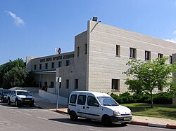
The Mateh Asher Regional Council (Hebrew: מועצה אזורית מטה אשר, Mo'atza Azorit Mateh Asher) is a regional council in the western Galilee of northern Israel. It is named after the Tribe of Asher which had been allotted the region in antiquity according to the Book of Joshua (19:24-31). It was founded in 1982 as a merger of three regional councils: Ga'aton, Na'aman and Sulam Tzor. The council's offices are located on Highway 4, between Regba and Lohamei HaGeta'ot.
The regional council was established in 1982, now stretches over 216,059 dunams and includes some 17,300 residents.[1] As of 2008, the head of the regional council is Yehuda Shavit, and the chief rabbi is Rabbi Shlomo Ben Eliyahu.
Contents
1 List of settlements
1.1 Kibbutzim
1.2 Moshavim
1.3 Community settlements and villages
1.4 Arab villages
2 International relations
3 References
4 External links
List of settlements
This regional council provides municipal services for the populations within its territory, who live in various types of communities including kibbutzim and moshavim, Arab villages, and community and other settlements:
Kibbutzim
|
|
|
|
Moshavim
|
|
|
|
Community settlements and villages
- Klil
- Nes Ammim
- Oshrat
Arab villages
- Arab al-Aramshe
- Sheikh Danun
International relations
Mateh Asher is twin towns with following cities and districts:[2]
(in German): Oldenburg, since 1996
References
^ "Local Authorities in Israel 2005, Publication #1295 - Municipality Profiles - Mateh Asher" (PDF) (in Hebrew). Israel Central Bureau of Statistics. Retrieved 2008-02-14..mw-parser-output cite.citation{font-style:inherit}.mw-parser-output .citation q{quotes:"""""""'""'"}.mw-parser-output .citation .cs1-lock-free a{background:url("//upload.wikimedia.org/wikipedia/commons/thumb/6/65/Lock-green.svg/9px-Lock-green.svg.png")no-repeat;background-position:right .1em center}.mw-parser-output .citation .cs1-lock-limited a,.mw-parser-output .citation .cs1-lock-registration a{background:url("//upload.wikimedia.org/wikipedia/commons/thumb/d/d6/Lock-gray-alt-2.svg/9px-Lock-gray-alt-2.svg.png")no-repeat;background-position:right .1em center}.mw-parser-output .citation .cs1-lock-subscription a{background:url("//upload.wikimedia.org/wikipedia/commons/thumb/a/aa/Lock-red-alt-2.svg/9px-Lock-red-alt-2.svg.png")no-repeat;background-position:right .1em center}.mw-parser-output .cs1-subscription,.mw-parser-output .cs1-registration{color:#555}.mw-parser-output .cs1-subscription span,.mw-parser-output .cs1-registration span{border-bottom:1px dotted;cursor:help}.mw-parser-output .cs1-ws-icon a{background:url("//upload.wikimedia.org/wikipedia/commons/thumb/4/4c/Wikisource-logo.svg/12px-Wikisource-logo.svg.png")no-repeat;background-position:right .1em center}.mw-parser-output code.cs1-code{color:inherit;background:inherit;border:inherit;padding:inherit}.mw-parser-output .cs1-hidden-error{display:none;font-size:100%}.mw-parser-output .cs1-visible-error{font-size:100%}.mw-parser-output .cs1-maint{display:none;color:#33aa33;margin-left:0.3em}.mw-parser-output .cs1-subscription,.mw-parser-output .cs1-registration,.mw-parser-output .cs1-format{font-size:95%}.mw-parser-output .cs1-kern-left,.mw-parser-output .cs1-kern-wl-left{padding-left:0.2em}.mw-parser-output .cs1-kern-right,.mw-parser-output .cs1-kern-wl-right{padding-right:0.2em}
^ Description of international cooperation at the official website of the city of Oldenburg (in German)
External links
- Official website
Northern District of Israel | ||
|---|---|---|
| Cities |
|  |
| Local councils |
| |
| Regional councils |
| |
Coordinates: 32°58′13.12″N 35°5′37.32″E / 32.9703111°N 35.0937000°E / 32.9703111; 35.0937000