Zielona Góra
Zielona Góra | |||
|---|---|---|---|
| |||
| |||
| Motto(s): Miasto przyszłości City of the future | |||
 Zielona Góra Show map of Lubusz Voivodeship  Zielona Góra Show map of Poland  Zielona Góra Show map of Europe | |||
| Coordinates: 51°56′N 15°30′E / 51.933°N 15.500°E / 51.933; 15.500 | |||
| Country | Poland | ||
| Voivodeship | Lubusz | ||
| Established | 13th century | ||
| Town rights | 1323 | ||
| Government | |||
| • Mayor | Janusz Kubicki | ||
| Area | |||
| • Total | 278.32 km2 (107.46 sq mi) | ||
| Elevation | 71 m (233 ft) | ||
| Population (2017) | |||
| • Total | 139,813 [1] | ||
| • Density | 498/km2 (1,290/sq mi) | ||
| Time zone | UTC+1 (CET) | ||
| • Summer (DST) | UTC+2 (CEST) | ||
| Postal code | 65-001 to 65-950 | ||
| Area code(s) | +48 068 | ||
| Car plates | FZ | ||
| Climate | Cfb | ||
| Website | http://www.zielona-gora.pl/ | ||


Zielona Góra [ʑeˈlɔna ˈɡura] (![]() listen) (German: Grünberg in Schlesien) is the largest city in Lubusz Voivodeship, in western Poland, with 139,813 inhabitants (2017). Zielona Góra has been in Lubusz Voivodeship since 1999, prior to which it was the capital of Zielona Góra Voivodeship from 1950 to 1998. It is the seat of the province's elected assembly, while the seat of the centrally appointed governor is located in the city of Gorzów Wielkopolski. Zielona Góra has a favourable geographical position, being located not far from the Polish-German border and on several international road and rail routes connecting Scandinavia with Southern Europe[2] and Warsaw with Berlin.[3] The region is also closely associated with vineyards and holds an annual Wine Fest.[4]
listen) (German: Grünberg in Schlesien) is the largest city in Lubusz Voivodeship, in western Poland, with 139,813 inhabitants (2017). Zielona Góra has been in Lubusz Voivodeship since 1999, prior to which it was the capital of Zielona Góra Voivodeship from 1950 to 1998. It is the seat of the province's elected assembly, while the seat of the centrally appointed governor is located in the city of Gorzów Wielkopolski. Zielona Góra has a favourable geographical position, being located not far from the Polish-German border and on several international road and rail routes connecting Scandinavia with Southern Europe[2] and Warsaw with Berlin.[3] The region is also closely associated with vineyards and holds an annual Wine Fest.[4]
The city's history began when Polish Duke Henry the Bearded brought first settlers to the area in 1222.[4] In 1323 Zielona Góra was granted town privileges and subsequently passed to Bohemia in 1335. In 1526 it became part of the Habsburg Empire and experienced a wave of witch trials in the 17th century. As a result of the First Silesian War, Zielona Góra was annexed by Prussia and remained in Germany until the end of World War II in 1945.[4] In accordance with the Potsdam Agreement, the province was handed over to Poland and resettled with Poles, most of whom came from Central Poland, but some also had been expelled from the Eastern Borderlands.
Zielona Góra is surrounded by tree-covered hills and the adjacent woodland alone makes up approximately half of the city's total area. The name of the city itself translates to 'Green Mountain' in both Polish and German.[2] Moreover, Zielona Góra features several tourist attractions and important historical sites including the preserved medieval Old Town, 13th-century Market Square, tenements, palaces, parks and the famous Palm House on Wine Hill. Its strong connection to vineyards and grape-picking earned Zielona Góra a nickname "The City of Wine".[5]
Contents
1 History
2 Wineries
3 Climate
4 Education
4.1 Secondary education
4.2 Universities and colleges
5 Transport
6 Events
7 Sports
8 International relations
8.1 Twin towns — Sister cities
9 People
10 Image gallery
11 References
11.1 Bibliography
11.2 Notes
12 External links
History
The first settlement in the area of Zielona Góra was built in the valley near the Złota Łącza stream during the reign of Polish ruler Mieszko I.[6] The oldest settlement was agricultural and later developed into a trading point along routes from Poznań to Żagań and further to Łużyce.[6] The written records of the Slavic settlement date to 1222 and an increase of its population by Henry the Bearded.[6] Other documents date the settlement to 1302.[7]

Panorama of city in mid-18th century

Timber-framed Catholic church
The region received influx of German burghers in the second half of the 13th century during the medieval Ostsiedlung.[8] The settlement became a city with Crossener Recht, a variation of Magdeburg rights, in 1323.[7] The earliest mention of the town's coat of arms is from 1421, although it is believed to have been arranged since the beginning of the 14th century.[9] A document in the town archive of Thorn (Toruń) dating from before 1400 used a sigil with the name GRVNINBERG, an early form of the German name Grünberg.[9]
In 1294, Duke Henryk III of Głogów, founded a church in honour of Saint Hedwig, patron saint of Silesia. This building, today called the konkatedra św. Jadwigi w Zielonej Górze, is the oldest building in the city. A wooden castle near the city, built ca. 1272, was the residence of Duke Janusz of Ścinawa from 1358 to 1365; Janusz had ceded his lands to Duke Henry V of Glogau.[10] In 1477 the town defeated a 5,000-strong army from neighbouring Brandenburg which attempted to seize it during the succession war to the Duchy of Glogau. In 1488, Duke Janusz II of Żagań (Sagan), destroyed the castle to prevent his enemies from using it.[10]

The original marketplace with historical tenement houses spared from destruction during World War II
After the collapse of the Duchy of Sagan, the town fell to the Kingdom of Bohemia, a state of the Holy Roman Empire. Grünberg converted to Lutheranism during the Protestant Reformation through the efforts of Paul Lemberg, Abbot of Sagan.[11] The city declined during the 17th century, especially during the Thirty Years' War (1618–48) and following decades. Grünberg endured plundering, debts, emigration of burghers, and fires.[11] In 1651 during the Counter Reformation, the Habsburg Monarchy of Austria reintroduced Roman Catholicism and suppressed Protestantism.[10] The city was subjected to heavy Germanisation and German craftsmen banned Poles from attending any practice allowing them to work as members of guilds.[6] A rebellion caused by conscription ended with many Poles being imprisoned.[6]
The city was annexed by the Kingdom of Prussia by the 1742 Treaty of Breslau which ended the First Silesian War. The Prussians introduced religious toleration,[11] leading to the construction of the Protestant parish church Zum Garten Christ from 1746 to 1747;[11] Catholic Poles were later discriminated against, however. The city's textile industry was booming by the end of the 18th century, and by 1800 large parts of the city walls had been dismantled to allow the city to expand.[11] The textile industry suffered during the 1820s while adjusting to the Industrial Revolution and an import ban by the Russian Empire. The city's economy began to recover after many clothiers emigrated to Congress Poland.

Concert Hall
During industrialisation, many Germans from the countryside moved to large industrial cities and a large number of Poles came to German cities to work as well. The Polish population was pushed by Germanisation to rural villages,[6] although some remained in the town contributed to the economic revival of the city.[6] A Polish church remained functional[6] until 1809 and a Polish craftsmen association (Towarzystwo Polskich Rzemieślników) was established by Kazimierz Lisowski in 1898; it existed till 1935 when Lisowski was murdered by the Gestapo.
Since 1816 after the Napoleonic Wars, Grünberg was administered within the district Landkreis Grünberg in the Province of Silesia. In 1871 it became part of the German Empire during the unification of Germany. English industrialists purchased some of the city's textile factories during the 1870s and 1880s.[11] By 1885, most of Grünberg's population of 14,396 were Protestants.[12] The city was first connected to the Glogau-Grünberg-Guben railway line in 1871, followed by connections to Christianstadt in 1904, Wollstein in 1905, and a local line to Sprottau in 1911.[11]

Local museum
In 1919, Grünberg became part of the Province of Lower Silesia within Weimar Germany. On 1 April 1922 it became a district-free city, but this status was revoked on 1 October 1933 while part of Nazi Germany.
The Soviet Red Army occupied Grünberg with little fighting in February 14, 1945 during World War II.[11] In that course, about 500 people committed suicide.[13] The following month, the town was placed under Polish administration, followed by the post-war Potsdam Agreement. The remaining German inhabitants who had not fled from the Eastern Front were expelled, and the town was partly resettled with Poles transferred from Polish areas annexed by the Soviet Union. The city was officially renamed from the German name Grünberg to the Polish name Zielona Góra — both of which mean "Green Mountain" — and the 18th-century Protestant church was reconsecrated as a Catholic church (Kościół Matki Boskiej Częstochowskiej).
The University of Zielona Góra was opened in 2001. The city is also the seat of the Roman Catholic Diocese of Zielona Góra-Gorzów.
Wineries
The city has been known for its wines for centuries. It is now one of two places in Poland with wine grape cultivation mainly for white wines (the other being the wine growing region near the town of Warka in Masovia). The first wineries around the city were built in 1314. At Paradyż (Paradise) Abbey near Zielona Góra, monks have been making wine since 1250. The number of vineyards at peak production is estimated at 4,000 in the region, and 2,500 in Zielona Góra itself. During the communist era wine production was reduced, but since 1990 it has recovered. Since 1852 an annual Wine Festival has taken place in the town. However, nowadays wine is no longer produced in Zielona Góra itself (the last factory was closed in the early 1990s).
Vodka Luksusowa (namely: Luxury vodka), made from potatoes rather than grain, is produced in distillery in Zielona Góra.

Climate
The climate is oceanic (Köppen: Cfb) with some humid continental characteristics (Dfb) in normals previous to 1981-2010. Despite being some distance from the sea, western standards as well as air masses are still predominant in the western than eastern, not very different from German cities near the border.[14]
| Climate data for Zielona Gora (Słowackiego), elevation: 192 m, 1961-1990 normals and extremes | |||||||||||||
|---|---|---|---|---|---|---|---|---|---|---|---|---|---|
| Month | Jan | Feb | Mar | Apr | May | Jun | Jul | Aug | Sep | Oct | Nov | Dec | Year |
| Record high °C (°F) | 13.0 (55.4) | 19.0 (66.2) | 24.2 (75.6) | 30.4 (86.7) | 30.9 (87.6) | 33.3 (91.9) | 35.3 (95.5) | 34.8 (94.6) | 32.0 (89.6) | 27.6 (81.7) | 19.8 (67.6) | 15.4 (59.7) | 35.3 (95.5) |
| Average high °C (°F) | 0.6 (33.1) | 2.4 (36.3) | 7.0 (44.6) | 12.5 (54.5) | 18.2 (64.8) | 21.4 (70.5) | 22.9 (73.2) | 22.5 (72.5) | 18.4 (65.1) | 13.0 (55.4) | 6.3 (43.3) | 2.3 (36.1) | 12.3 (54.1) |
| Daily mean °C (°F) | −1.8 (28.8) | −0.6 (30.9) | 3.0 (37.4) | 7.6 (45.7) | 13.0 (55.4) | 16.4 (61.5) | 17.8 (64.0) | 17.3 (63.1) | 13.7 (56.7) | 9.0 (48.2) | 3.8 (38.8) | 0.0 (32.0) | 8.3 (46.9) |
| Average low °C (°F) | −4.1 (24.6) | −3.1 (26.4) | −0.2 (31.6) | 3.7 (38.7) | 8.5 (47.3) | 11.9 (53.4) | 13.5 (56.3) | 13.1 (55.6) | 10.1 (50.2) | 6.1 (43.0) | 1.5 (34.7) | −2.2 (28.0) | 4.9 (40.8) |
| Record low °C (°F) | −22.2 (−8.0) | −21.3 (−6.3) | −17.2 (1.0) | −5.8 (21.6) | −3.4 (25.9) | 2.2 (36.0) | 6.9 (44.4) | 4.5 (40.1) | 1.1 (34.0) | −4.6 (23.7) | −12.4 (9.7) | −20.1 (−4.2) | −22.2 (−8.0) |
| Average precipitation mm (inches) | 36 (1.4) | 32 (1.3) | 32 (1.3) | 42 (1.7) | 60 (2.4) | 62 (2.4) | 67 (2.6) | 71 (2.8) | 44 (1.7) | 43 (1.7) | 45 (1.8) | 48 (1.9) | 582 (23) |
| Average precipitation days (≥ 1.0 mm) | 9.3 | 8.2 | 8.2 | 8.3 | 9.5 | 9.2 | 9.4 | 8.8 | 7.7 | 7.4 | 9.2 | 10.9 | 106.1 |
| Source: NOAA[15] | |||||||||||||
Education

Music school

University of Zielona Góra
The city has a university and a College of International Trade and Finance. Currently there are 18,000 students studying in the city.
Secondary education
Secondary education is based on the High School type of educational facility.
- I High School
- III High School
- IV High School
- V High School
- seventh General Lyceum
- Schools of Electronics
- Schools of Economics
Universities and colleges
University of Zielona Góra [1]
- College of International Trade and Finance
Transport
Zielona Góra Airport is located at Babimost, north-east of the city. It is currently the eleventh busiest airport in Poland, in terms of traffic size. Formerly a military base, it has become an important transport hub for western Poland. LOT Polish Airlines currently offers daily flights to Warsaw.

Main train station in Zielona Góra
Zielona Góra has train connections to Gorzów Wielkopolski, Zbąszynek, Rzepin, Warsaw, Frankfurt (Oder) and Krakow, main cities of the surrounding regions: Poznań, Szczecin and Wrocław as well as direct international connections to Berlin, Vienna.
The city lies at the junction of National Road 3, National Road 27 and National Road 32 and is a major interchange on S3 Expressway along European route E65.
Events
- June/July: Busker Bus Festival
- August: Folk Song and Dance Festival Folk Festival
- September: Winobranie (Wine Fest)
Sports
The city is home to Basket Zielona Góra, reigning champion of the Polish Basketball League and member of the European Basketball Champions League. The team plays its home games at the CRS Hall Zielona Góra.
International relations

Zielona Góra's twin towns
Twin towns — Sister cities
Zielona Góra is twinned with:[16]
|
|
People

Maryla Rodowicz was born in Zielona Góra
Bartholomaeus Pitiscus (born 1561; died 1613), mathematician, theologian, astronomer
Abraham Scultetus (born 1566; died 1625), theologian
Rudolf Haym (born 1821; died 1901), philosopher
Wilhelm Foerster (born 1832; died 1921), astronomer
Otto Julius Bierbaum (born 1865; died 1910), writer
Franz Mattenklott (1884–1954), general
Prince Franz Wilhelm of Prussia (born 1943) great-grandson of Kaiser Wilhelm II.
Maryla Rodowicz (born 1945), singer
Jürgen Colombo (born 1949), bicyclist
Maria Gładkowska (born 1957), actress
Olga Tokarczuk (born 1962), journalist
Tomasz Lis (born 1966), journalist
Mariusz Linke (born 1969), mixed martial arts fighter and world-class grappler
Grzegorz Halama (born 1970), comedian
Piotr Protasiewicz 1975, Speedway Rider
Grzegorz Zengota 1988, Speedway Rider
Renata Thiele, German writer
| Historical population | ||
|---|---|---|
| Year | Pop. | ±% |
| 1740 | 3,494 | — |
| 1843 | 10,405 | +197.8% |
| 1900 | 20,983 | +101.7% |
| 1939 | 26,076 | +24.3% |
| 1946 | 15,738 | −39.6% |
| 1957 | 45,127 | +186.7% |
| 1965 | 62,844 | +39.3% |
| 1975 | 84,230 | +34.0% |
| 1985 | 109,926 | +30.5% |
| 2001 | 119,152 | +8.4% |
| 2007 | 117,532 | −1.4% |
| 2012 | 119,182 | +1.4% |
| 2017 | 139,813 | +17.3% |
| Note: 2010[19] 2014[20] 2017[2] | ||
Image gallery

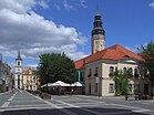
Town hall on market square

St Hedwig's Cathedral

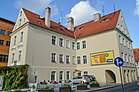
Lofts in Zielona Góra
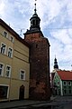
The Hunger Tower from the 15th century

Astronomical observatory

Palm house with restaurant on vine hill

Zielona Góra Main Library
Independence Avenue in the city centre

Lutheran church in Zielona Góra

University Hospital

14th-century chapel
City map

Grünberg on Blaeu's 1645 map of Lower Silesia

In Blaeu's 1645 atlas (spelled Grūberg with a macron)
Grünberg on the German map of 1905


References
Bibliography
.mw-parser-output .refbegin{font-size:90%;margin-bottom:0.5em}.mw-parser-output .refbegin-hanging-indents>ul{list-style-type:none;margin-left:0}.mw-parser-output .refbegin-hanging-indents>ul>li,.mw-parser-output .refbegin-hanging-indents>dl>dd{margin-left:0;padding-left:3.2em;text-indent:-3.2em;list-style:none}.mw-parser-output .refbegin-100{font-size:100%}
Hupp, Otto (1896). Königreich Preußen: Wappen der Städte. Flecken und Dörfer (in German). Frankfurt: Verlag von Heinrich Keller. p. 185..mw-parser-output cite.citation{font-style:inherit}.mw-parser-output .citation q{quotes:"""""""'""'"}.mw-parser-output .citation .cs1-lock-free a{background:url("//upload.wikimedia.org/wikipedia/commons/thumb/6/65/Lock-green.svg/9px-Lock-green.svg.png")no-repeat;background-position:right .1em center}.mw-parser-output .citation .cs1-lock-limited a,.mw-parser-output .citation .cs1-lock-registration a{background:url("//upload.wikimedia.org/wikipedia/commons/thumb/d/d6/Lock-gray-alt-2.svg/9px-Lock-gray-alt-2.svg.png")no-repeat;background-position:right .1em center}.mw-parser-output .citation .cs1-lock-subscription a{background:url("//upload.wikimedia.org/wikipedia/commons/thumb/a/aa/Lock-red-alt-2.svg/9px-Lock-red-alt-2.svg.png")no-repeat;background-position:right .1em center}.mw-parser-output .cs1-subscription,.mw-parser-output .cs1-registration{color:#555}.mw-parser-output .cs1-subscription span,.mw-parser-output .cs1-registration span{border-bottom:1px dotted;cursor:help}.mw-parser-output .cs1-ws-icon a{background:url("//upload.wikimedia.org/wikipedia/commons/thumb/4/4c/Wikisource-logo.svg/12px-Wikisource-logo.svg.png")no-repeat;background-position:right .1em center}.mw-parser-output code.cs1-code{color:inherit;background:inherit;border:inherit;padding:inherit}.mw-parser-output .cs1-hidden-error{display:none;font-size:100%}.mw-parser-output .cs1-visible-error{font-size:100%}.mw-parser-output .cs1-maint{display:none;color:#33aa33;margin-left:0.3em}.mw-parser-output .cs1-subscription,.mw-parser-output .cs1-registration,.mw-parser-output .cs1-format{font-size:95%}.mw-parser-output .cs1-kern-left,.mw-parser-output .cs1-kern-wl-left{padding-left:0.2em}.mw-parser-output .cs1-kern-right,.mw-parser-output .cs1-kern-wl-right{padding-right:0.2em}
Stier, Erich; Ernst Kirsten; Wilhelm Wühr; Heinz Quirin; Werner Trillmilch; Gerhard Czybulka; Hermann Pinnow; Hans Ebeling (1963). Westermanns Atlas zur Weltgeschichte: Vorzeit / Altertum, Mittelalter, Neuzeit (in German). Braunschweig: Georg Westermann Verlag. p. 170.
Weczerka, Hugo (1977). Handbuch der historischen Stätten Deutschlands, Schlesien (in German). Stuttgart: Alfred Kröner Verlag. p. 699. ISBN 3-520-31601-3.
Notes
^ "Powierzchnia i ludność w przekroju terytorialnym w 2015 r." Stat.gov.pl. Retrieved 24 September 2017.
^ abc Witosławska, Agata. "Zielona Gora - the city of the future". Retrieved 24 September 2017.
^ o.o., StayPoland Sp. z. "Zielona Gora - Tourism - Tourist Information - Zielona Gora, Poland -". Staypoland.com. Retrieved 24 September 2017.
^ abc "Zielona Góra and surrounding areas : Brochure" (PDF). Weisswasser,de. Retrieved 29 December 2018.
^ "Qubus Hotel Zielona Góra - The city's attractions". Qubushotel.com. Retrieved 24 September 2017.
^ abcdefgh Municipal homepage (in Polish)
^ ab Weczerka, p. 164
^ Westermann, p. 74
^ ab Hupp, p. 154
^ abc Weczerka, p. 165
^ abcdefgh Weczerka, p. 166
^ Meyers Konversations-Lexikon, 1885
^ Lakotta, Beate (2005-03-05). "Tief vergraben, nicht dran rühren" (in German). SPON. Retrieved 2010-08-16.
^ "Zielona Gora, Poland Köppen Climate Classification (Weatherbase)". Weatherbase. Retrieved 2018-12-31.
^ "Zielona Góra (12400) - WMO Weather Station". NOAA. Retrieved December 31, 2018.
Archived December 27, 2018, at the Wayback Machine.
^ abcdefghijklm "Zielona Góra Miasta partnerskie". Urząd Miasta Zielona Góra. Retrieved 2013-06-24.
^ "Our twin cities- Cottbus". Cottbus.de. Archived from the original on 2013-11-04. Retrieved 2013-06-24.
^ Офіційний сайт міста Івано-Франківська. mvk.if.ua (in Ukrainian). Retrieved 7 March 2010.
^ "Ludność w gminach. Stan w dniu 31 marca 2011 r. – wyniki spisu ludności i mieszkań 2011 r." Główny Urząd Statystyczny. Archived from the original on 27 November 2011. Retrieved 20 August 2012.
^ "Population in Poland. Size and structure by territorial division as of December 31, 2015" (ASPX) (in Polish). Retrieved 26 May 2016.
External links
| Wikimedia Commons has media related to Zielona Góra. |
Grünberg church records of births, marriages and deaths since 1582- Municipal website
- Zielona Góra University
- Mobile news for Zielona Góra
Jewish Community in Zielona Góra on Virtual Shtetl
The Death March through Zielona Góra to Volary, at Yad Vashem website
Grünberg Notgeld (emergency banknotes) depicting various episodes from the region's history. webgerman.com/Notgeld/
Counties of Lubusz Voivodeship | ||
|---|---|---|
| City counties |
|  |
| Land counties |
| |
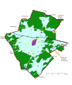
Zielona Góra County | ||
|---|---|---|
Seat (not part of the county): Zielona Góra | ||
| Urban-rural gminas |
|  |
| Rural gminas |
| |
Coordinates: 51°56′N 15°30′E / 51.933°N 15.500°E / 51.933; 15.500
Authority control |
|
|---|


