Barpeta district
Barpeta district | |
|---|---|
District | |
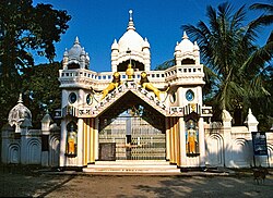 Sankardev Satra Patbausi temple | |
 Barpeta district's location in Assam | |
| Coordinates: 26°32′N 91°00′E / 26.533°N 91.000°E / 26.533; 91.000Coordinates: 26°32′N 91°00′E / 26.533°N 91.000°E / 26.533; 91.000 | |
| Country | India |
| State | Assam |
| Division | Lower Assam |
| Headquarters | Barpeta |
| Area | |
| • Total | 3,245 km2 (1,253 sq mi) |
| Population (2011) | |
| • Total | 1,693,190 |
| • Density | 520/km2 (1,400/sq mi) |
| Time zone | UTC+05:30 (IST) |
| ISO 3166 code | IN-AS-BA |
| Website | http://barpeta.gov.in/ |
Barpeta district {Pron:bə(r)ˈpeɪtə or bə(r)ˈpi:tə} is an administrative district in the state of Assam in India. The district headquarters are located at Barpeta. The district occupies an area of 3245 km² and has a population of 1,642,420 (as of 2001.)
Contents
1 History
2 Geography
3 Important towns of the district
4 Economy
5 Divisions
6 Demographics
7 References
8 External links
History
Barpeta district was created in 1983 when it was split from Kamrup district.[1]
Geography
Barpeta district occupies an area of 3,245 square kilometres (1,253 sq mi),[2] comparatively equivalent to Russia's Iturup Island.[3] Barpeta district shares an international border with Bhutan in the north.
Important towns of the district
- Barpeta
- The headquarters and the second largest town in the district. A Medical College is established named "Fakharuddin Ali Ahmed Medical College"- FAAMC. It is virtually a noise and pollution free town with a limited number of automobiles. The town is surrounded by rivulets and canals from all directions. The most important centre of attraction is the Barpeta satra established by Great Vaishnavite saint Madhabdev. A few years ago, it was also famous for transport industry. However, it has faded a little bit now. It was also famous for ivory working, which is now almost extinct.
- Howly
- The middle town of the district between Barpeta Road and Barpeta Town. It is a busy commercial town that is also known as the business capital of the district. Many indigenous Assamese communities live peacefully in and around the town.Assam's largest Rash Mela held here. Many communities of people of Assam participate in this Rash Mela. 31 no. national highway run through this town. A majority of the people in the town have higher education. It is the only town where beetle nut (Supari) produce. Many beetle nut industries situated here.
- Barpeta Road
- The largest town of the district. It is a busy commercial town that is also known as the business capital of Western Assam. Many indigenous Assamese communities live peacefully in and around the town.
- Sarbhog
- A small town along national highway no. 31 that is known for its famous tasty curd made from buffalo's milk. Many institutions are located in and around the town.
- Padma Para
- A small and beautiful village situated in the south east corner of Barpeta town.This place is Famous for well known Padmapara High School, Md Mulam Khan was the established as well as the first Headmaster of this School. B.P.Janakalyan library is also present here which was established in 1952. Md Mulam Khan, Abdus Sattar Bhuyan and Abu Tabel are three famous persons of this place.
- Bahari
Bahari is one of the important place of Barpeta district. It is situated in the south east corner of Barpeta, near about 20 km away from the main town. Brahmaputra river is flowing in the south side of Bahari. Bahari is famous for the weekly market which is held in every Thursday. It is also the commercial hub for the entire south eastern part of Barpeta district. People from Nalbari district as well as other district come to here for commercial purpose. Specially jute, mustard, rice, sweet products, vegetables are sells here. Bahari is also famous for the Satra which is establish by Mahapurux Sri Sri Haridev. Mainly indigenous Assamese communities live here. The well known Bahari High School is also present here.
- Pathsala
- A town in the eastern part of the district is also known as the Hollywood of mobile theaters of Assam. Base camps of many famous and old mobile theatre groups of Assam are situated in the town. A majority of the people in the town have higher education. It is home to many indigenous Assamese communities like Keots/Kaibarta, Bodo, etc.
- Patacharkuchi
- Patacharkuchi is a town in Barpeta district, Assam, India. Patacharkuchi is strategically placed on the bank of beautiful, amusing, inviting river Kaldia. In the early 19th century, a dak bungalow (a rest camp for the Post man and Government officers) and a thana (police station) was established by the British. This was the only police station in Bajali circle.
- Barmara
- A small village situated as a transit point between Chenga and Rouly. It is known for its biweekly markets that cater to all the needs of poor and lower middle class people.
- Sarthebari
- A small town known for its bell-metal works.
- Kalgachia
- A Town in the west of the district, mainly the people of Assamese Muslims. This is an important center for educational and intellectual activities of the Muslims of Assam
- Bhawanipur
- A town situated near NH31 and the center place of Barpeta District. It has a good Communication System for the people. It is a well-educated and well-populated town. Mainly indigenous Assamese people and members of the Bangledeshi immigrant people live in the town. The town is known for Bhawanipuria Gopal Ataa Satra and for Sahid Khargeswar Talukdar.
- Sarupeta
- A town situated near Bhawanipur Town. It is mainly known as place of business and there is a railway station.
- Jania
- Jania Bazar is situated near FAAM Medical College, Barpeta.
- Chenga
Chenga is situated in the east part of Barpeta.well known Madhya Kamrup College is present here. Bhari dhuwa ghat of Mahapurux Sankardev is present here. The Hova Mahutshab which is held on the occasion of Magh Bihu is famous among the people of Barpeta.
- Nagaon
- A small town situated in the east side of the Barpeta town . Well known for the B.B.K. COLLEGE present here.
- Barbhitha
- A village of south west border of Barpeta District, well known for famous Barbhitha High School and journalist Main Uddin.
- Mandia
- Mandia is another town in the south part of the district. Many educational institutions are in the area, Jebi.
- Jania & Kadong
- Jania and Kadong are peaceful village in the district. The river Beki also flows through Kadong. In jania a oldest satra and namghar situated in the village, Jebi aHmed.
- Dimapur
- Dimapur is a small village situated in the western part of the district. It is known for the Lokpriya Girls College and the Rainbow Human Development Society. It is largely Rajidul Islam
- Balaipather
- Balaipather is the biggest village situated in the western part of district.
- Mandia
- Mandia is the high populated village in the district. It is known for Mandia Ancholik College, Mandia Jame Majjid. River Bhelengi flow through this village.
- Habi Radhakuchi
- Habi Radhakuchi is the small village in eastern side of Barpeta district. The village is famous for Habi Radhakuchi Anchalic Bazar . This is the only Marketing place in 6 No. Radhakuchi G.P. The village is also femous for 346 No. Habi Radhakuchi L.P.School. the school is established in 1946.
Economy
In 2006 the Indian government named Barpeta one of the country's 250 most backward districts (out of a total of 640.)[4] It is one of the eleven districts in Assam currently receiving funds from the Backward Regions Grant Fund Programme (BRGF.)[4]
Divisions
There are eight Assam Legislative Assembly constituencies in this district, the Barpeta, Baghbor, Bhawanipur, Chenga, Jania, Patacharkuchi, Sarukhetri, Sorbhog.[5] Sorbhog is in the Kokrajhar Lok Sabha constituency, whilst the other five are in the Barpeta Lok Sabha constituency.[6]
Demographics
According to the 2011 census, the Barpeta district has a population of 1,693,190,[7] roughly equal to the nation of Guinea-Bissau[8] or the US state of Idaho.[9] This gives it a ranking of 292nd in India (out of a total of 640.)[7] The district has a population density of 632 inhabitants per square kilometre (1,640/sq mi).[7] Its population growth rate over the decade 2001–2011 was 21.4%.[7] Barpeta has a sex ratio of 951 females for every 1000 males,[7] and a literacy rate of 65.03%.[7] In this district mainly indigenous Mia Muslim settlement place, except for some bodo, Keots/Kaibarta, etc.
References
^ Law, Gwillim (25 September 2011). "Districts of India". Statoids. Retrieved 11 October 2011..mw-parser-output cite.citation{font-style:inherit}.mw-parser-output .citation q{quotes:"""""""'""'"}.mw-parser-output .citation .cs1-lock-free a{background:url("//upload.wikimedia.org/wikipedia/commons/thumb/6/65/Lock-green.svg/9px-Lock-green.svg.png")no-repeat;background-position:right .1em center}.mw-parser-output .citation .cs1-lock-limited a,.mw-parser-output .citation .cs1-lock-registration a{background:url("//upload.wikimedia.org/wikipedia/commons/thumb/d/d6/Lock-gray-alt-2.svg/9px-Lock-gray-alt-2.svg.png")no-repeat;background-position:right .1em center}.mw-parser-output .citation .cs1-lock-subscription a{background:url("//upload.wikimedia.org/wikipedia/commons/thumb/a/aa/Lock-red-alt-2.svg/9px-Lock-red-alt-2.svg.png")no-repeat;background-position:right .1em center}.mw-parser-output .cs1-subscription,.mw-parser-output .cs1-registration{color:#555}.mw-parser-output .cs1-subscription span,.mw-parser-output .cs1-registration span{border-bottom:1px dotted;cursor:help}.mw-parser-output .cs1-ws-icon a{background:url("//upload.wikimedia.org/wikipedia/commons/thumb/4/4c/Wikisource-logo.svg/12px-Wikisource-logo.svg.png")no-repeat;background-position:right .1em center}.mw-parser-output code.cs1-code{color:inherit;background:inherit;border:inherit;padding:inherit}.mw-parser-output .cs1-hidden-error{display:none;font-size:100%}.mw-parser-output .cs1-visible-error{font-size:100%}.mw-parser-output .cs1-maint{display:none;color:#33aa33;margin-left:0.3em}.mw-parser-output .cs1-subscription,.mw-parser-output .cs1-registration,.mw-parser-output .cs1-format{font-size:95%}.mw-parser-output .cs1-kern-left,.mw-parser-output .cs1-kern-wl-left{padding-left:0.2em}.mw-parser-output .cs1-kern-right,.mw-parser-output .cs1-kern-wl-right{padding-right:0.2em}
^ Srivastava, Dayawanti et al. (ed.) (2010). "States and Union Territories: Assam: Government". India 2010: A Reference Annual (54th ed.). New Delhi, India: Additional Director General, Publications Division, Ministry of Information and Broadcasting (India), Government of India. p. 1116. ISBN 978-81-230-1617-7.CS1 maint: Extra text: authors list (link)
^ "Island Directory Tables: Islands by Land Area". United Nations Environment Program. 18 February 1998. Retrieved 11 October 2011.Iturup (Etorofu) 3,238km2
^ ab Ministry of Panchayati Raj (8 September 2009). "A Note on the Backward Regions Grant Fund Programme" (PDF). National Institute of Rural Development. Archived from the original (PDF) on 5 April 2012. Retrieved 27 September 2011.
^ "List of Assembly Constituencies showing their Revenue & Election District wise break – up" (PDF). Chief Electoral Officer, Assam website. Archived from the original (PDF) on 22 March 2012. Retrieved 26 September 2011.
^ "List of Assembly Constituencies showing their Parliamentary Constituencies wise break – up" (PDF). Chief Electoral Officer, Assam website. Archived from the original (PDF) on 22 March 2012. Retrieved 26 September 2011.
^ abcdef "District Census 2011". Census2011.co.in. 2011. Retrieved 30 September 2011.
^ US Directorate of Intelligence. "Country Comparison:Population". Retrieved 1 October 2011.Guinea-Bissau 1,596,677 July 2011 est.
^ "2010 Resident Population Data". U.S. Census Bureau. Archived from the original on 19 October 2013. Retrieved 30 September 2011.Idaho 1,567,582
External links
- Barpeta district official website
Places adjacent to Barpeta district | ||||||||||
|---|---|---|---|---|---|---|---|---|---|---|
| ||||||||||
Capital: Dispur | |||||||||||
| Topics |
| ||||||||||
| History |
| ||||||||||
| Administration |
| ||||||||||
Districts and divisions |
| ||||||||||
| Geography |
| ||||||||||
| Culture |
| ||||||||||
Arts, literature, music and cinema |
| ||||||||||
| People |
| ||||||||||
| Notable surnames |
| ||||||||||
| Urban areas |
| ||||||||||
| |||||||||||


