Saint Louis River
| Saint Louis River | |
|---|---|
 | |
| Location | |
| Physical characteristics | |
| Length | 192 mi (309 km) |
| Basin size | 3,634 sq mi (9,410 sq km) |
The Saint Louis River (abbreviated St. Louis River) is a river in the U.S. states of Minnesota and Wisconsin that flows into Lake Superior. The largest U.S. river to flow into the lake, it is 192 miles (309 km) in length[1] and starts 13 miles (21 km) east of Hoyt Lakes, Minnesota. The river's watershed covers 3,634 square miles (9,410 km2). Near the Twin Ports of Duluth, Minnesota and Superior, Wisconsin, the river becomes a freshwater estuary. The lower St. Louis is the only river in the state with whitewater rafting opportunities.
Contents
1 History
2 Pollution
2.1 Saint Louis River AOC
3 Recreation
4 See also
5 Gallery
6 References
7 External links
History

Saint Louis River drainage basin
According to Warren Upham, the Ojibwe name of the river is Gichigami-ziibi (Great-lake River). He notes:
"The river was probably so named by Pierre Gaultier de Varennes, sieur de La Vérendrye (1685–1749), who was a very active explorer, in the years 1731 and onward. Shortly before his death the king of France in 1749 conferred on him the cross of Saint Louis as a recognition of the importance of his discoveries, and thence the name of the Saint Louis River appears to have come. On Jean-Baptiste-Louis Franquelin's map (1688) and Philippe Buache's map (1754), it is called the Rivière du Fond du Lac, and the map by Gilles Robert de Vaugondy (1755) and Jonathan Carver's map (1778) are the earliest to give the present name."[citation needed][2]

The Saint Louis River in its upper course in the Superior National Forest, near Hoyt Lakes, Minnesota
The river was a vital link connecting the Mississippi River waterways to the west with the Great Lakes to the east.
Jay Cooke State Park is located near the mouth of the river and is the site of a canoe portage used by Native Americans, European explorers, fur traders, Voyageurs, coureurs des bois, and missionaries of the 18th and 19th centuries. It was a rough trail of steep hills and swamps that began at the foot of the rapids above the neighborhood of Fond du Lac ("head of the lake") and climbed some 450 feet (140 m) to the present day city of Carlton. Above Carlton travelers proceeded upstream and continued on to Lake Vermillion and the Rainy River. Or they may have traveled southwest up the East Savanna River, portaged the grueling 6 mile long Savanna Portage (now a state park), and then paddled on to the Mississippi River.
Pollution
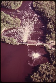
NORTHWEST PAPER COMPANY ON THE ST. LOUIS RIVER AT CLOQUET DISCHARGES SMOKE INTO THE AIR AND SULPHITE LIQUOR INTO THE RIVER ~ 1973
By the mid 20th century, the lower Saint Louis River became one of the most heavily polluted waterways in the state. Holling Clancy Holling, in his 1941 book Paddle-to-the-Sea, illustrated the polluted state of the Saint Louis River. By 1975, the river became an Environmental Protection Agency Area of Concern. The Western Lake Superior Sanitary District (WLSSD) was established in 1971 to address serious pollution problems in the lower Saint Louis River Basin. WLSSD's regional wastewater treatment plant began operating in 1978. Within two years, fish populations rebounded and anglers began returning to the river. Through the 1980s and 1990s, additional cleanups took place, but the river remains polluted. In 2013 the State of Minnesota abruptly pulled out of a project intended to research the mercury problem in the river. The cooperating agencies including Wisconsin DNR and the Fond du Lac Tribe were not in agreement with the ending of the study. The level of mercury is so high that strong limitations on consumption of the fish are in effect by the Minnesota Department of Health which for example limit consumption of walleye for a 50-pound child to 1/6 of a pound per month or no more than one pound every six months.[3][4]
Saint Louis River AOC
The Saint Louis River was listed in 1987 as an "Area of Concern" by the Great Lakes Water Quality Agreement 1987 Amendment. Nine of 14 Beneficial Use Impairments (BUIs) were identified in the Saint Louis River AOC. The AOC designation has led to the Remedial Action Plan (RAP) process outlined in the Great Lakes Water Quality Agreement (GLWQA). The most recent update is the 2013 RAP Update: A Roadmap to Delisting and can be found on the WI Department of Natural Resources (WI DNR) and Minnesota Pollution Control Agency (MPCA) webpages listed below. This document outlines the BUI removal strategies and list of actions to delist the Saint Louis River as an AOC by 2025. "Rationale for Listing: Fish samples taken from the St. Louis River and Lake
Superior exceed standards established by Minnesota and Wisconsin for the
unrestricted consumption of sport fish. Each of the two states issues
consumption advisories for various population groups, based on fish species and
size classes. Advisories are collectively issued for the presence of mercury and
polychlorinated biphenyls (PCBs). Fish tissue residues of mercury and
polychlorinated biphenyls also exceed the 0.5 mg/kg and 0.1 mg/kg standards
established in the 1978 GLWQA for the protection
of aquatic life and fish consuming birds."[5]
Recreation
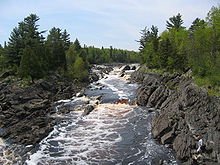
StLouisRiver Rapids ~ Photo taken from the hanging bridge in JayCooke State Park
The river is fished for walleye, northern pike, smallmouth bass, largemouth bass, bluegill, black crappie, and channel catfish populations. Other species of rough fish include Shorthead Redhorse and White Sucker. The river is frequented by those traveling the Minnesota DNR Saint Louis River Water Trail,[6] which has campsites and angling.
Attempts to introduce sturgeon are under way; sturgeon, if caught, are to be returned. While native to the river at one time, overfishing and pollution wiped them out many years ago. In 1983 the DNR, the Fond du Lac Band of Lake Superior Chippewa, and others began rebuilding spawning habitat and introducing baby sturgeon into the river. In 2016 MPR reported, "Slowly, steadily, numbers increased as the stocked fish took hold in the river. Five years ago, tribal biologists found their first fry from naturally reproducing sturgeon, a sign that a healthy fish population could grow on its own. Minnesota even began allowing catch-and-release fishing last year."[7]
The Saint Louis River Trail Association [8] is planning construction of a long-distance hiking trail along more than half the length of the river. Construction of the first 36-mile segment began in early 2012, with cooperation from the Minnesota DNR; the trail association hopes to have this section completed in 2015.
See also
- List of rivers of Minnesota
- List of rivers of Wisconsin
- Pokegama Bay
Gallery

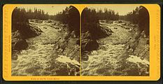
Dalles of the St. Louis, by R. N. Fearon
Falls of the St. Louis river, by Whitney & Zimmerman

Loggers at Dalles of the Saint Louis River

References
^ U.S. Geological Survey. National Hydrography Dataset high-resolution flowline data. The National Map, accessed May 1, 2012
^ Upham, Warren (1920). Minnesota Geographic Names: Their Origin and Historic Significance. St. Paul, MN: Minnesota History Society. p. 476. Retrieved 19 October 2018..mw-parser-output cite.citation{font-style:inherit}.mw-parser-output .citation q{quotes:"""""""'""'"}.mw-parser-output .citation .cs1-lock-free a{background:url("//upload.wikimedia.org/wikipedia/commons/thumb/6/65/Lock-green.svg/9px-Lock-green.svg.png")no-repeat;background-position:right .1em center}.mw-parser-output .citation .cs1-lock-limited a,.mw-parser-output .citation .cs1-lock-registration a{background:url("//upload.wikimedia.org/wikipedia/commons/thumb/d/d6/Lock-gray-alt-2.svg/9px-Lock-gray-alt-2.svg.png")no-repeat;background-position:right .1em center}.mw-parser-output .citation .cs1-lock-subscription a{background:url("//upload.wikimedia.org/wikipedia/commons/thumb/a/aa/Lock-red-alt-2.svg/9px-Lock-red-alt-2.svg.png")no-repeat;background-position:right .1em center}.mw-parser-output .cs1-subscription,.mw-parser-output .cs1-registration{color:#555}.mw-parser-output .cs1-subscription span,.mw-parser-output .cs1-registration span{border-bottom:1px dotted;cursor:help}.mw-parser-output .cs1-ws-icon a{background:url("//upload.wikimedia.org/wikipedia/commons/thumb/4/4c/Wikisource-logo.svg/12px-Wikisource-logo.svg.png")no-repeat;background-position:right .1em center}.mw-parser-output code.cs1-code{color:inherit;background:inherit;border:inherit;padding:inherit}.mw-parser-output .cs1-hidden-error{display:none;font-size:100%}.mw-parser-output .cs1-visible-error{font-size:100%}.mw-parser-output .cs1-maint{display:none;color:#33aa33;margin-left:0.3em}.mw-parser-output .cs1-subscription,.mw-parser-output .cs1-registration,.mw-parser-output .cs1-format{font-size:95%}.mw-parser-output .cs1-kern-left,.mw-parser-output .cs1-kern-wl-left{padding-left:0.2em}.mw-parser-output .cs1-kern-right,.mw-parser-output .cs1-kern-wl-right{padding-right:0.2em} (Vol. XVII of MHS Collections)
^ "Protocol for a Uniform Great Lakes Sport Fish Consumption Advisory" (PDF). Great Lakes Sport Fish Advisory Task Force. Archived from the original (PDF) on 2016-03-04.
^ "Fish Consumption Guidelines for the General Population, Rivers" (PDF).
^ http://www.earthdesign.com/SLRE/Complete_Delisting_Targets.pdf[permanent dead link]
^ Minnesota DNR: St Louis Water Trail
^ Kraker, Dan. "Northern Minn.'s St. Louis River comes back to life, but it's still not in the clear". MPR News. Retrieved September 16, 2018.
^ St. Louis River Trail Association
External links
- St. Louis River Trail Association
- St. Louis River Citizens Action Committee
- Great Lakes Areas of Concern: St. Louis River
- Minnesota Place Names
- Western Lake Superior Sanitary District
- Minnesota DNR: St. Louis River Water Trail
- WI DNR St. Louis River AOC Webpage
- MPCA St. Louis River AOC Webpage
Coordinates: 46°45′N 92°06′W / 46.75°N 92.1°W / 46.75; -92.1


