Canadian Prairies
| Canadian Prairies | |
|---|---|
| Prairies canadiennes (French) | |
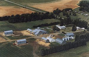 Farm on the prairies near Hartney, Manitoba | |
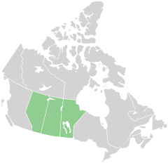 Map of the Prairie Provinces | |
| Location | Alberta, Saskatchewan, Manitoba in Canada |
| Area | 1,780,650.6 km2 (687,513.0 sq mi)[1] |
The Canadian Prairies is a region in Western Canada, which may correspond to several different definitions, natural or political. The region comprises the Canadian portion of the Great Plains, and notably, the Prairie provinces or simply the Prairies comprise the provinces of Alberta, Saskatchewan, and Manitoba, as they are partially covered by prairie (grasslands), mostly in the southern regions of each province. In a more restricted sense, the term may also refer only to the areas of those provinces covered by prairie; their portions of the physiographic region known as the Interior Plains. Prairie also covers portions of northeastern British Columbia, though that province is typically not included in the region in a political sense.[citation needed]
The prairies in Canada are a temperate grasslands and shrublands biome, within the prairie ecoregion of Canada and consists of Northern mixed grasslands in Alberta, Saskatchewan, and southern Manitoba. Northern short grasslands in southeastern Alberta and southwestern Saskatchewan.[2]Northern tall grasslands in southern Manitoba, and Aspen parkland, which covers central Alberta, central Saskatchewan, and southern Manitoba.[3] The Prairie starts from north of Edmonton, it covers the three provinces in a southward-slanting line east to the Manitoba-Minnesota border.[4] Alberta has the most land classified as Prairie, while Manitoba has the least, as the Boreal Forest begins at a lower latitude in Manitoba than in Alberta.[5]
Contents
1 Main climates
2 Physical geography
2.1 Prairies
3 Demographics
3.1 Growth
4 Economy
5 Culture and politics
6 See also
7 References
8 Further reading
8.1 Historiography
9 External links
Main climates

Köppen climate types of the Prairie Provinces

Native grasslands in southern Saskatchewan
According to the Köppen climate classification the Canadian prairies generally experience dry semi-arid climates (Köppen Bsk) in the brown soil regions, and somewhat dry Humid Continental climates (Köppen Dfb) in the outer dark brown and black soil areas. The Canadian prairies typically experience about 12 to 15 in (300 to 380 mm) of annual precipitation in the semi-arid areas while they experience 16 to 20 in (410 to 510 mm) in the continental regions. The area is also prone to thunderstorms in the spring and summer. Some of these storms, especially further south, are strong enough for tornadoes.
| City | Province | July | January | Annual precipitation | Plant hardiness zone | Average growing season (in days) |
|---|---|---|---|---|---|---|
Lethbridge[7] | AB | 26 °C/10 °C (79 °F/50 °F) | 0 °C/-12 °C (32 °F/10 °F) | 380 mm (14.9 in) | 4B | 119 |
Calgary[8] | AB | 23 °C/9 °C (73 °F/48 °F) | -1 °C/-13 °C (30 °F/9 °F) | 419 mm (16.4 in) | 4A | 117 |
Medicine Hat[9] | AB | 28 °C/12 °C (82 °F/54 °F) | -5 °C/-16 °C (23 °F/3 °F) | 323 mm (12.7 in) | 4B | 134 |
Edmonton[10] | AB | 23 °C/12 °C (73 °F/54 °F) | -6 °C/-15 °C (21 °F/5 °F) | 456 mm (17.9 in) | 4A | 135 |
Grande Prairie[11] | AB | 23 °C/10 °C (73 °F/50 °F) | -8 °C/-19 °C (18 °F/-2 °F) | 445 mm (17.5 in) | 3B | 117 |
Regina[12] | SK | 26 °C/12 °C (79 °F/54 °F) | -9 °C/-20 °C (16 °F/-4 °F) | 390 mm (15.3 in) | 3B | 119 |
Saskatoon[13] | SK | 25 °C/12 °C (77 °F/54 °F) | -10 °C/-21 °C (14 °F/-9 °F) | 354 mm (13.8 in) | 3B | 117 |
Prince Albert[14] | SK | 24 °C/12 °C (75 °F/54 °F) | -11 °C/-23 °C (12 °F/-9 °F) | 428 mm (16.8 in) | 3A | 108 |
Brandon[15] | MB | 25 °C/11 °C (77 °F/54 °F) | -11 °C/-22 °C (12 °F/-11 °F) | 474 mm (18.6 in) | 3B | 119 |
Winnipeg[16] | MB | 25 °C/12 °C (77 °F/55 °F) | -11 °C/-21 °C (12 °F/-6 °F) | 521 mm (20.5 in) | 4A | 121 |
Physical geography
Although the Prairie Provinces region is named for the prairies located within Alberta, Saskatchewan and Manitoba, the physical geography of the three provinces is quite diverse, consisting of portions of the Canadian Shield, the Western Cordillera and the Canadian Interior Plains.[17] The plains comprise both prairies and forests while, with the exception of freshwater along the Hudson Bay, the shield is predominantly forested.[18]

Gimli, Manitoba is located on Lake Winnipeg, a very large fresh water lake in the eastern prairies.
Prairies
Three main grassland types occur in the Canadian prairies: tallgrass prairie, mixed grass prairie, and fescue prairie (or using the WWF terminology, northern tall grasslands, northern mixed grasslands, and northern short grasslands).[19] Each has a unique geographic distribution and characteristic mix of plant species. All but a fraction of one percent of the tallgrass prairie has been converted to cropland. What remains occurs on the 6,000 km2 (2,300 sq mi) plain centred in the Red River Valley in Manitoba. Mixed prairie is more common and is part of the dry interior plains that extend from Canada south to the U.S. state of Texas.

The northern short grasslands (WWF terminology) shown here on a map of North America in green, is a type of true prairie (grassland) which occurs in the southern parts of the Prairie Provinces.
More than half of the remaining native grassland in the Canadian prairies is mixed. Though widespread in southern Saskatchewan and southeastern Alberta, because of extensive cattle grazing, it is estimated that only 24% of the original mixed prairie grassland remains.[citation needed] Fescue prairie occurs in the moister regions, occupying the northern extent of the prairies in central and southwestern Alberta and west-central Saskatchewan.[20]
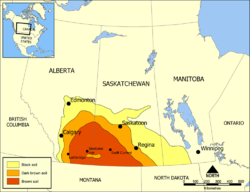
Palliser's Triangle, delineating prairie soil types in the Prairie provinces
The southwestern Canadian prairies, supporting brown and black soil types, are semi-arid and highly prone to frequent and severe droughts. The zones around the cities of Regina and immediately east of Calgary are also very dry. Most heavy precipitation quickly dissipates by the time it passes Cheadle on its way heading east. In an average year, southern Saskatchewan receives between 30–51 cm (12–20 in) of precipitation, with the majority falling between April and June. Frost from October to April (and sometimes even early May) limits the growing season for certain crops.
The eastern section of the Canadian prairies in Manitoba is well watered with several large lakes such as Lake Winnipeg and several large rivers. The area also gets reasonable amounts of precipitation. The middle sections of Alberta and Saskatchewan are also wetter than the south and have better farmland, despite having a shorter frost-free season.[citation needed] The areas around Edmonton and Saskatoon are especially notable as good farmland. Both lie in the northern area of the Palliser's Triangle, and are within aspen parkland a transitional prairie ecozone.[3][4]
Further north, the area becomes too cold for most agriculture besides wild rice operations and sheep raising, and it is dominated by boreal forest. The Peace Region in northwestern Alberta is an exception, however.[21] It lies north of the 55th Parallel and is warm and dry enough to support extensive farming. Aspen parkland covers the area; The long daylight hours in this region during the summer are an asset despite having an even shorter growing season than central Alberta. In fact, agriculture plays a major economic role in the Peace Region.
Demographics
Census metropolitan areas in the Canadian Prairies | |||||
|---|---|---|---|---|---|
| Rank | Census metropolitan area | Population (2011) | Population (2006) | Province | |
| 1 | Calgary | 1,214,839 | 1,079,310 | Alberta | |
| 2 | Edmonton | 1,159,869 | 1,034,945 | Alberta | |
| 3 | Winnipeg | 730,018 | 694,668 | Manitoba | |
| 4 | Saskatoon | 260,600 | 233,923 | Saskatchewan | |
| 5 | Regina | 210,556 | 194,971 | Saskatchewan | |
In the Canada 2011 Census, the Canadian prairie provinces had a population of 5,886,906, consisting of 3,645,257 in Alberta, 1,208,268 in Manitoba, and 1,033,381 in Saskatchewan, up 8.9% from 5,406,908 in 2006.[1] The three provinces have a combined area of 1,780,650.6 km2 (687,513.0 sq mi), consisting of 640,081.87 km2 (247,136.99 sq mi) in Alberta, 552,329.52 km2 (213,255.62 sq mi) in Manitoba, and 588,239.21 km2 (227,120.43 sq mi) in Saskatchewan.[1]

Location of communities in Alberta, Saskatchewan and Manitoba which comprise Canada's Prairie Provinces.
Growth
Some of the prairie region of Canada has seen rapid growth from a boom in oil production since the mid-20th century.[22]
According to StatsCanada, the prairie provinces had a population of 5,886,906 in 2011. In 2016, the population had grown by 14.6% to 6,748,280.[23]
Economy

A canola field in the Qu'Appelle Valley in Southern Saskatchewan.
In the mid 20th century, the economy of the prairies exploded, due to the oil boom, and introduced a growth of jobs. The primary industries are agriculture and services.[24]Agriculture consisting of livestock(cattle and sheep), cultivating crops (oats, canola, wheat, barley), and production of oil.[25] Due to the production of oil, the service industry expanded in order to provide for the employees of the oil companies extracting the oil. In the 1950s-1970s, the explosion of oil production increased the worth of Alberta and allowing it to become the “nations richest province” and Canada one of the top petroleum exporters in the world.[26] Edmonton and Calgary drew in a larger population with the increase in jobs in the energy field, which causes the jobs supporting this field to grow as well. It was through the steady economic growth that followed this explosion that the prairies region began to switch from an agriculture-based job sector to one with services included.[27] In 2014, the global market for oil fell and led to a recession, impacting the economy dramatically. Alberta still has an oil dominant economy even as the traditional oil wells dry up, there are oil sands further north (ie. Fort McMurray) that continue to provide jobs to extract, drill and refine the oil.[28] Saskatchewan, in particular, in the early 20th century grew economically due to the Canadian agricultural boom and produce large crops of wheat.[29] It is said to have a “one-crop economy” due to such dependency on this crop alone, but after 1945 the economy took another turn with technological advancements that allowed for the discovery of uranium, oil, and potash.[30]
Culture and politics

The Alberta badlands.
The Prairies are distinguished from the rest of Canada by cultural and political traits. The oldest influence on Prairie culture are the First Nations, who have lived in the area for millennia. The first Europeans to see the Prairies were fur traders and explorers from eastern Canada (mainly present-day Quebec) and Great Britain via Hudson Bay. They gave rise to the Métis, working class "children of the fur trade." Not until the Canadian Pacific Railway was built did widespread agricultural settlement occur. During their settlement, the prairies were settled in distinct ethnic block settlements giving certain areas distinctively Ukrainian, German, French, or Scandinavian Canadian cultures.
Some areas also developed cultures around their main economic activity. For example, southern Alberta is renowned for its cowboy culture, which developed when real open range ranching was practised in the 1880s. Canada's first rodeo, the Raymond Stampede, was established in 1902. These influences are also evident in the music of Canada's Prairie Provinces. This can be attributed partially to the massive influx of American settlers who began to migrate to Alberta (and to a lesser extent, Saskatchewan) in the late 1880s because of the lack of available land in the United States.
The Prairie Provinces have given rise to the "prairie protest" movements, such as the Winnipeg General Strike of 1919, the first general strike in Canadian history. These political movements (both of the left and right) tend to feed off of well established feelings of Western alienation, and each one represents a distinct challenge to the perceived Central Canadian elite.
The Prairies continue to have a wide range of political representation. While the Conservative Party of Canada has widespread support throughout the region, the New Democratic Party holds seats at the provincial level in all three provinces, forming the government in one, as well as holding seats at the federal level in all three provinces. The Liberal Party of Canada presently holds federal seats in urban areas of Alberta, Saskatchewan and Manitoba, while the Alberta Liberal Party holds a provincial seat in Alberta and the Manitoba Liberal Party holds four seats in Manitoba.
See also
- List of regions of Canada
- Dominion Land Survey
- Natural Resources Acts
- Terrestrial ecozone
- High Plains (United States)
- Llano Estacado
- Shortgrass prairie
Corner Gas – TV show featuring the sparseness of the plains as a major theme
References
^ abc "Population and dwelling counts, for Canada, provinces and territories, 2011 and 2006 censuses". Statistics Canada. 2012-01-24. Archived from the original on 2014-03-07. Retrieved 2012-03-17..mw-parser-output cite.citation{font-style:inherit}.mw-parser-output .citation q{quotes:"""""""'""'"}.mw-parser-output .citation .cs1-lock-free a{background:url("//upload.wikimedia.org/wikipedia/commons/thumb/6/65/Lock-green.svg/9px-Lock-green.svg.png")no-repeat;background-position:right .1em center}.mw-parser-output .citation .cs1-lock-limited a,.mw-parser-output .citation .cs1-lock-registration a{background:url("//upload.wikimedia.org/wikipedia/commons/thumb/d/d6/Lock-gray-alt-2.svg/9px-Lock-gray-alt-2.svg.png")no-repeat;background-position:right .1em center}.mw-parser-output .citation .cs1-lock-subscription a{background:url("//upload.wikimedia.org/wikipedia/commons/thumb/a/aa/Lock-red-alt-2.svg/9px-Lock-red-alt-2.svg.png")no-repeat;background-position:right .1em center}.mw-parser-output .cs1-subscription,.mw-parser-output .cs1-registration{color:#555}.mw-parser-output .cs1-subscription span,.mw-parser-output .cs1-registration span{border-bottom:1px dotted;cursor:help}.mw-parser-output .cs1-ws-icon a{background:url("//upload.wikimedia.org/wikipedia/commons/thumb/4/4c/Wikisource-logo.svg/12px-Wikisource-logo.svg.png")no-repeat;background-position:right .1em center}.mw-parser-output code.cs1-code{color:inherit;background:inherit;border:inherit;padding:inherit}.mw-parser-output .cs1-hidden-error{display:none;font-size:100%}.mw-parser-output .cs1-visible-error{font-size:100%}.mw-parser-output .cs1-maint{display:none;color:#33aa33;margin-left:0.3em}.mw-parser-output .cs1-subscription,.mw-parser-output .cs1-registration,.mw-parser-output .cs1-format{font-size:95%}.mw-parser-output .cs1-kern-left,.mw-parser-output .cs1-kern-wl-left{padding-left:0.2em}.mw-parser-output .cs1-kern-right,.mw-parser-output .cs1-kern-wl-right{padding-right:0.2em}
^ Quiring, S. M; Papakryiakou, T. N. (2003). "An evaluation of agricultural drought indices for the Canadian prairies". Agricultural and forest meteorology. 118 (1–2): 49–62.
^ ab "Prairies Ecozone". Ecological Framework of Canada. Government of Canada. Archived from the original on 2 June 2016. Retrieved 23 May 2016.
^ ab "Wide open spaces, but for how long?". The Royal Canadian Geographical Society. The Royal Canadian Geographical Society. 2014-10-16. Archived from the original on 3 April 2016. Retrieved 23 May 2016.
^ Quiring, S. M; Papakryiakou, T. N. (2003). "An evaluation of agricultural drought indices for the Canadian prairies". Agricultural and forest meteorology. 118 (1–2): 49–62.
^ "Canada's Plant Hardiness". Canada's Plant Hardiness. Natural Resources Canada. Archived from the original on 5 March 2016. Retrieved 5 January 2016.
^ "Lethbridge A, Alberta". Canadian Climate Normals 1981–2010. Environment Canada. 2013-09-25. Archived from the original on 12 May 2014. Retrieved 12 May 2014.
^ "Canadian Climate Normals 1981-2010 Station Data Calgary International Airport". Environment Canada. 2013-09-25. Archived from the original on 4 March 2016. Retrieved 15 July 2015.
^ "Medicine Hat A, Alberta". Canadian Climate Normals 1981–2010 Medicine Hat. Environment Canada. 2013-09-25. Archived from the original on 6 October 2014. Retrieved 14 May 2014.
^ "Edmonton City Centre Airport". Canadian Climate Normals 1981−2010. Environment Canada. August 19, 2013. Archived from the original on March 4, 2016. Retrieved September 10, 2013.
^ "Grande Prairie A". Canadian Climate Normals 1981−2010. Environment Canada. 2013-09-25. Archived from the original on May 14, 2014. Retrieved May 14, 2014.
^ "Regina International Airport". Canadian Climate Normals 1981–2010. Environment Canada. 2013-09-25. Archived from the original on 12 May 2014. Retrieved 12 May 2014.
^ "Saskatoon Diefenbaker International Airport". Canadian Climate Normals 1981–2010. Environment Canada. 2013-09-25. Archived from the original on May 13, 2014. Retrieved May 12, 2014.
^ "Prince Albert A". Canadian Climate Normals 1981–2010. Environment Canada. 2013-09-25. Archived from the original on May 14, 2014. Retrieved May 14, 2014.
^ "Brandon CDA, Manitoba". Canadian Climate Normals 1981–2010. Environment Canada. 2013-09-25. Archived from the original on 8 May 2014. Retrieved 7 May 2014.
^ "Winnipeg Richardson International Airport". Canadian Climate Normals 1981–2010. Environment Canada. 2013-09-25. Archived from the original on February 11, 2015. Retrieved May 7, 2014.
^ Baldwin, D. J., Desloges, J. R., & Band, L. E. (2000). "Physical geography of Ontario" (Ecology of a managed terrestrial landscape: patterns and processes of forest landscapes in Ontario): 12–29.CS1 maint: Multiple names: authors list (link)
^ Baldwin, D. J., Desloges, J. R., & Band, L. E. (2000). "Physical geography of Ontario" (Ecology of a managed terrestrial landscape: patterns and processes of forest landscapes in Ontario): 12–29.CS1 maint: Multiple names: authors list (link)
^ Williams, G. D. V., Joynt, M. I., & McCormick, P. A. (1975). "Regression analyses of Canadian prairie crop-district cereal yields, 1961–1972, in relation to weather, soil and trend". Canadian Journal of Soil Science (55 (1)).CS1 maint: Multiple names: authors list (link)
^ "Prairie Grasslands and Parkland". Archived from the original on 2010-05-27.
^ Price, David T.; Alfaro, R.I.; Brown, K.J.; Flannigan, M.D.; Fleming, R.A.; Hogg, E.H.; Girardin, M.P.; Lakusta, T.; Johnston, M.; McKenney, D.W.; Pedlar, J.H.; Stratton, T.; Sturrock, R.N.; Thompson, I.D.; Trofymow, J.A.; Venier, L.A. (1 December 2013). "Anticipating the consequences of climate change for Canada's boreal forest ecosystems". Environmental Reviews. 21 (4): 322–365. doi:10.1139/er-2013-0042. ISSN 1181-8700.
^ "Atlantic unemployment tonic: oil sands". Archived from the original on 2008-10-20.
^ "Archived copy". Archived from the original on 2017-05-04. Retrieved 2017-05-04.CS1 maint: Archived copy as title (link)
^ "The Prairies". The Canada Guide.
^ "Facts About The Canadian Prairie Provinces". World Atlas.
^ "Facts About The Canadian Prairie Provinces". World Atlas.
^ Friesen, G (1987). The Canadian prairies: A history. University of Toronto Press.
^ "Facts About The Canadian Prairie Provinces". World Atlas.
^ "The Prairies". The Canada Guide.
^ "The Prairies". The Canada Guide.
Further reading
Alberta Encyclopedia Online (2005)- Archer, John H. Saskatchewan: A History (1980)
- Barnhart, Gordon L., ed. Saskatchewan Premiers of the Twentieth Century. (2004). 418 pp.
- Bennett, John W. and Seena B. Kohl. Settling the Canadian-American West, 1890-1915: Pioneer Adaptation and Community Building. An Anthropological History. (1995). 311 pp. online edition
- Danysk, Cecilia. Hired Hands: Labour and the Development of Prairie Agriculture, 1880–1930. (1995). 231 pp.
- Emery, George. The Methodist Church on the Prairies, 1896–1914. McGill-Queen's U. Press, 2001. 259 pp.
The Encyclopedia of Saskatchewan: A Living Legacy. U. of Regina Canadian Plains Research Center, 2005. online 1071pp in print edition- Fairbanks, C. and S.B. Sundberg. Farm Women on the Prairie Frontier. (1983)
Friesen, Gerald (1987), The Canadian prairies: a history, University of Toronto Press, ISBN 978-0-8020-6648-0
- Hodgson, Heather, ed. Saskatchewan Writers: Lives Past and Present. Regina: Canadian Plains Research Center, 2004. 247 pp.
- Jones, David C. Empire of Dust: Settling and Abandoning the Prairie Dry Belt. (1987) 316 pp.
- Keahey, Deborah. Making It Home: Place in Canadian Prairie Literature. (1998). 178 pp.
Kononenko, Natalie "Vernacular religion on the prairies: negotiating a place for the unquiet dead," Canadian Slavonic Papers 60, no. 1-2 (2018)- Langford, N. "Childbirth on the Canadian Prairies 1880-1930." Journal of Historical Sociology, 1995. Vol. 8, No. 3, pp. 278–302.
- Langford, Nanci Louise. "First Generation and Lasting Impressions: The Gendered Identities of Prairie Homestead Women." PhD dissertation U. of Alberta 1994. 229 pp. DAI 1995 56(4): 1544-A. DANN95214 Fulltext: ProQuest Dissertations & Theses
- Laycock, David. Populism and Democratic Thought in the Canadian Prairies, 1910 to 1945. (1990). 369 pp.
- Melnyk, George. The Literary History of Alberta, Vol. 1: From Writing-on-Stone to World War Two. U. of Alberta Press, 1998. 240 pp.
- Morton, Arthur S. and Chester Martin, History of prairie settlement (1938) 511pp
- Morton, W. L. Manitoba, a History University of Toronto Press, 1957 online edition
- Norrie, K. H. "The Rate of Settlement of the Canadian Prairies, 1870–1911", Journal of Economic History, Vol. 35, No. 2 (Jun., 1975), pp. 410–427 in JSTOR; statistical models
- Palmer, Howard. The Settlement of the West (1977) online edition
- Pitsula, James M. "Disparate Duo" Beaver 2005 85(4): 14–24, a comparison of Saskatchewan and Alberta, Fulltext in EBSCO
- Rollings-Magnusson, Sandra. "Canada's Most Wanted: Pioneer Women on the Western Prairies". Canadian Review of Sociology and Anthropology 2000 37(2): 223–238.
ISSN 0008-4948 Fulltext: Ebsco
- Swyripa, Frances. Storied Landscapes: Ethno-Religious Identity and the Canadian Prairies (University of Manitoba Press, 2010) 296 pp.
ISBN 978-0-88755-720-0. - Thompson, John Herd. Forging the Prairie West (1998).
- Wardhaugh, Robert A. Mackenzie King and the Prairie West (2000). 328 pp.
- Waiser, Bill, and John Perret. Saskatchewan: A New History (2005).
Historiography
- Francis, R. Douglas. "In search of a prairie myth: A survey of the intellectual and cultural historiography of prairie Canada." Journal of Canadian Studies/Revue d'Études Canadiennes 24#3 (1989): 44+ online
Ingles, Ernie B (2009), Peel's Bibliography of the Canadian Prairies to 1953, University of Toronto Press, ISBN 978-0-8020-4825-7
- Wardhaugh, Robert A., ed. Toward Defining the Prairies: Region, Culture, and History. (2001). 234 pp.
Wardhaugh, Robert; Calder, Alison (2005), History, literature, and the writing of the Canadian Prairies, University of Manitoba Press, ISBN 978-0-88755-682-1 310 pp.
External links
 Media related to Canadian Prairies at Wikimedia Commons
.mw-parser-output .navbox-canada .navbox-title,.mw-parser-output .navbox-canada th,.mw-parser-output .navbox-canada .navbox-group,.mw-parser-output .navbox-canada .navbox-abovebelow,.mw-parser-output .navbox-canada .navbox-subgroup,.mw-parser-output .navbox-canada .navbox-odd,.mw-parser-output .navbox-canada .navbox-even{background-color:white}.mw-parser-output .navbox-canada .navbox-list .collapsible .navbox-title{box-shadow:inset 1px 1px 0 #C00,inset -1px -1px 0 #C00}.mw-parser-output .navbox-canada-a{box-shadow:inset 1px 1px 0 #C00,inset -1px -1px 0 #C00}.mw-parser-output .navbox-canada-t{box-shadow:inset 0 1px 0 0 #C00}.mw-parser-output .navbox-canada-b{box-shadow:inset 0 -1px 0 0 #C00}.mw-parser-output .navbox-canada-tb{box-shadow:inset 0 1px 0 0 #C00,inset 0 -1px 0 0 #C00} | |||||||
|---|---|---|---|---|---|---|---|
| Physiographic sub-regions |
| ||||||
| Physical features |
| ||||||
| Ecozones |
| ||||||
| Parks and protected areas |
| ||||||
| Historic regions | Red River Colony/Selkirk Concession | ||||||
| Aboriginal peoples |
| ||||||
| |||||||
| History |
| ||||
|---|---|---|---|---|---|
| Provinces and territories |
| ||||
| Government |
| ||||
| Politics |
| ||||
| Geography |
| ||||
| Economy |
| ||||
| Society |
| ||||
| Demographics |
| ||||
| Culture |
| ||||
| Symbols |
| ||||
| Article overviews |
| ||||
| Research |
| ||||
| |||||
Earth's primary regions | |||||||||||||||||
|---|---|---|---|---|---|---|---|---|---|---|---|---|---|---|---|---|---|
| |||||||||||||||||
Authority control |
|
|---|


